
According to the Department of Agriculture and Environment, in recent times, heavy rains in the province have led to rapidly saturated and waterlogged soil, reducing soil cohesion, leading to instability of river banks and beaches, causing a high risk of landslides and erosion at river banks. Through inspection, it was discovered that the area K8+100 - K8+500 of the left dike of Cau River continued to experience landslides on the left dike of Cau River in Bao Tan village, Hop Thinh commune with a total landslide area length of about 400m (the landslides are connected continuously, eating into the river bank from 4-5.5m).
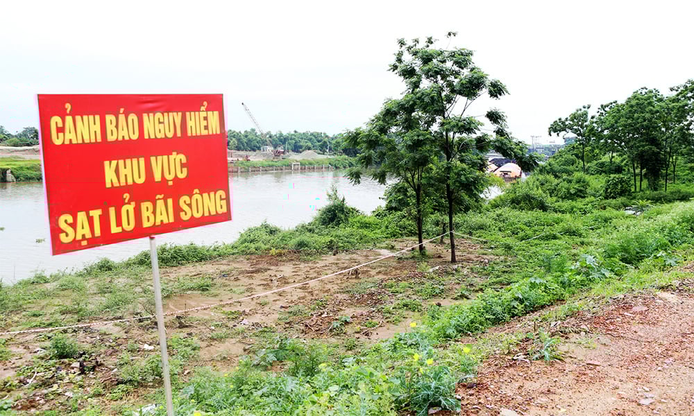 |
Illustration photo. |
There are 2 particularly dangerous landslides, No. 1 (location K8+370-K8+420) goes deep into the beach about 5m, the closest landslide peak is 22m from the edge of the concrete dike on the river side, 50m long. No. 2 (location K8+460-K8+485) is 26m from the edge of the concrete dike on the river side, 25m long. In addition, some landslides in the area K8+100-K8+250 continue to develop, going deep into the beach, the landslide peak is close to the households living there.
Faced with the above situation, the Chairman of the Provincial People's Committee requested the Chairman of the People's Committee of Hop Thinh commune to urgently organize tree cutting, clear the areas where the incident occurred, arrange access and exit to inspect the area; set up markers, mark landmarks for monitoring, and keep a book to closely monitor the landslide developments. String up ropes and put up warning signs in areas with landslides on river banks and beaches, and restrict trucks from passing through the area.
Continue to promote propaganda and mobilize some households living near dangerous landslide areas to evacuate assets and people, ensuring safety of life and property.
Organize a review and make a list of households living in the riverside area of the dike section from K8+100-K8+500 on the left bank of the Cau; check the issuance of Land Use Right Certificates, the construction of housing projects, especially ancillary projects close to the riverbank and riverbank.
Immediately develop an emergency evacuation plan for households in landslide areas when landslides become dangerous and unsafe, and arrange to ensure social security and stabilize the lives of households.
Supplement the key plan to handle riverbank landslides in the incident area and submit it to the Provincial People's Committee for approval before July 10, 2025; at the same time, prepare materials, human resources, and means to proactively handle the situation according to the "4 on-site" motto.
Organize forces to regularly monitor incident developments and regularly report to the Standing Office of the Provincial Steering Committee for Natural Disaster Prevention and Search and Rescue (Department of Irrigation, Department of Agriculture and Environment).
Assign the Irrigation Sub-Department to continue researching and supplementing the plan to handle the incident of landslides on river banks and beaches in the K8+250 - K8+500 area of the left dike of Cau Bridge into the overall plan for the entire K8+100 - K8+500 area in accordance with regulations, ensuring the safety of the dike during the 2025 storm season; the results will be reported to the Department of Agriculture and Environment in July 2025.
The Department of Agriculture and Environment directs and urges the Irrigation Sub-Department to develop a plan to handle incidents; regularly monitor developments, promptly report to the Ministry of Agriculture and Environment, the Department of Dyke Management and Natural Disaster Prevention and Control; at the same time propose and advise the Chairman of the Provincial People's Committee to organize and implement incident handling in accordance with legal regulations.
Source: https://baobacninhtv.vn/khan-truong-xu-ly-su-co-sat-lo-bo-bai-song-khu-vuc-de-ta-cau-xa-hop-thinh-postid421576.bbg


![[Photo] Gia Lai provincial leaders offer flowers at Uncle Ho's Monument with the ethnic groups of the Central Highlands](https://vphoto.vietnam.vn/thumb/1200x675/vietnam/resource/IMAGE/2025/7/9/196438801da24b3cb6158d0501984818)


Comment (0)