
According to the National Center for Hydro-Meteorological Forecasting, on the night of July 4, a tropical depression in the northeastern sea of the North East Sea strengthened into a storm, the second storm in 2025.
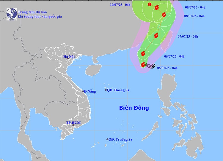
At 4:00 am on July 5, the center of the storm was located at about 20.1 degrees North latitude, 117.4 degrees East longitude, in the northeastern part of the East Sea. The strongest wind near the center of the storm was level 8 (62-74 km/h), gusting to level 10. The storm slowly moved in a West-Northwest direction at a speed of about 5-10 km/h.
It is forecasted that in the next 24 hours, storm No. 2 is likely to strengthen. At 4:00 am on July 6, the storm center was at about 21.8 degrees North latitude, 117.4 degrees East longitude, continuing to be located in the northeastern waters of the East Sea. The intensity disaster increased to level 9 - 10, gusting to level 12. The dangerous area at sea at this time is from latitude 18.5 to 23.5 degrees North latitude, longitude 115.5 to 120.0 degrees East longitude - this sea area is determined to have a level 3 natural risk.
From July 6 to 7, the storm continued to move in a north-northeast direction at a speed of about 15 km/hour. At 4:00 am on July 7, the center of the storm was located in the sea of Fujian province (China), at about 24.6 degrees North latitude, 119.4 degrees East longitude. The strongest wind was level 10-11, gusting to level 13. The sea area north of latitude 19.5 degrees North latitude and east of longitude 115.5 degrees East longitude remains in the danger zone, continuing to maintain level 3 natural disaster risk.
It is forecasted that by 4:00 am on July 8, the storm will move deep into the mainland along the coast of Zhejiang province (China), with wind speed slightly decreasing to level 10, gusting to level 12.
The northeastern sea area of the North East Sea will have strong winds of level 7, near the storm center of level 8-10, gusting to level 12. Waves 3-5 m high, very sea roughs. The area between the East Sea and the sea area from Lam Dong to Ca Mau will have southwest winds of level 5, sometimes level 6, gusting to level 7-8, waves 2-4 m high; rough seas.
In particular, during the day and night of July 6, the northeastern sea area of the North East Sea continues to have strong winds of level 7-8, near the storm center level 9-11, gusting to level 13. Waves are 4-6 m high, the sea is very rough. The sea area between the East Sea and the sea area from Khanh Hoa to Ca Mau continues to be affected by strong southwest winds of level 5-6, gusting to level 7-8, waves 2-4 m high.
Given the complex developments of the storm, authorities recommend that vessels operating in the northeastern area of the East Sea, especially dangerous areas, proactively move out of the storm's affected area or find safe shelter.
Coastal localities from Quang Ninh to Khanh Hoa are required to closely monitor the storm's developments to have appropriate response plans.
Weather forecast for regions across the country on July 5:
The Northwestern region is cloudy with scattered showers and thunderstorms. Light winds. Thunderstorms may cause tornadoes, lightning and strong gusts of wind. The lowest temperature is 24 - 27 degrees Celsius, some places below 23 degrees Celsius. The highest temperature is 31 - 34 degrees Celsius, some places above 34 degrees Celsius.
The northeastern provinces are cloudy with scattered showers and thunderstorms. Light winds. Thunderstorms are likely to produce tornadoes, lightning and strong gusts of wind. Lowest temperature 24 - 27 degrees Celsius. Highest temperature 31 - 34 degrees Celsius, some places above 34 degrees Celsius.
Provinces from Thanh Hoa to Hue will be cloudy with scattered showers and thunderstorms; In the late afternoon and evening, there will be scattered showers and thunderstorms, with some heavy rain in some places. Light wind. During thunderstorms, there is a possibility of tornadoes, lightning and strong gusts of wind. Lowest temperature 25 - 28 degrees Celsius. Highest temperature 31 - 34 degrees Celsius.
The South Central Coast region is cloudy with scattered showers and thunderstorms; in the North, in the late afternoon and evening, there will be scattered showers and thunderstorms, with some places having heavy rain. Southwestern winds level 2-3. There is a possibility of tornadoes, lightning and strong gusts of wind during thunderstorms. The lowest temperature is 25-28 degrees Celsius. The highest temperature is 31-34 degrees Celsius, with some places above 34 degrees Celsius.
The Central Highlands is cloudy with scattered showers and thunderstorms; In the afternoon and evening there will be scattered showers and thunderstorms, with some heavy rain in some places. Southwestern winds level 2-3. There is a possibility of tornadoes, lightning and strong gusts of wind during thunderstorms. Lowest temperature 20-23 degrees Celsius. Highest temperature 26-29 degrees Celsius.
The South is cloudy with scattered showers and thunderstorms in some places; in the afternoon and evening there will be scattered showers and thunderstorms, with some places having heavy rain. Southwestern winds level 2 - 3. There is a possibility of tornadoes, lightning and strong gusts of wind during thunderstorms. Lowest temperature 24 - 27 degrees Celsius. Highest temperature 30 - 33 degrees Celsius, some places above 33 degrees Celsius.
Source: https://baohaiphongplus.vn/bao-manh-xuat-hien-tren-bien-dong-415646.html


Comment (0)