
A strong tropical depression of level 6, gusting to level 8, formed in the East Sea this morning and is forecast to continue to strengthen in the next 24 hours.
The National Center for Hydro-Meteorological Forecasting said that on the morning of July 4, the low pressure area in the northeastern sea of the North East Sea strengthened into a tropical depression.
At 7:00 a.m., the center of the tropical depression was at about 20.0 degrees North latitude; 119.0 degrees East longitude. The strongest wind near the center of the tropical depression was level 6 (39-49 km/h), gusting to level 8, moving in the West Northwest direction at a speed of about 10 km/h.
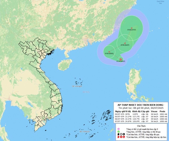
It is forecasted that in the next 24 hours, the tropical depression will be about 780km northeast of Hoang Sa special zone, moving in a West-Northwest direction, traveling about 10-15km per hour and is likely to strengthen. The strongest wind near the storm center is level 6-7, gusting to level 8.
It is forecasted that by 7am on July 6, the tropical depression in the sea southwest of Taiwan (China) will change direction to East Northeast at a speed of 15-20km/h and may strengthen.
From the next 48 to 72 hours, the tropical depression will move in the North Northeast direction at a speed of 15-20km/h.
Impact of tropical depression, the northeastern sea area of the North East Sea has thunderstorms and strong winds of level 6, sometimes level 7, gusting to level 9, rough seas, waves 2-4m high.
On the mainland of our country, rain continued to pour down in the North, Central Highlands and South last night and this morning, with some places experiencing heavy rain. The rainfall from 7pm on July 3 to 7am on July 4 was over 40mm in some places such as: Khang Ninh (Thai Nguyen) 70.4mm; Dao San ( Lai Chau ) 48.2mm; An Lac (Phu Tho) 46.8mm; Hong Thai (Tuyen Quang) 44.2mm...
On the afternoon and night of July 4, from Thanh Hoa to Quang Ngai , the Central Highlands and the South, there will be scattered showers and thunderstorms, locally heavy rain with rainfall of 10-30mm, locally over 50mm.
During thunderstorms, there is a risk of tornadoes, lightning, hail and strong gusts of wind. Localized heavy rain can cause flash floods on small rivers and streams, landslides on steep slopes and flooding in low-lying areas.
Source: https://baolangson.vn/bien-dong-don-ap-thap-nhiet-doi-5052150.html


Comment (0)