

The strongest wind near the storm center is level 10 (89-102km/h), gusting to level 12; moving slowly in the North Northeast direction at a speed of about 5km/h.
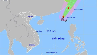
Commenting on the development of storm No. 2, Director of the National Center for Hydro-Meteorological Forecasting Mai Van Khiem said that by 7 pm on July 6, the storm was in the northeastern sea area of the East Sea with strong winds of level 10-11, gusting to level 13 and likely to strengthen.
The storm is moving in a North-Northeast direction at a speed of 10 km/h. The affected area is the northeastern sea area of the North East Sea. Disaster risk level 3.
At 7:00 pm on July 7, the storm was in the sea of Fujian province (China) with strong winds of level 10, gusts of level 12. The storm moved in a North-Northeast direction at a speed of 15-20 km/h. The affected area was the northeastern sea area of the North East Sea. Disaster risk level 3.
At 7:00 pm on July 8, the storm was on land in Zhejiang province (China) with strong winds of level 8, gusting to level 10. The storm moved in a North-Northwest direction at a speed of 10 km/h.
From the next 72 to 96 hours, the storm moved in the West Northwest direction at a speed of about 10-15km/h and gradually weakened into a low pressure area.
Due to the impact of the storm, the northeastern sea area of the North East Sea has stormy rain and strong winds of level 7-9, the area near the storm's center has winds of level 10-11, gusts of level 13, rough seas, waves 4-6m high.
Ships operating in the above mentioned dangerous areas are likely to be affected by storms, whirlwinds, strong winds and large waves.
Source: https://www.sggp.org.vn/bao-so-2-tang-cap-va-di-chuyen-theo-huong-bac-dong-bac-post802615.html


![[Photo] Prime Minister Pham Minh Chinh receives leaders of several leading Brazilian corporations](https://vphoto.vietnam.vn/thumb/1200x675/vietnam/resource/IMAGE/2025/7/6/3622160b379746e6bca82f804ea35e47)


![[OCOP REVIEW] Bay Quyen sticky rice cake: A hometown specialty that has reached new heights thanks to its brand reputation](https://vphoto.vietnam.vn/thumb/402x226/vietnam/resource/IMAGE/2025/7/3/1a7e35c028bf46199ee1ec6b3ba0069e)


Comment (0)