
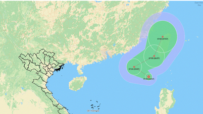
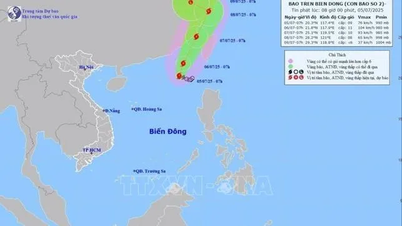
Forecast, by 13:00 tomorrow (July 6), the storm center is in the northeastern sea of the East Sea, moving in the North-Northeast direction, speed 5-10km/hour and is likely to strengthen (level 10-11, gust level 13).

At 1:00 pm on July 7, the storm center was over the sea of Fujian province (China), moving in a North-Northeast direction, at a speed of 15-20 km/h, with a storm intensity of level 10, gusting to level 12.
At 1:00 pm on July 8, the storm center was on the coastal area of Zhejiang province (China), the strongest wind near the storm center was at level 8, gusting to level 12.
From the next 72 to 96 hours, the storm will move in the West Northwest direction at a speed of about 10km/hour and gradually weaken into a low pressure area.
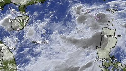
Due to the influence of the storm, the northeastern sea area of the North East Sea has strong winds of level 7-8, the area near the storm's center has winds of level 9-11, gusting to level 13. The sea is rough, with waves 4.0-6.0m high.
Vessels operating in danger zones are at high risk of being affected by storms, tornadoes, strong winds and large waves.
Source: https://www.sggp.org.vn/bao-so-2-danas-co-kha-nang-giat-cap-13-post802588.html


![[OCOP REVIEW] Bay Quyen sticky rice cake: A hometown specialty that has reached new heights thanks to its brand reputation](https://vphoto.vietnam.vn/thumb/402x226/vietnam/resource/IMAGE/2025/7/3/1a7e35c028bf46199ee1ec6b3ba0069e)


Comment (0)