


The trend of "looking back at the past" through Google Maps is causing a "storm" on the internet.
For weeks now, TikTok, Facebook Reels, and Instagram have been flooded with "before - after" posts, where Google Maps users "rewind" images of houses, shops, or streets that were once filled with memories but have now completely changed, or even disappeared.
When Google Maps becomes a "memory warehouse"
The secret behind this trend is Google Maps’ Street View feature, which captures 360° images of routes and locations, stored over many surveys by specialized vehicles. Since 2014, Google has added the ability to “time travel,” allowing users to select a year in the past to see how a location has changed.
Thanks to that, with just a few simple steps, anyone can rewind time and compare the scenery of the past and present.
This trend quickly spread strongly because it touched many people's emotions. Users were moved when seeing a familiar coffee shop, a small street, or an old apartment building from their childhood now changed. Along with that, the speed of urbanization made the change of the landscape obvious, making many people surprised and excited when looking back at the before and after images.
Furthermore, Google Maps tools are easy to use, anyone can manipulate and share, creating a feeling of deep connection with others through shared memories.

Many people can find images that seem to be just memories through Google Maps.
Not only comparing the past and present, users also tell stories about memories of old locations, analyzing positive or negative changes: a once bustling neighborhood is replaced by a skyscraper, or a park is demolished to build a shopping mall...
Some people also look deeply into architectural styles and landscapes through different periods, raising awareness of preserving urban heritage. Many young people turn "rewinding Google Maps" into a form of treasure hunting, searching for historical relics before they disappear from reality.
Currently, the online community is especially sharing images of old apartment buildings in Hanoi that have been demolished and replaced by new apartment buildings; or traditional markets such as Ba Chieu Market and Cau Muoi Market that have been narrowed and cleared; as well as the expanded roads in Saigon that have completely changed the landscape.
Times Google Maps "shook" the world
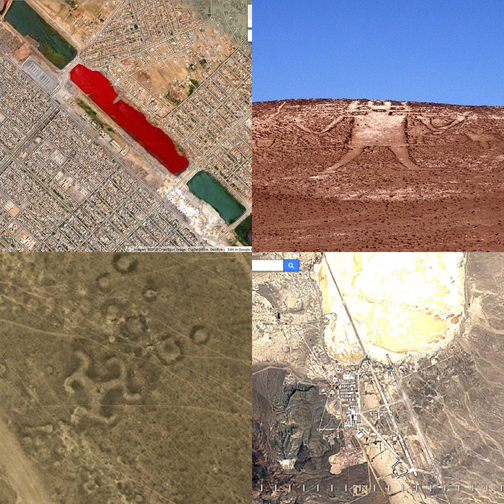
According to Tuoi Tre Online, Google Maps and Google Earth not only help users find their way but also accidentally reveal countless strange images around the world, which have caused a stir in the online community. A typical example is the discovery of a "blood lake" in Sadr City, Iraq, in 2007 with a blood-red color that made many people speculate about a massacre or pollution, although it was later explained by bacteria or dye chemicals.
In Myanmar, netizens once saw the wreckage of an old transport plane lying in the middle of the jungle through Google Earth, which was confirmed to have crashed decades ago. The Atacama Desert, Chile is also famous for its giant humanoid figure dating back more than 1,000 years, measuring 119m long, "Atacama Giant" spread around the world thanks to satellite images.
There was even talk in 2019 of a "Titanic wreck" at the bottom of the Atlantic Ocean when satellite images captured a ship of similar size, but experts confirmed it was just an old cargo ship.
A series of other mysterious areas blurred out by Google Maps, from Area 51 (USA), nuclear facilities in Israel, to Russian missile bases, have further fueled conspiracy theories.
Another case that has left the community horrified is a Street View photo in the Netherlands, where a person appears to be lying in a pool of blood on a dock, but is actually just a dog playing and leaving a red stain on the wooden floor.
Additionally, in 2014, Google Earth helped archaeologists discover more than 260 giant stone drawings in Kazakhstan, dubbed the Kazakh version of the "Nazca Lines" dating back thousands of years.
In Australia, a giant black triangle appeared on satellite images, also sparking rumors of a UFO base, but was eventually determined to be just a special geometric tree farm...
These strange discoveries have turned Google Maps into a tool that not only guides but also arouses the curiosity and imagination of millions of people around the world.
Mysterious photos that "shook" the world from Google Maps
Multidimensional social impact
On the positive side, this trend helps the community see more clearly the speed of urbanization, as well as opening up opportunities to preserve collective memories. Young generations also learn to appreciate the cultural and historical space associated with each road and street corner.
However, there are also opinions that looking back at old images can evoke sadness, when people remember the time when they had to leave due to clearance, relocation or loss of familiar places.
Some other debates arose around the demolition of old buildings, the conflict of interests between heritage preservation and modern development.
In addition, although Google has regulations to blur license plates and faces, many people still have concerns about privacy, because images of homes or personal lives in the past can also be dug up again unintentionally.
What are Street View and Travel Time features?
Street View is a feature of Google Maps and Google Earth that allows users to view 360-degree images at street level, as if they were standing directly at that location. These images are collected by Google using specialized vehicles equipped with omnidirectional cameras, or contributed by the community, helping to recreate realistic scenes of roads, buildings and locations around the world.
Thanks to that, users can look up directions, survey landscapes, explore tourist attractions, cultural relics or even "wander" in strange alleys, opening up a vivid space experience right on the screen.
The Time Travel feature is an extension of Street View, which appeared in 2014, allowing users to return to old images that Google has stored at the same location through different shooting sessions.
By clicking on the clock icon on the Street View interface, users can select specific years (e.g. 2012, 2015, 2019…) to compare the changes in the landscape over time. This is a great tool to observe the urbanization process, research local history, compare before and after of a construction, or simply preserve memories through digital photos.
Source: https://tuoitre.vn/trao-luu-nhin-lai-qua-khu-va-nhung-lan-google-maps-gay-sot-mang-2025070309551342.htm
![[Photo] Prime Minister Pham Minh Chinh receives CEO of Samsung Electronics](https://vphoto.vietnam.vn/thumb/1200x675/vietnam/resource/IMAGE/2025/8/26/373f5db99f704e6eb1321c787485c3c2)
![[Photo] Multi-colored cultural space at the Exhibition "80 years of the journey of Independence - Freedom - Happiness"](https://vphoto.vietnam.vn/thumb/1200x675/vietnam/resource/IMAGE/2025/8/26/fe69de34803e4ac1bf88ce49813d95d8)


![[Photo] Prime Minister Pham Minh Chinh chairs meeting of National Steering Committee on International Integration](https://vphoto.vietnam.vn/thumb/1200x675/vietnam/resource/IMAGE/2025/8/26/9d34a506f9fb42ac90a48179fc89abb3)


Comment (0)