
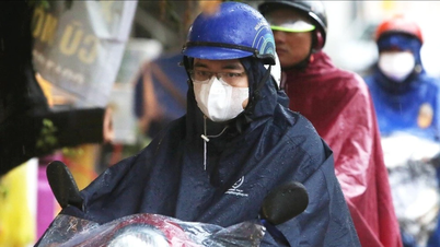
The Hydrometeorological Agency forecasts that on July 2, in the Northern region and Thanh Hoa, there will be moderate rain, heavy rain and thunderstorms, locally very heavy rain with common rainfall of 20-50mm, locally over 100mm.
On the night of July 2, the Northwest region and Thanh Hoa had moderate rain, heavy rain and thunderstorms, locally very heavy rain with common rainfall of 15-40mm, locally over 80mm.
Warning of risk of heavy localized rain (>100mm/6h).
In addition, on the day and night of July 2, the Central and Southern regions will have showers and thunderstorms, locally heavy rain with rainfall of 10-30mm, locally over 70mm (rain concentrated in the afternoon and evening).
From July 3, heavy rain in the North gradually decreased.
Thunderstorms may cause tornadoes, lightning, hail and strong gusts of wind. Heavy rain may cause flooding in low-lying areas, urban and industrial areas; flash floods on small rivers and streams; landslides on steep slopes.
Regarding the weather at sea, currently (July 2), the Gulf of Tonkin, the eastern sea area of the North East Sea (including Hoang Sa special zone); the central and southern East Sea area (including Truong Sa special zone), the sea area from Quang Tri to Ca Mau has showers and thunderstorms. In Con Dao special zone, there are southwest winds gusting to level 7.
Forecast for the day and night of July 2, the Gulf of Tonkin, the North East Sea (including Hoang Sa special zone), the Central and South East Sea (including Truong Sa special zone), the sea area from Quang Tri to Ca Mau, from Ca Mau to An Giang and the Gulf of Thailand will have scattered showers and thunderstorms. During thunderstorms, there is a possibility of tornadoes, strong gusts of wind level 6-7 and waves over 2.0m high.
In addition, in the sea area from Lam Dong to Ca Mau, there is strong southwest wind at level 5, sometimes level 6, gusting to level 7, waves from 1.5-2.5m high, rough sea.
All vessels operating in the above areas are at risk of being affected by tornadoes and strong gusts of wind.
Weather forecast for day and night 7/2:
Hanoi City
Cloudy, with rain, moderate rain and thunderstorms during the day, with some heavy rain in some places; showers and thunderstorms at night. Southeast wind level 2-3. Thunderstorms are likely to cause tornadoes, lightning and strong gusts of wind.
Lowest temperature: 23-25 degrees Celsius.
Highest temperature: 29-31 degrees Celsius.
Northwest
Cloudy with moderate to heavy rain and thunderstorms, locally very heavy rain. Light wind. Thunderstorms may cause tornadoes, lightning, hail and strong gusts of wind.
Lowest temperature: 22-25 degrees Celsius, some places below 22 degrees Celsius.
Highest temperature: 28-31 degrees Celsius, some places above 31 degrees Celsius.
Northeast
Cloudy, moderate rain, heavy rain and thunderstorms during the day, locally very heavy rain; scattered showers and thunderstorms at night, locally heavy rain. Southeast wind level 2-3. Thunderstorms are likely to cause tornadoes, lightning, hail and strong gusts of wind.
Lowest temperature: 22-25 degrees Celsius, mountainous areas below 22 degrees Celsius.
Highest temperature: 28-31 degrees Celsius, some places above 31 degrees Celsius.
Thanh Hoa - Hue
Cloudy, scattered showers and thunderstorms, locally heavy rain (rain concentrated in the afternoon and evening). Light wind. Thunderstorms may cause tornadoes, lightning and strong gusts of wind.
Lowest temperature: 24-27 degrees Celsius.
Highest temperature: 30-33 degrees Celsius, some places above 33 degrees Celsius.
South Central Coast
Cloudy, scattered showers and thunderstorms, locally heavy rain (rain concentrated in the afternoon and evening). Southwest wind level 2-3. Thunderstorms may cause tornadoes, lightning and strong gusts of wind.
Lowest temperature: 24-27 degrees Celsius.
Highest temperature: 32-35 degrees Celsius.
Central Highlands
Cloudy, scattered showers and thunderstorms; scattered showers and thunderstorms in the afternoon and evening, locally heavy to very heavy rain. Southwest wind level 2-3. Thunderstorms are likely to cause tornadoes, lightning and strong gusts of wind.
Lowest temperature: 20-23 degrees Celsius.
Highest temperature: 25-28 degrees Celsius, some places above 28 degrees Celsius.
Southern Vietnam
Cloudy, scattered showers and thunderstorms; scattered showers and thunderstorms in the afternoon and evening, locally heavy rain. Southwest wind level 2-3. Thunderstorms are likely to cause tornadoes, lightning and strong gusts of wind.
Lowest temperature: 24-27 degrees Celsius.
Highest temperature: 30-33 degrees Celsius, some places above 33 degrees Celsius.
Ho Chi Minh City
Cloudy, scattered showers and thunderstorms; scattered showers and thunderstorms in the afternoon and evening, locally heavy rain. Southwest wind level 2-3. Thunderstorms are likely to cause tornadoes, lightning and strong gusts of wind.
Lowest temperature: 25-27 degrees Celsius.
Highest temperature: 31-33 degrees Celsius.
Source: https://baophapluat.vn/thoi-tiet-ngay-27-mien-bac-mua-trang-troi-canh-bao-nguy-co-ngap-lut-post553803.html


![[Photo] General Secretary To Lam attends the launch of 3 digital platforms serving the implementation of Resolution No. 57-NQ/TW](https://vphoto.vietnam.vn/thumb/402x226/vietnam/resource/IMAGE/2025/7/2/d7fb7a42b2c74ffbb1da1124c24d41d3)


Comment (0)