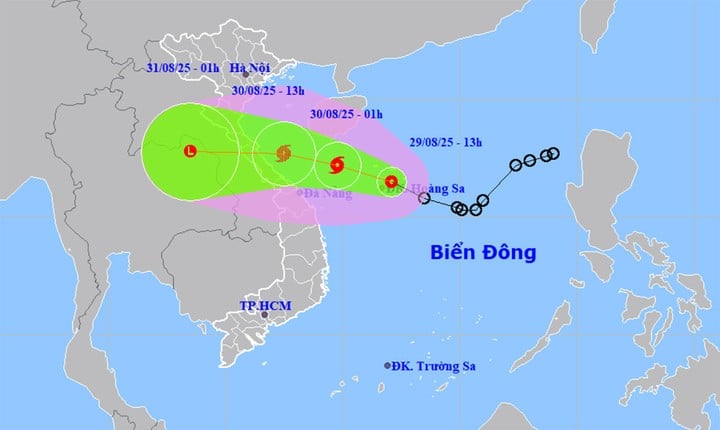
According to the National Center for Hydro-Meteorological Forecasting, early tomorrow morning, the tropical depression is likely to strengthen into a tropical depression. storm no. 6 In the East Sea, it is unlikely to strengthen to level 9. When moving into coastal waters, the tropical depression/storm is likely to weaken. Storm clouds are clearly shifting to the west, so from this afternoon, August 29, rain will gradually increase on the mainland and coastal areas of our country, with peak rain on the night of August 30 and morning of August 31.
At 1:00 p.m. on August 29, the center of the tropical depression was located in the Hoang Sa special zone, about 630 km east-southeast of Quang Tri and about 450 km east of Hue City. The strongest wind near the center of the tropical depression was level 7 (50-61 km/h), gusting to level 9, moving rapidly in the northwest direction at a speed of 20-25 km/h.

At about 1:00 a.m. on August 30, the tropical depression in the Quang Tri area reached Da Nang City, about 360 km east-southeast of Quang Tri, moving in the West-Northwest direction at a speed of about 20 km/h and strengthening into storm No. 6. The strongest wind near the storm was level 8, gusting to level 10.
At 1:00 p.m. the same day, storm No. 6 in the Nghe An sea area reached Hue city, the strongest wind near the storm center was level 8, gusting to level 10, moving in the West Northwest direction, traveling about 20km per hour.
Level 3 disaster risk warning in the western sea area of the North East Sea, the sea area from Thanh Hoa to Hue City (including Hon Ngu Island, Con Co special zone).
At 1:00 a.m. on August 31, storm No. 6 was on land in central Thailand, moving west at 20-25 km/h and weakening.
The impact of the tropical depression below may strengthen into a storm, the western sea area of the North East Sea (including Hoang Sa special zone) has strong winds of level 6-7, the area near the storm's center has strong winds of level 8, gusts of level 10, waves 2-5m high, rough seas.
From the night of August 29, the sea area from Thanh Hoa to Da Nang City (including Hon Ngu Island and Con Co Special Zone) will have heavy thunderstorms, winds gradually increasing to level 6-7, near the storm center it will be level 8, gusting to level 10, waves 2-4m high, near the storm center it will be 3-5m high, rough seas.
Coastal areas from Nghe An to Hue city have water levels rising from 0.2-0.4m.
"The weather at sea and in coastal areas is very dangerous and unsafe for vehicles and structures operating in dangerous areas such as cruise ships, passenger ships, transport ships, cages, rafts, and aquaculture areas," Meteorological agency warning.
On land, from noon on August 30, the coastal areas from Nghe An to Quang Tri will have strong winds of level 6, gusting to level 8. In particular, on the mainland, the coastal areas from Ha Tinh to Northern Quang Tri will have strong winds of level 6-7, in the area near eye of the storm level 8, level 10
From the night of August 29 to the end of August 31, Thanh Hoa to Hue city will have heavy to very heavy rain, rainfall ranging from 200-350mm, in some places over 600mm.
From August 30 to August 31, the midlands and deltas of the North and Da Nang city will have moderate rain, heavy rain, and locally very heavy rain with rainfall ranging from 100-200mm, in some places over 400mm.
Source: https://baolangson.vn/rang-sang-mai-ap-thap-nhet-doi-co-the-thanh-bao-bac-va-trung-bo-cao-diem-mua-5057491.html


![[Photo] President Luong Cuong receives Speaker of the New Zealand Parliament Gerry Brownlee](https://vphoto.vietnam.vn/thumb/1200x675/vietnam/resource/IMAGE/2025/8/29/7accfe1f5d85485da58b0a61d35dc10f)


Comment (0)