
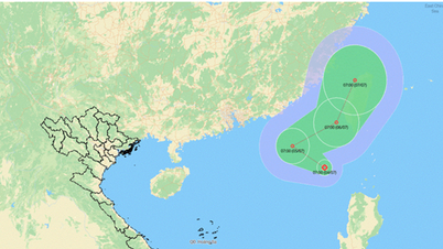
According to the National Center for Hydro-Meteorological Forecasting, at 10:00 a.m. this morning (July 4), the center of the tropical depression was at about 19.8 degrees North latitude; 118.8 degrees East longitude. The strongest wind near the center of the tropical depression was level 7 (50-61 km/h), gusting to level 9; moving slowly westward at a speed of 5-10 km/h.

It is forecasted that in the next 24 hours, the tropical depression will move northwest at 5-10km/h and is likely to strengthen into a storm. At 10am on July 5, the center of the tropical depression (likely to become a storm) is located in the northeastern part of the East Sea, with a level 8-9 intensity, gusting to level 11.
According to the wind level scale, level 8-9 will form a storm, with wind speeds of 61-68km/h and wave heights of 4-7m. Therefore, with this wind intensity forecast, this is likely to be the second storm in the East Sea during the 2025 storm season.
In the next 24 hours, the storm will change direction, moving northeast at a speed of 5-10km/h and is likely to strengthen. At 10am on July 6, the storm's center was still in the northeastern part of the East Sea, with a level 9-10 intensity, gusting to level 12.
In the next 48 to 72 hours, the tropical depression is likely to strengthen into a storm, continuing to move in a North-Northeast direction at a speed of about 20km/h.
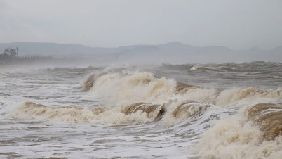
With the direction of the tropical depression moving, it is likely to strengthen into a storm, experts say it is unlikely to affect the mainland of our country. However, due to the impact of the storm/tropical depression, the northeastern sea area of the North East Sea will have thunderstorms and strong winds of level 6-7, then increase to level 8-9, gusting to level 11, very rough seas. Waves are 3-5m high. The sea area from Khanh Hoa to Ca Mau will have strong southwest winds of level 5, sometimes level 6, gusting to level 7, waves from 2-3m high, rough seas...
Ships operating in the above mentioned dangerous areas are susceptible to the effects of storms, whirlwinds, strong winds and large waves.
Source: https://baolaocai.vn/ap-thap-nhiet-doi-doi-huong-lien-tuc-kha-nang-manh-thanh-bao-trong-24-gio-toi-post647952.html


Comment (0)