

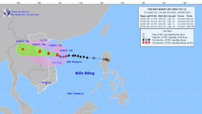
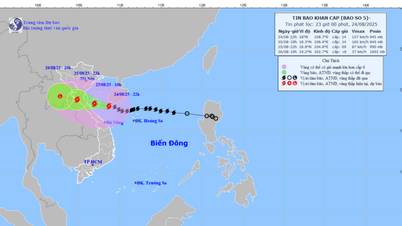
According to the National Center for Hydro-Meteorological Forecasting, on August 22, the low pressure area off the eastern coast of the Philippines strengthened into a tropical depression. By the afternoon of August 22, the center of the tropical depression was at about 16.8 degrees North latitude - 121.2 degrees East longitude, on the mainland of Luzon Island (Philippines).
The tropical depression is moving in the West Northwest direction at a speed of 10-15km/hour and is continuing to strengthen into storm No. 5.
 according to the model on the afternoon of August 22 of the National Center for Hydro-Meteorological Forecasting")
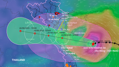
Forecast, on the afternoon of August 23, the center of the storm or tropical depression is about 520km east-northeast of Hoang Sa archipelago.
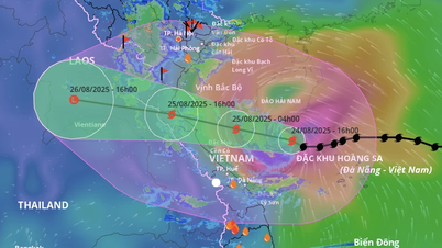
Meteorological experts warn that the storm is moving quite quickly in a West-Northwest direction, so there is a high probability of it making landfall in the North Central region. Response plans must be ready before August 24.
This afternoon, in Hanoi, Deputy Minister of Agriculture and Environment Nguyen Hoang Hiep chaired an urgent meeting to deploy response to the tropical depression developing into a storm.

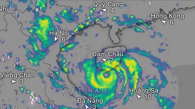
According to Mr. Mai Van Khiem, Director of the National Center for Hydro-Meteorological Forecasting, tonight, the tropical depression will enter the East Sea, becoming storm No. 5 (international name: Kajiki). When entering the East Sea, storm No. 5 will move quickly (about 20km/hour). On August 24, when moving to the Hoang Sa archipelago, the storm's intensity may reach level 10-11, gusting to level 13-14, and may even strengthen when moving into the Gulf of Tonkin. It is forecasted that around August 25, the storm will make landfall in our country.
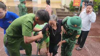
 were still heavily flooded due to the rain on August 21.")
Deputy Minister Nguyen Hoang Hiep requested the Department of Hydrometeorology and the National Center for Hydrometeorological Forecasting to forecast accurately and provide early information to local authorities to promptly direct response and avoid unfortunate incidents.
Source: https://www.sggp.org.vn/yeu-cau-du-bao-chinh-xac-bao-so-5-khong-de-xay-ra-su-co-dang-tiec-post809672.html


Comment (0)