

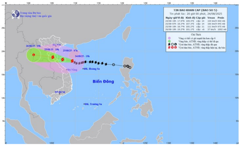
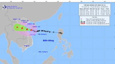
At 7:00 p.m. on August 24, the center of the storm was at approximately 17.9 degrees North latitude; 109.4 degrees East longitude, only about 410 km east-southeast of Nghe An province. Compared to the afternoon news of the same day, the storm had moved 60 km closer to the mainland.
The particularly dangerous point is that the storm has strengthened. The strongest wind near the storm's center is currently at level 14 (150-166 km/h), gusting to level 17. The storm continues to move west at a speed of about 15-20 km/h and is likely to strengthen further.
Forecasting the trajectory and time of storm landfall
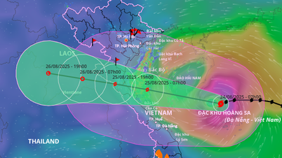
- At 7:00 a.m. on August 25: The center of the storm was located at approximately 18.2 degrees North latitude; 107.3 degrees East longitude, right on the southern Gulf of Tonkin, only about 200km from Nghe An. At this time, the storm still maintained its terrifying strength at level 14, gusting to level 17.
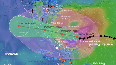
- At 7:00 p.m. on August 25: The eye of the storm is located on the Vietnam - Laos border. When it makes landfall, the storm weakens to level 10-11, gusting to level 14.
- Then the storm continued to deepen and gradually weaken.
The level of natural disaster risk in coastal areas from Thanh Hoa to Quang Tri and on land in these provinces is warned at level 4 - very high level.
Warning of extremely dangerous impacts on land and sea
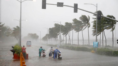
- On land: The forecast has been adjusted to a more dangerous direction. From early morning on August 25, on land in Nghe An province, the wind will gradually increase to level 12-14, gusting to level 15-16. This is an extremely destructive wind level, which can cause disaster if not prevented.
- At sea: Nghe An sea area (including Hon Ngu island) has strong winds of level 13-14, gusting to level 17; waves from 8.0-10.0m high near the storm center. The sea is very rough. Coastal areas are at risk of storm surges from 0.5-1.8m high, causing deep flooding in low-lying areas.
- Heavy rain: From the night of August 24 to the end of August 26, Nghe An is likely to experience heavy to very heavy rain, with rainfall ranging from 200-400mm in general and over 600mm in some places. Special precautions should be taken against heavy rain (over 150-200mm in 3 hours) which can cause flash floods and landslides.
Source: https://baonghean.vn/tin-bao-moi-nhat-bao-so-5-manh-len-cap-14-giat-cap-17-chi-con-cach-nghe-an-khoang-400-km-10305132.html


Comment (0)