


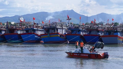
According to the report of the Provincial Civil Defense Command, as of 8:00 p.m. on August 24, coastal communes at high risk of being affected when storm No. 5 makes landfall have evacuated 4,577 households with nearly 12,104 people to safety.
Among them, the communes with a large number of evacuated households include: Thien Cam commune evacuated 1,456 households/4,393 people; Dan Hai commune 1,132 households/3,755 people; Dong Tien commune 250 households/517 people; Hoanh Son ward 171 households, 458 people...
For communes and wards at risk of flooding, flash floods, and landslides, local authorities have also reviewed and evacuated 390 households/875 people.
Specifically, Ky Hoa commune evacuated 97 households/156 people; Son Kim 2 commune evacuated 69 households/213 people; Phuc Trach commune 21 households/58 people; Son Kim 1 commune evacuated 12 households/28 people; Vu Quang commune 9 households/21 people; Cam Binh commune 149 households/303 people; Bac Hong Linh ward 33 households/96 people.
Currently, localities continue to review to direct and concentrate forces to support the evacuation of people from dangerous areas to safe shelters.
In cases where people are in areas at high risk of being unsafe when storm No. 5 makes landfall but refuse to evacuate, local authorities will organize enforcement and take people to shelters.

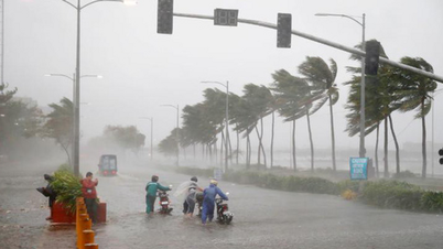
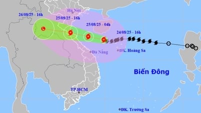
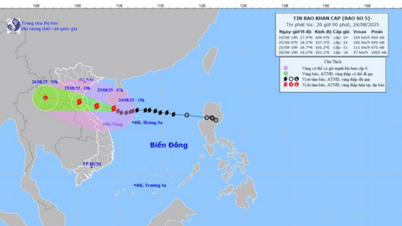
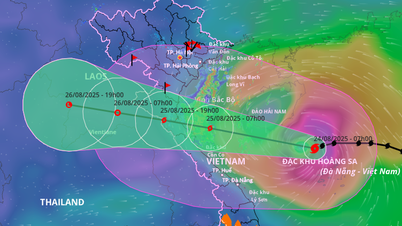
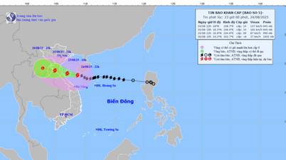
Storm No. 5 with strong intensity is moving inland. Ha Tinh is in the area directly affected when the storm makes landfall. The sea in Ha Tinh has winds gradually increasing to level 7 - 9, then increasing to level 10 - 12, near the storm's center level 13 - 14, gusting to level 17; waves 5 - 7m high, near the center 8 - 10m, rough seas.
The coastal area of Ha Tinh has storm surges of 0.5 - 1.8m. The water level at Cua Nhuong (Ha Tinh) is 2.2 - 2.6m high. There is a high risk of flooding in low-lying coastal and river mouth areas due to surges and big waves in the afternoon and evening of August 25.
The weather at sea and in coastal areas during storms is extremely dangerous and unsafe for any vehicles or structures operating in dangerous areas such as: cruise ships, passenger ships, cargo ships, cages, rafts, aquaculture areas, dykes, embankments, coastal routes. Vehicles are highly likely to capsize, be destroyed, or be flooded due to strong winds, large waves, and rising sea levels.
From early morning on August 25, on land, winds gradually increased to level 8 - 11, gusting to level 12 - 14. Particularly in the Northern Ha Tinh area, winds were strong at level 12 - 14, gusting to level 15 - 16.
Due to the impact of storm No. 5, from the night of August 24 to the end of August 26, Ha Tinh province will have heavy to very heavy rain and thunderstorms. Total rainfall in common areas is 200 - 400 mm, some places over 600 mm (heavy rain concentrated from early morning of August 25 to evening of August 25). Warning of the risk of heavy rain (>200 mm/3 hours).
.
Source: https://baohatinh.vn/ha-tinh-so-tan-gan-13000-nguoi-dan-vung-nguy-hiem-toi-noi-an-toan-post294310.html


Comment (0)