


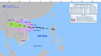
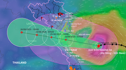
The National Center for Hydro-Meteorological Forecasting reported that at 6 p.m. on August 24, storm No. 5 had strengthened to level 14 (150-166 km/h), gusting to level 17, moving in a West-Northwest direction with a speed reduced to about 15 km/h.
Previously, the storm was at level 12 on the morning of August 24 and strengthened to level 13 early this afternoon. The basic direction of movement today is west. Thus, after only 2 hours, the storm has increased by 1 level and tends to change direction.
The center of the storm at 6 p.m. was at about 17.8 degrees North latitude - 109.6 degrees East longitude, about 435km from Nghe An, 410km from Ha Tinh and 360km from Quang Tri to the East.
The Department of Meteorology and Hydrology ( Ministry of Agriculture and Environment ) informed that the meteorological agency is currently issuing warning information every hour about storm number 5 .
 updated at 6:00 p.m. on August 24. Source: ZOOM EARTH")
8 localities simultaneously issued a ban on the sea
The Department of Dyke Management and Natural Disaster Prevention (Ministry of Agriculture and Environment) informed that up to this point, 8 coastal provinces and cities from Ninh Binh to Quang Ngai have issued a sea ban, requiring all boats to stop going to sea to avoid risks.
More than 675,000 people in coastal and low-lying areas from Thanh Hoa to Da Nang have been prepared to evacuate to safety before the landfall.
 braced and protected equipment before storm No. 5 swept through. Photo: HOANG LINH")
 on the afternoon of August 24. Photo: Provided by the Department of Meteorology and Hydrology")

. Photo: HOANG LINH")
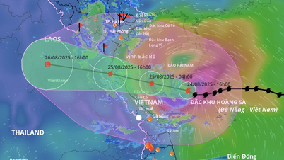
Large storm cloud disk - forecasted rain in some places over 700mm
The National Center for Hydro-Meteorological Forecasting warns that in the next 24-48 hours , the storm will continue to maintain its strong intensity as it approaches land, causing widespread heavy rain.
Rainfall is generally 200-400mm, with areas from Thanh Hoa to Northern Quang Tri experiencing particularly heavy rain, exceeding 700mm. The meteorological agency warns of a high risk of flash floods, landslides and inundation in the North Central and Northern provinces, along with the possibility of tornadoes, lightning and strong gusts of wind during thunderstorms.
Heavy rains are forecast to last until August 26 , then gradually decrease, but low-lying areas and the dyke system will continue to be under great pressure. Coastal localities need to proactively protect the safety of people, infrastructure works and agricultural production, including nearly 300,000 hectares of rice, more than 77,000 hectares of fruit trees and 57,000 hectares of rubber at risk.
Source: https://www.sggp.org.vn/bao-so-5-da-dat-muc-cuong-phong-post809973.html


Comment (0)