


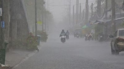
Bad weather forecast for our country due to the impact of storm No. 5 (Photo: HONG QUANG)
The National Center for Hydro-Meteorological Forecasting said that today, August 24, the weather in the Northwest will have scattered showers and thunderstorms, with heavy rain in some places.
Northeast, Hue and Da Nang have scattered showers and thunderstorms, some places have heavy rain. From tonight, the coastal areas of the North will have moderate rain and scattered thunderstorms, some places have heavy to very heavy rain.
From Thanh Hoa to Quang Tri, scattered showers and thunderstorms, heavy rain in some places. Very heavy rain from tonight.
Southern region and other areas have scattered showers and thunderstorms. Heavy rain in some places in the evening. Thunderstorms may have tornadoes, lightning, hail and strong gusts of wind.
At sea, today storm No. 5 is active, causing very bad weather. The North East Sea (including Hoang Sa special zone) has strong winds of level 8-9, near the storm's eye level 10-13, gusting to level 15, waves 5-7m high, near the storm's eye 7-9m, rough seas.
From noon and afternoon, the sea area from Thanh Hoa to Hue City (including Hon Ngu Island, Con Co Special Zone) has winds gradually increasing to level 6-8, then increasing to level 9-10, the area near the storm center has levels 11-13, gusts of level 15, waves 4-6m high, the area near the storm center has 7-9m, the sea is very rough.
From this afternoon, the northern part of the Gulf of Tonkin (including Cat Hai, Co To, and Van Don special economic zones) will have winds gradually increasing to level 6-7, gusting to level 9. Particularly, the southern part of the northern Gulf of Tonkin (including Bach Long Vi special economic zone) will have strong winds of level 8, gusting to level 10, waves 2-4m high, and rough seas.
Coastal areas from Ninh Binh to northern Quang Tri have storm surges of 0.5 - 1.5m. Water levels in Sam Son (Thanh Hoa) are 3.3 - 3.8m high, in Hon Ngu (Nghe An) are 3.5 - 4m high, in Vung Ang (Ha Tinh) are 2.5 - 3m high and in Cua Gianh (Quang Tri) are 1.5 - 2m high. There is a high risk of flooding in low-lying coastal areas, river mouths, and islands from Thanh Hoa to northern Quang Tri.
The weather at sea and in coastal areas during storms is extremely dangerous and unsafe for any ships or structures operating in the danger zone.
Detailed weather forecast today August 24:
Hanoi is cloudy, with showers and thunderstorms. Lowest temperature 25-27 degrees Celsius, highest 31-33 degrees Celsius.
The Northwest region is cloudy with scattered showers and thunderstorms, with heavy rain in some places. The lowest temperature is 23-26 degrees Celsius, the highest is 30-33 degrees Celsius.
Northeast region has clouds, showers and thunderstorms, heavy rain in some places. Lowest temperature 24-27 degrees Celsius, highest 30-33 degrees Celsius.
From Thanh Hoa to Hue, there will be clouds, scattered showers and thunderstorms, heavy rain in some places. Lowest temperature 24-27 degrees Celsius, highest 30-33 degrees Celsius.
South Central Coast has clouds, scattered showers and thunderstorms, heavy rain in some places in the evening. Lowest temperature 24-27 degrees Celsius, highest 30-33 degrees Celsius.
Central Highlands cloudy, scattered showers and thunderstorms, heavy rain in the evening. Lowest temperature 20-23 degrees Celsius, highest 25-28 degrees Celsius.
Southern region has clouds, scattered showers and thunderstorms, heavy rain in the evening. Lowest temperature 23-26 degrees Celsius, highest 29-32 degrees Celsius.
Ho Chi Minh City is cloudy, with showers and thunderstorms in some places, heavy rain in the evening. Lowest temperature 24-27 degrees Celsius, highest 30-32 degrees Celsius./.

Weather forecast today August 24 (Graphics: NGOC THANH)
According to Tuoi Tre Newspaper
Source: https://tuoitre.vn/thoi-tiet-hom-nay-24-8-tu-bac-bo-den-da-nang-mua-rat-to-bien-dong-bao-du-20250823202107105.htm
Source: https://baolongan.vn/thoi-tiet-hom-nay-24-8-tu-bac-bo-den-da-n-ng-mua-rat-to-bien-dong-bao-du-a201250.html

![[Photo] Many people eagerly await the preliminary review despite heavy rain](https://vphoto.vietnam.vn/thumb/1200x675/vietnam/resource/IMAGE/2025/8/27/4dc782c65c1244b196890448bafa9b69)


![[Photo] Brilliant red of the exhibition 95 years of the Party Flag lighting the way before the opening](https://vphoto.vietnam.vn/thumb/1200x675/vietnam/resource/IMAGE/2025/8/27/e19d957d17f649648ca14ce6cc4d8dd4)


Comment (0)