

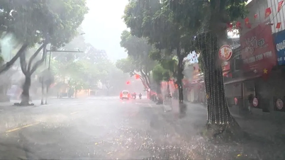
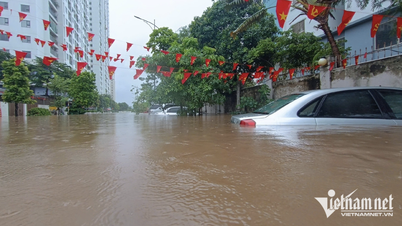
On August 27, heavy rain continued in the midlands, deltas and coastal areas of the North. (Photo: Duy Khuong/VNA)

According to the National Center for Hydro-Meteorological Forecasting, on the night of August 26 and early morning of August 27, the midlands and deltas of the North, Lao Cai, Thanh Hoa, Hue city, Da Nang and the eastern part of Quang Ngai province will have moderate rain, heavy rain, and locally very heavy rain.
Rainfall from 7pm on August 26 to 3am on August 27 was over 90mm in some places.
Typically Cam Phuc (Hai Phong) 166.6mm; Trau Quy ( Hanoi ) 93mm; Van Giang (Hung Yen) 93mm; Thanh Tan (Thanh Hoa) 110mm; Khe La (Nghe An) 103.8mm; Tra Nham (Quang Ngai) 150.8mm; Nui Thanh (Da Nang) 134.6mm...
It is forecasted that from early morning to noon on August 27, the midlands, plains and coastal areas of the North, Son La, Lao Cai , Thanh Hoa will have moderate rain, heavy rain and thunderstorms. Total rainfall is generally 20-40 mm; locally over 100 mm.
Rain mainly from early morning to noon on August 27. Warning of heavy rain intensity of 90 mm/3 hours.
In addition, on the day and night of August 27, other places in the North, from Nghe An to Lam Dong and the South, will have scattered showers and thunderstorms. Rainfall is generally from 10-30 mm; locally over 80 mm (concentrated in the afternoon and night). Warning of rain intensity greater than 70 mm/3 hours.
Thunderstorms may bring tornadoes, lightning, hail, and strong gusts of wind. From the afternoon of August 27, heavy rain in the Northern region will gradually decrease.
Level 1 natural disaster risk - heavy rain, tornadoes, lightning, hail. Heavy rain can cause flooding in low-lying areas, urban areas and industrial zones; flash floods on small rivers and streams; landslides on steep slopes. During thunderstorms, there is still a possibility of tornadoes, lightning, hail and strong gusts of wind.
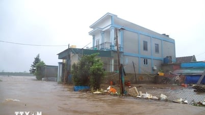
At the same time, the National Center for Hydro-Meteorological Forecasting also warned that floods on Thao River (Lao Cai), Luc Nam River (Bac Ninh), Hoang Long River (Ninh Binh), downstream Ma River (Thanh Hoa), and Ca River (Nghe An) are rising slowly.
In the next 3-6 hours, flood on Thao River in Yen Bai will peak at 0.4m above alert level 3 and then decrease.
In the next 6-12 hours, the flood downstream of Ma River will peak above alert level 3 at 0.3m; the flood on Luc Nam River will peak above alert level 2 at 0.2m, then decrease.
In the next 12-24 hours, flood on Thao River will drop to alert level 1, downstream Ma River will drop to alert level 2-3; flood on Luc Nam River will drop below alert level 1.
On August 27, the flood on Hoang Long River peaked at 0.3 m above alert level 3 and then decreased. The flood downstream of Ca River fluctuated above alert level 1.
High risk of flooding in low-lying areas along rivers, flash floods on small rivers and streams and landslides on steep slopes in the provinces of Lao Cai, Phu Tho, Bac Ninh, Ninh Binh, Thanh Hoa, Nghe An
Currently (August 27), the tropical convergence zone has an axis through the North East Sea connecting with the low pressure area in the East of the Philippines, at 1:00 a.m. it is located at about 15.5-16.5 degrees North latitude and 119.5-120.5 degrees East longitude. At Hon Ngu station (Nghe An), there are gusts of level 8; at Phu Quy station (Lam Dong), there are strong winds of level 6, gusts of level 7.
Forecast for the day and night of August 27, the sea area from Lam Dong to Ho Chi Minh City, the central East Sea area, the northern sea area of the southern East Sea area (including the sea area north of Truong Sa archipelago) will have southwest wind level 6, gusting level 7-8; rough sea. Wave height 2-3.5 m, southwest direction.
In addition, other sea areas including the Gulf of Tonkin, the sea area from South Quang Tri to Ca Mau, Ca Mau to Kien Giang, the Gulf of Thailand, the Northern, Central and Southern areas of the East Sea (including the Hoang Sa and Truong Sa archipelagos) will have scattered showers and thunderstorms. During thunderstorms, there is a possibility of tornadoes, strong gusts of wind of level 6-7 and waves over 2m high. Strong winds, rough seas.
During the day and night of August 28, the sea area from Lam Dong to Ho Chi Minh City, the area between the East Sea and the northern sea area of the South East Sea (including the sea area north of Truong Sa archipelago) will continue to have strong southwest winds of level 6, gusting to level 7-8; waves 2-3.5 m high; rough seas.
All vessels operating in the above areas are advised to be at high risk of being affected by tornadoes, strong winds and large waves.
According to the National Center for Hydro-Meteorological Forecasting, on the day and night of August 27, areas across the country will continue to have rain, some places will have localized heavy rain, accompanied by thunderstorms, whirlwinds and strong gusts of wind.
Specific forecast for regions day and night 8/27
Hanoi area
- The lowest temperature is commonly 24-26 degrees Celsius; the highest is 27-29 degrees Celsius.
- Cloudy, moderate rain, heavy rain and thunderstorms, locally very heavy rain; heavy rain gradually decreases from the afternoon. Southeast to East wind level 2-3. During thunderstorms, there is a possibility of tornadoes, lightning and strong gusts of wind.
Northwest
- Lowest temperature 21-24 degrees Celsius, some places below 21 degrees Celsius; highest 26-29 degrees Celsius.
- Cloudy with scattered showers and thunderstorms, locally heavy to very heavy rain. Light wind. Warning of risk of tornadoes, lightning, hail and strong gusts of wind in thunderstorms.
Northeast
- Lowest temperature 22-25 degrees Celsius; highest 27-30 degrees Celsius, some places over 30 degrees Celsius.
- Cloudy, scattered showers and thunderstorms, locally heavy rain. Plains and coastal areas have moderate rain, heavy rain, scattered thunderstorms; locally very heavy rain. Heavy rain gradually decreases from the afternoon. Southeast to East wind level 2-3. During thunderstorms, tornadoes, lightning and strong gusts of wind may occur.
Provinces from Thanh Hoa-Hue
- Lowest temperature 23-26 degrees Celsius; highest 28-31 degrees Celsius.
- Cloudy, scattered showers and thunderstorms, locally heavy rain; Thanh Hoa has moderate rain, heavy rain and thunderstorms, some places have very heavy rain. Light wind. Warning of tornadoes, lightning and strong gusts of wind in thunderstorms.
South Central Coast Region
- Lowest temperature 24-27 degrees Celsius; highest 31-34 degrees Celsius.
- Cloudy, scattered showers and thunderstorms, locally heavy rain. Southwest wind level 2-3. Thunderstorms may cause tornadoes, lightning, hail and strong gusts of wind.
Central Highlands region
- Lowest temperature 19-22 degrees Celsius; highest 27-30 degrees Celsius, some places over 30 degrees Celsius.
- Cloudy, scattered showers and thunderstorms, locally heavy rain, concentrated in the afternoon and night. Southwest wind level 2-3. Warning of risk of tornadoes, lightning, hail and strong gusts of wind in thunderstorms.
Southern Region
- Lowest temperature 23-26 degrees Celsius; highest 29-32 degrees Celsius, some places above 32 degrees Celsius.
- Cloudy, scattered showers and thunderstorms, locally heavy rain, concentrated in the afternoon and evening. Southwest wind level 2-3. Thunderstorms are likely to cause tornadoes, lightning, hail and strong gusts of wind.
Ho Chi Minh City
- Lowest temperature 24-26 degrees Celsius; highest 30-32 degrees Celsius.
- Cloudy, scattered showers and thunderstorms, locally heavy rain in the afternoon and evening. Southwest wind level 2-3. Be careful of dangerous weather phenomena such as tornadoes, lightning, hail and strong gusts of wind during thunderstorms./.
According to Vietnamplus
Source: https://www.vietnamplus.vn/thoi-tiet-ngay-278-mua-lon-tiep-dien-o-khu-vuc-dong-bang-va-ven-bien-bac-bo-post1058162.vnp
Source: https://baolongan.vn/thoi-tiet-ngay-27-8-mua-lon-tiep-dien-o-khu-vuc-dong-bang-va-ven-bien-bac-bo-a201431.html
![[Photo] Many people eagerly await the preliminary review despite heavy rain](https://vphoto.vietnam.vn/thumb/1200x675/vietnam/resource/IMAGE/2025/8/27/4dc782c65c1244b196890448bafa9b69)


![[Photo] Brilliant red of the exhibition 95 years of the Party Flag lighting the way before the opening](https://vphoto.vietnam.vn/thumb/1200x675/vietnam/resource/IMAGE/2025/8/27/e19d957d17f649648ca14ce6cc4d8dd4)

![[Photo] Prime Minister Pham Minh Chinh chairs meeting of National Steering Committee on International Integration](https://vphoto.vietnam.vn/thumb/1200x675/vietnam/resource/IMAGE/2025/8/26/9d34a506f9fb42ac90a48179fc89abb3)


![[Photo] General Secretary To Lam attends Meeting with generations of National Assembly deputies](https://vphoto.vietnam.vn/thumb/402x226/vietnam/resource/IMAGE/2025/8/27/a79fc06e4aa744c9a4b7fa7dfef8a266)


Comment (0)