

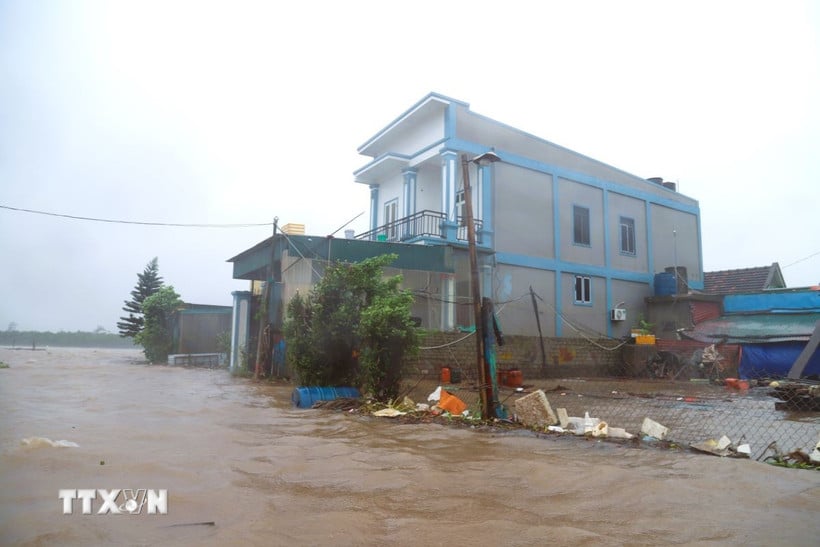
Residential areas near Lach Van estuary in Ngoc Minh hamlet (Dien Chau commune, Nghe An province) are heavily flooded due to rising sea levels. (Photo: Xuan Tien/VNA) |
According to the National Center for Hydro-Meteorological Forecasting, early on the morning of August 26, storm No. 5 weakened into a tropical depression in Central Laos.
Low pressure center at 18.9 degrees North-104.5 degrees East (Central Laos). Strongest wind level 7 (50-61 km/h), gust level 9; moving West Northwest at 15-20 km/h.
Previously, many coastal stations in Nghe An and Ha Tinh recorded strong winds of level 8-10, gusts of 12-15; water levels rose 1.66m at Hon Ngu and 1.01m at Sam Son.
In the Northern Delta provinces, from Thanh Hoa to Quang Tri , there has been moderate to heavy rain, and in some places very heavy rain over 600mm.
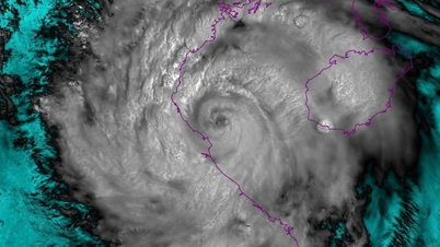
Location and path of the tropical depression. (Source: National Center for Hydro-Meteorological Forecasting) |
Forecast, by 4:00 p.m. on August 26, the low pressure area at 19.3 degrees North - 102.1 degrees East (Central Laos) will weaken into a low pressure area below level 6. The dangerous area is around 17.0 - 20.5 degrees North; West 108.5 degrees East. Risk level 3 (Gulf of Tonkin).
At sea, this morning (August 26), in the Gulf of Tonkin (Bach Long Vi, Cat Hai, Co To, Van Don, Hon Ngu) there are winds of level 6-7, gusts of 8, waves of 2-5m, and rough seas.
On land, Thanh Hoa-Nghe An provinces, coastal Ninh Binh wind level 6-7, gust 9.
From early morning of August 26 to the end of August 26, the midlands and deltas of the North, Lao Cai, Son La, Thanh Hoa, Ha Tinh will have rain from 50-100mm, some places more than 200mm, with a risk of heavy rain with an intensity of more than 100mm/3 hours.
Some areas such as Hanoi have heavy rain with thunderstorms; Da Nang has no rain; Ho Chi Minh City has showers and thunderstorms in the evening.
From early morning of August 26-27, the Upper and Central Laos regions had 100-250mm of rain, locally over 500mm.
In the next 6 hours, there is a risk of flash floods, landslides, and land subsidence on steep slopes and small streams in Lang Son, specifically in areas such as: Bang Mac, Bac Son, Binh Gia, Chau Son, Chi Lang, Chien Thang, Diem He, Dinh Lap, Hong Phong, Hung Vu, Huu Lien, Khuat Xa, Kien Moc, Nhan Ly, Nhat Hoa, Quan Son, Quy Hoa, Tan Doan, Tan Tri, Tan Van, Thai Binh, Thien Hoa, Thien Long, Thien Thuat, Thong Nhat, Tri Le, Van Linh, Van Quan, Vu Lang, Xuan Duong, Yen Binh, Yen Phuc.
According to the National Center for Hydro-Meteorological Forecasting, due to the influence of the southern edge of the low pressure trough combined with the southwest monsoon operating at medium to strong intensity, the specific weather in areas across the country during the day and night of August 26 is as follows:
Hanoi area is cloudy with moderate rain, heavy rain and thunderstorms; locally very heavy rain. Southeast wind level 2-3. During thunderstorms, there is a possibility of tornadoes, lightning and strong gusts of wind. Lowest temperature from 23-25 degrees Celsius, highest from 27-29 degrees Celsius.
The Northwest region is cloudy with rain, moderate rain and scattered thunderstorms; in Lao Cai and Son La, there will be moderate rain, heavy rain and thunderstorms, locally very heavy rain. Light wind. During thunderstorms, there is a possibility of tornadoes, lightning, hail and strong gusts of wind. The lowest temperature is from 21-24 degrees Celsius, in some places below 21 degrees Celsius; the highest is from 26-29 degrees Celsius.
The Northeast region is cloudy, the midlands and plains have moderate rain, heavy rain and scattered thunderstorms, locally very heavy rain; mountainous areas have rain, moderate rain, some places have heavy rain and thunderstorms. Southeast wind level 2-3, Ninh Binh in the morning has strong wind level 6-7, gusting to level 9. During thunderstorms, there is a possibility of tornadoes, lightning and strong gusts of wind. The lowest temperature is from 22-25 degrees Celsius; the highest is from 26-29 degrees Celsius.
Provinces from Thanh Hoa to Hue are cloudy, with scattered showers and thunderstorms, locally heavy rain; especially in the area from Thanh Hoa to Ha Tinh, there will be moderate rain, heavy rain, and very heavy rain in some places. In the North, the Southeast wind, in the South, the Southwest wind level 2-3; especially in Thanh Hoa and Nghe An, there will be strong winds level 6-7 in the morning, gusting to level 9. During thunderstorms, beware of tornadoes, lightning, and strong gusts of wind. The lowest temperature is from 23-25 degrees Celsius; the highest is from 28-31 degrees Celsius, with some places above 31 degrees Celsius.
In the South Central Coast, it is cloudy, sunny during the day, with scattered showers and thunderstorms in some places; scattered showers and thunderstorms in the evening, with heavy rain in some places. Southwest wind level 2-3. During thunderstorms, there is a possibility of tornadoes, lightning, hail and strong gusts of wind. The lowest temperature is from 24-27 degrees Celsius; the highest is from 31-34 degrees Celsius, with some places above 34 degrees Celsius.
The Central Highlands region is cloudy, with intermittent sunshine during the day, with scattered showers and thunderstorms in some places; scattered showers and thunderstorms in the afternoon and evening, with some heavy rain in some places. Southwest wind level 2-3. During thunderstorms, there is a possibility of tornadoes, lightning, hail and strong gusts of wind. The lowest temperature is from 19-22 degrees Celsius; the highest is from 27-30 degrees Celsius.
Southern provinces have scattered showers and thunderstorms; in the afternoon and evening, there will be scattered showers and thunderstorms, with some places having heavy rain. Southwest wind level 2-3. During thunderstorms, there is a possibility of tornadoes, lightning, hail and strong gusts of wind. The lowest temperature is from 23-26 degrees Celsius; the highest is from 29-32 degrees Celsius, with some places above 32 degrees Celsius.
Ho Chi Minh City is cloudy with scattered showers and thunderstorms; scattered showers and thunderstorms in the afternoon and evening, with some heavy rain in some places. Southwest wind level 2-3. During thunderstorms, there is a possibility of tornadoes, lightning, hail and strong gusts of wind. Temperature ranges from 24-32 degrees Celsius.
The National Center for Hydro-Meteorological Forecasting warns that heavy rains concentrated in the Northern, North Central and Central Highlands regions pose a risk of flash floods, landslides in mountainous areas and localized flooding in low-lying areas. People are advised to monitor the next weather forecasts and warnings to proactively respond./.
According to vietnamplus.vn
Source: https://huengaynay.vn/chinh-tri-xa-hoi/bao-so-5-suy-yeu-mua-lon-khap-dong-bang-bac-bo-co-noi-mua-rat-to-tren-600mm-157103.html

![[Photo] Prime Minister Pham Minh Chinh chairs meeting of National Steering Committee on International Integration](https://vphoto.vietnam.vn/thumb/1200x675/vietnam/resource/IMAGE/2025/8/26/9d34a506f9fb42ac90a48179fc89abb3)
![[Photo] Prime Minister Pham Minh Chinh receives CEO of Samsung Electronics](https://vphoto.vietnam.vn/thumb/1200x675/vietnam/resource/IMAGE/2025/8/26/373f5db99f704e6eb1321c787485c3c2)
![[Photo] Multi-colored cultural space at the Exhibition "80 years of the journey of Independence - Freedom - Happiness"](https://vphoto.vietnam.vn/thumb/1200x675/vietnam/resource/IMAGE/2025/8/26/fe69de34803e4ac1bf88ce49813d95d8)


Comment (0)