

On the afternoon of August 24, in Hanoi, the Department of Meteorology and Hydrology ( Ministry of Agriculture and Environment ) held a press conference to provide information on the developments of storm No. 5.

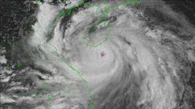
Mr. Hoang Phuc Lam, Deputy Director of the National Center for Hydro-Meteorological Forecasting, said that the climate conditions in the East Sea are currently very favorable for the storm to develop and maintain its strong intensity. The sea surface temperature is above 30°C, the currents are stable, and the storm's trajectory is mainly over the sea, so it is less obstructed.
Mr. Hoang Phuc Lam said that according to current analysis, the trajectory of storm No. 5 is almost entirely over the sea, not blocked by islands, so its intensity remains stable and has the potential to continue to strengthen.
“This morning the storm was at level 12, and by the afternoon it had increased to level 13. We believe the storm could reach level 14, and some sources even predict it will reach level 15,” informed Mr. Hoang Phuc Lam.

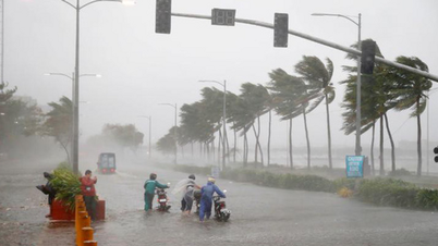
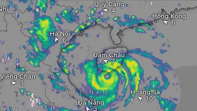
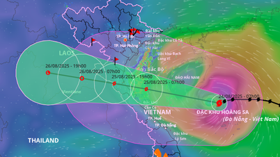
The storm cloud band is very wide, covering many areas of the Central and Northern regions. The focus of strong winds is forecast to be concentrated in Nghe An, Ha Tinh and northern Quang Tri. Thanh Hoa, Nghe An and Ha Tinh are warned of a high risk of flash floods and landslides.

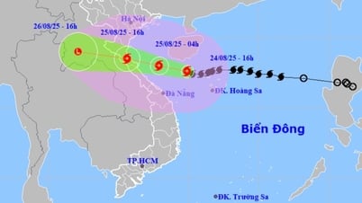
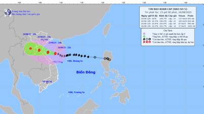
According to the meteorological agency, storm No. 5 is moving at a speed of 15-20km/h, sometimes reaching 25km/h. In just two days, from when it strengthened into a storm on the night of August 22 to the afternoon of August 24, the storm's intensity has increased by 7 levels, currently reaching level 13 and continuing to strengthen.
The Deputy Director of the National Center for Hydro-Meteorological Forecasting added that tonight the storm could reach level 13-14, and some forecasts even predict it could reach level 15 when it makes landfall. The storm is expected to directly affect Nghe An , Ha Tinh and Quang Tri provinces from noon to afternoon on August 25.

However, the storm's wide circulation is forecast to cause widespread rain. On the afternoon of August 24, the northwest circulation edge of storm No. 5 began causing moderate to heavy rain in the Northern Delta region, including Hanoi.

Updated at 5:00 p.m. on August 24, the storm center was at about 17.6 degrees North latitude - 109.9 degrees East longitude, 470km from Nghe An, 450km from Ha Tinh and 390km from Quang Tri to the East; strong winds of level 13-14, gusting to level 16, moving at a speed of 20km/hour in a westerly direction as it moves towards the mainland of our country.
The meteorological agency recommends that localities urgently complete response work, reinforce houses, harvest crops, reinforce structures, and evacuate people from dangerous areas before 10 p.m. tonight, August 24. "From tomorrow morning, the wind will be very strong, and all activities will be almost impossible," Mr. Hoang Phuc Lam noted.
In addition, right after storm Kajiki, there is a possibility of a new tropical depression appearing in the East Sea.
Source: https://www.sggp.org.vn/canh-bao-bao-kajiki-tang-7-cap-dat-suc-gio-nguy-hiem-ngang-bao-yagi-post809962.html


Comment (0)