
Specifically, Mr. Huynh Van Loi - Deputy Director of the Department of Culture and Sports of Binh Dinh province said that the People's Committee of this province has agreed in principle to assign the Department to preside over and coordinate with the People's Committee of Hoai Nhon town, the People's Committee of An Lao district and related units to survey and build a profile of the Truong Luy Binh Dinh relic to submit to the Ministry of Culture, Sports and Tourism to request the policy of ranking it as a national relic according to regulations.
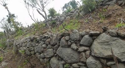
Binh Dinh Longwall runs through An Lao district and Hoai Nhon town for more than 14km. Photo: Binh Dinh
"The construction of a dossier to propose the national relic ranking of the Truong Luy section in Binh Dinh aims to protect and promote the value of the relic, create more unique cultural tourism products to attract tourists, and contribute to the development of tourism in the province," said Mr. Loi.
According to information from Binh Dinh Museum, Truong Luy is the name of a rampart about 147 km long, built under the Nguyen Lords and completed in the 19th century, also known as the Quan Thuong road.
The Great Wall was built of earth and stone, located to the east of the Truong Son mountain range, stretching from Tra Bong district ( Quang Ngai ) to An Lao district (Binh Dinh).
According to documents, the Quang Ngai - Binh Dinh Wall is a typical heritage of Vietnam. The Wall began to be built around the 16th century, when Mr. Bui Ta Han (1496 - 1568) took charge of the Le Trung Hung Dynasty to govern Quang Nam, now the land of Da Nang City and the provinces of Quang Nam, Quang Ngai, Binh Dinh, Phu Yen.
At that time, to prevent the minorities in the west of Quang Ngai, he built earthen ramparts in dangerous places and set up some forts/fortresses to guard them.
At the end of the Gia Long period and the beginning of the Minh Mang period, in an effort to stabilize the western highlands, the Nguyen Dynasty court agreed to the request of Le Van Duyet (1764 - 1832), a great mandarin and a military general from Bo De village, Mo Hoa district (now Mo Duc district, Quang Ngai), allowing the mobilization of human resources to reinforce and connect the sections of the Long Luy together, building more forts/fortresses, forming a continuous system of forts and ramparts, spanning the western part of Quang Ngai province, running from Ha Dong district (now Tam Ky city, Quang Nam) to the north of Quy Nhon district (now Bong Son and An Lao districts, Binh Dinh province). From here, this long rampart was named Tinh Man Long Luy.
Currently, the section of Truong Luy located in Quang Ngai province was ranked as a national monument in 2011. The section of Truong Luy located in Binh Dinh province, more than 14 km long, stretching from La Vuong village, Hoai Son commune (Hoai Nhon town) to An Lao town and An Hung, An Tan, An Quang communes (belonging to An Lao district), has not been ranked.
Source: https://www.congluan.vn/binh-dinh-de-nghi-xep-hang-truong-luy-la-di-tich-quoc-gia-post313927.html


Comment (0)