

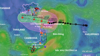
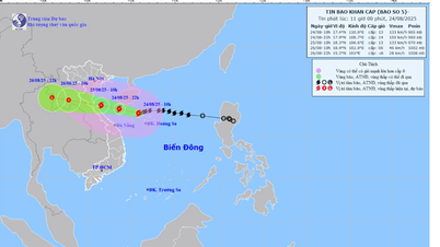
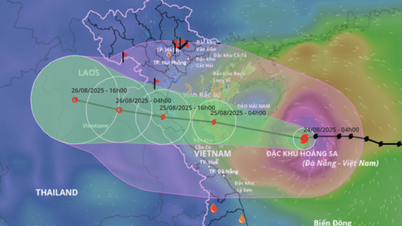
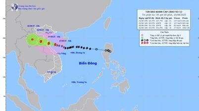
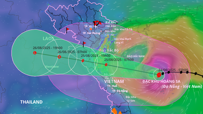
The National Center for Hydro-Meteorological Forecasting said that at 7am today, the storm was in the northwest sea of Hoang Sa special zone, about 620km from Nghe An, about 600km east of Ha Tinh , with the strongest wind speed of 133km/h, level 12, gusting to 15.
Heading northwest at a speed of 20 km/h, it is forecasted that by 7am tomorrow, the storm will be in the southern Gulf of Tonkin, 160 km from Nghe An and 140 km from Ha Tinh, level 12-13, gusting to 15.
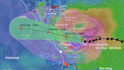
The storm center will then move into Nghe An - Ha Tinh tomorrow afternoon. The meteorological agency determined the natural disaster risk at level 4 on a scale of 5 for coastal waters of Thanh Hoa - Quang Tri , on land Thanh Hoa - northern Quang Tri. The Gulf of Tonkin, the sea area south of Quang Tri - Hue (including Hon Ngu island, Con Co special zone) is level 3.

The Japan Meteorological Agency forecasts that the storm is currently at 126 km/h, and will continue to increase to 144 km/h today. The Hong Kong station gave a similar assessment of the intensity, and that the storm's center will move between Nghe An and Ha Tinh.
Due to the storm's influence, the northwestern East Sea (including Hoang Sa special zone) has strong winds of level 8-10, near the storm's eye level 11-13, gusts of 15, waves 5-7 m high, near the storm's eye 7-9 m.
From noon and afternoon today, the sea area of Thanh Hoa - Hue (including Hon Ngu island, Con Co special zone) will gradually increase in wind to level 6-8, then increase to level 9-10, the area near the storm's center will be level 11-13, gusting to level 15, waves 4-6 m high, the area near the center will be 7-9 m.
In the northern part of the Gulf of Tonkin (including Cat Hai, Co To, and Van Don special economic zones), the wind gradually increases to level 6-7, gusting to level 9; in the southern part of the Gulf of Tonkin (including Bach Long Vi special economic zone), the wind increases to level 8, gusting to level 10; waves are 2-4 m high.
Coastal areas and islands in the Hai Phong - Ha Tinh region will have storm surges of 0.5-1.5 m. Water levels at Hon Dau monitoring station (Hai Phong) are 3.3-3.8 m, Ba Lat (Ninh Binh) 1.7-2.1 m, Sam Son (Thanh Hoa) 3.2-3.7 m, Hon Ngu (Nghe An) 3.2-3.6 m, Cua Nhuong (Ha Tinh) 2.2-2.6 m. There is a high risk of flooding in low-lying coastal areas and river mouths due to surges and big waves tomorrow evening.
The meteorological agency warns that the weather at sea and in coastal areas during the storm is extremely dangerous, unsafe for any vehicles or structures operating in the dangerous area. Vehicles are at high risk of capsizing and being destroyed; flooding due to strong winds, big waves and rising sea levels.

On land from tonight, Thanh Hoa - Quang Tri will have winds gradually increasing to level 7-9, near the storm center level 10-12, gusting to level 14-15; coastal areas of Quang Ninh - Ninh Binh will have winds gradually increasing to level 6-7, gusting to level 8.
Heavy rain due to the storm will start from tonight until August 26, the Northern Delta, southern Phu Tho and Thanh Hoa - Hue will have widespread rain of 100-150 mm, locally 250 mm; Thanh Hoa - northern Quang Tri will have rain of 200-400 mm, locally over 700 mm. There is a risk of heavy rain over 200 mm in three hours.
From August 25-26, Hanoi and Da Nang will have thunderstorms. Upper and Central Laos will have 100-250 mm, Central Laos will have some places with over 500 mm.

The Prime Minister yesterday issued a telegram requesting coastal provinces from Quang Ninh to Gia Lai to proactively prevent storms at the highest level, ensuring safety and lives for the people. Four working groups led by the Ministry of Agriculture and Environment and the Ministry of National Defense are going to Thanh Hoa, Nghe An, Ha Tinh, and Quang Tri to coordinate with localities in directing storm response.
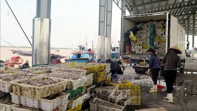
Currently, coastal provinces from Ninh Binh to Thua Thien Hue have banned the sea, not allowing boats to go out to sea. Boats returning to shelters are being arranged to anchor to avoid collisions and sinking. Since yesterday, localities have proactively released water from hydroelectric and irrigation reservoirs to ensure the safety of the reservoirs, reducing the risk of deep flooding due to post-storm rains. The authorities are reviewing and preparing to evacuate people in low-lying areas at risk of landslides.
Kajiki is the fifth storm to appear in the East Sea this year. The storm formed from a low pressure area in the Philippines' Luzon Island, then quickly strengthened into a tropical depression and a typhoon when it entered the East Sea on July 23.
Source: https://baolaocai.vn/bao-kajiki-manh-len-cap-12-huong-nghe-an-ha-tinh-post880366.html


Comment (0)