


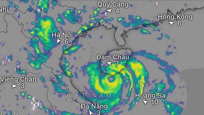
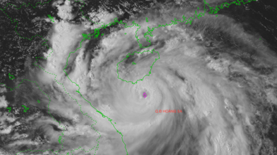
Satellite cloud image at 7am this morning shows a very wide storm circulation (Photo: NCHMF)
On the morning of August 24, Mr. Mai Van Khiem, Director of the National Center for Hydro-Meteorological Forecasting, provided the latest information on the developments of storm No. 5 as well as the time the storm will make landfall in our country.
According to Mr. Khiem, early this morning, storm number 5 has strengthened to level 12 (118-133km/h), gusting to level 15.
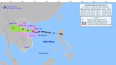
Currently, the storm is about 600km east southeast of Nghe An - Ha Tinh .
"The intensity of storm No. 5 is forecast to continue to increase in the next 12 to 24 hours, possibly even reaching level 14 (150-166km/h), gusting to level 15-16," said Mr. Khiem.
Mr. Khiem said there are many factors that have helped storm number 5 continuously increase in intensity since yesterday until now and will continue to strengthen.
First, the formation and movement of storms over warm seas with water temperatures above 30 degrees Celsius. These are favorable conditions for storms to nurture energy and develop.
Second, the storm forms on the tropical convergence zone, where the east to northeast and southwest winds converge. This wind circulation system creates heat and momentum for the storm to increase rapidly in intensity.

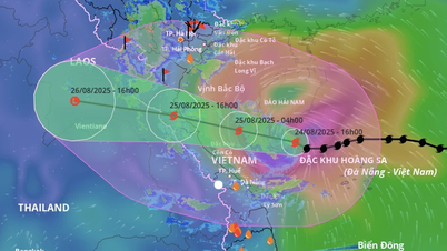
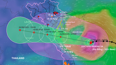
Forecast of location and direction of storm No. 5 at 4:00 a.m. on August 24 (Photo: NCHMF)
Regarding the time the storm impacts and makes landfall, Mr. Khiem said that it is forecasted that from tonight, on the mainland of the coastal provinces of Thanh Hoa - Quang Tri, the storm winds may gradually become stronger.
"The storm is expected to make landfall around noon to tomorrow afternoon (August 25). Storm No. 5 will cause a combination of many impacts.
For the sea route, the storm causes strong to extremely strong winds up to level 12-13, gusts of level 15-16, waves 5-7m high, near the storm center up to 8-9m. With such strong winds and large waves, it is extremely dangerous for ships, boats, and rafts at sea, even large tonnage ships can be sunk.
For the mainland, there are also strong winds up to level 11-12, gusting to level 13-14, even gusting to level 15. With such strong winds, infrastructure, houses... if not guaranteed can be affected, greatly impacted.
The storm's circulation also caused widespread heavy rain in the North Central and Northern regions, with some areas experiencing up to 600-700mm of rain. Therefore, there is a very high risk of flooding, flash floods, and landslides," said Mr. Khiem.
Regarding the recommendations, Mr. Khiem emphasized that people should not be subjective because in the past, thunderstorms occurred before storms causing great damage, along with the problem of heavy rain before, during and after storms causing flooding, flash floods and landslides./.
According to Tuoi Tre Newspaper
Source: https://tuoitre.vn/bao-so-5-khi-nao-do-bo-vao-dat-lien-viet-nam-20250824072737941.htm
Source: https://baolongan.vn/bao-so-5-khi-nao-do-bo-vao-dat-lien-viet-nam-a201252.html


Comment (0)