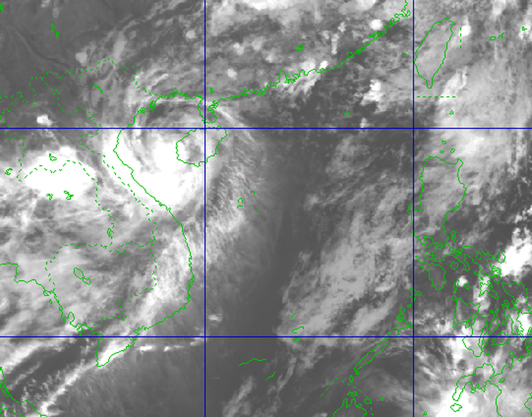
Latest images of storm number 1
At 9:00 p.m. on June 13, the center of the storm was at approximately 19.0 degrees North latitude; 108.6 degrees East longitude, approximately 200 km South-Southeast of Bach Long Vi Island. Strongest wind: Level 11 (103-117 km/h), gusting to level 14.
Forecast in the next 3 hours, the storm will move in the North-Northeast direction, speed about 10-15km/h. Then the storm will continue to move in the North-Northeast direction, entering the Leizhou peninsula (China), gradually weakening.
With the path of storm No. 1 like this, coastal areas need to pay attention: Ships operating in the Gulf of Tonkin, offshore waters from Quang Tri to Da Nang and the Northwest of the East Sea should avoid going to sea because they may be affected by strong winds of level 7-9, areas near the storm's center will be level 10-12, gusts of level 14, waves 4-6m high, and rough seas. In addition, there is a possibility of being affected by thunderstorms, whirlwinds, strong winds, and large waves.
In the Gulf of Tonkin (including Co To and Bach Long Vi island districts), the waves are 2.0-4.0m high, especially in the East 4.0-6.0m, the sea is very rough.
Northwest of the North East Sea and offshore waters from Quang Tri to Da Nang, waves are 3.0-5.0m high, near the storm center, waves are 4.0-6.0m high, seas are very rough.
The Hai Phong - Nghe An sea area is likely to experience high sea levels (Hon Dau: 3.9m, Hon Ngu: 2.8m) causing local flooding in some low-lying areas along the coast and river mouths.
According to Mr. Mai Van Khiem, Director of the National Center for Hydro-Meteorological Forecasting, heavy rain in the Central Central region in June with common rainfall of 250-400mm, especially in the provinces from Quang Tri-Da Nang, the total rainfall in 3 days is commonly from 300-650mm, some places are higher: Nam Dong (Hue): 768mm. Notably, in Nam Dong: 559mm on June 12, 2025 is rare,
According to statistics, there are 32 automatic rain gauge stations with accumulated rainfall in 6 hours of over 200mm, especially in Hue and Da Nang areas, in which the largest rainfall in 6 hours at Bach Ma station in Loc Tri Commune, Phu Loc District, Thua Thien Hue Province was 319.4mm.
In particular, in Hue, the rainfall on June 12 was over 800 mm in some places. Specifically, from the night of June 10 to the morning of June 13, there was very heavy rain in Hue city. The rainfall on June 11 was generally 50-250 mm, on June 12 it was generally 220-670 mm, in Bach Ma (Phu Loc) it was 884.2 mm, on June 13 it was generally 50-265 mm.
Rare high flood in June
On the current flood situation on the rivers of the Central region: From On the night of June 11-13, a flood occurred on rivers from South Quang Binh to Quang Nam. Up to now, the flood peak on Thach Han River (Quang Tri), Bo River (Hue City) is at level BĐ3; Huong River (Hue City), Vu Gia River (Quang Nam) is 0.1-0.15m higher than BĐ2. Only Kien Giang River (Quang Binh) is still rising slowly and at a high level. The water level at 13:00/June 13, at Le Thuy station was 2.77m, 0.07m above BĐ3.
Deep flooding occurred in the districts of Bo Trach, Quang Ninh, Le Thuy (Quang Binh), Hai Lang, Cam Lo, Trieu Phong, Gio Linh, Dong Ha city (Quang Tri); Phong Dien, Quang Dien, Phu Loc, Phu Vang (Hue city).
Forecast: In the next 12 hours, the flood on Kien Giang River will continue to rise slowly and be 0.2-0.3m higher than BĐ3, then decrease. Flooding in Le Thuy district will last for the next 2-3 days.
In the next 12-24 hours, floods on other rivers from Quang Binh to Quang Nam will fluctuate at level 1-2 and above level 2. Flooding in the provinces will gradually decrease.
Mr. Mai Van Khiem said: "The recent flood in the Central Central provinces was a rare high flood in June; the flood peaks on Kien Giang River, Thach Han River, Bo River, and Vu Gia River were the highest flood peaks in the past 30 years."
It is forecasted that from now until the end of the year, the number of storms/tropical depressions in the East Sea and making landfall in our country is likely to be approximately the average (average in the East Sea is about 11-13 storms, making landfall about 5-6 storms). Storms/tropical depressions are likely to be concentrated in the period from July to September in the North and October to November and will greatly affect the Central region and the Southern provinces.
Thu Cuc
Source: https://baochinhphu.vn/bao-so-1-suy-yeu-dan-de-phong-ngap-lut-tai-cac-tinh-mien-trung-102250613222158469.htm

















Comment (0)