

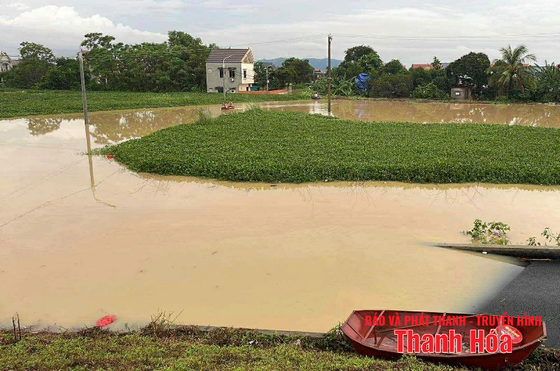
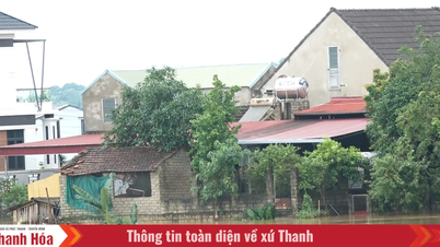
The rising water level of the Ma River has caused many riverside areas to be deeply flooded. (Photo: Nam Nam)
Water levels at 7:00 a.m. on August 27 on some rivers in Thanh Hoa province were as follows: Buoi River at Kim Tan hydrological station 12.76m, above BĐIII: 0.76m; Chu River at Xuan Khanh station 9.65m, above BĐI: 0.65m; Ma River at Ly Nhan hydrological station 11.87m, below BĐIII: 0.13m, at Giang hydrological station 6.62m, above BĐIII: 0.12m.
It is forecasted that in the next 6-12 hours, the flood on the downstream of Ma River will fall below level BĐIII; in the next 12-24 hours, it will continue to fall and stay above level BĐII.
Warning of high risk of flooding in many communes and wards in the province, including: Tay Do, Vinh Loc, Bien Thuong, Quy Loc, Yen Truong, Yen Dinh, Dinh Tan, Dinh Hoa, Thieu Quang, Hoang Giang, Hoang Loc, Hoang Chau, Hoang Thanh, Dong Tien, Ham Rong, Hac Thanh, Quang Phu, Nguyet Vien, Sam Son, Tay Do, Vinh Loc, Kim Tan, Thach Binh, Nong Cong, Thang Binh, Truong Van, Trung Chinh, Thang Loi, Tuong Linh, Quang Chinh, Tien Trang, Quang Yen, Quang Ngoc, Ngoc Son, Cac Son, Dong Son, Tho Lap, Xuan Tin, Xuan Lap, Thieu Hoa, Thieu Tien, Thieu Quang, Yen Dinh, Yen Phu, Yen Ninh, Dinh Hoa.
Regarding rain, today, August 27, Thanh Hoa area continues to have moderate rain, heavy rain and thunderstorms, with common rainfall from 20-50mm, locally very heavy rain over 100mm. Risk of localized heavy rain over 90mm/3 hours.
NM
Source: https://baothanhhoa.vn/lu-tren-song-ma-dang-o-muc-dinh-du-bao-xuong-duoi-bao-dong-iii-trong-6-12-gio-toi-259700.htm


![[Photo] Images of the State-level preliminary rehearsal of the military parade at Ba Dinh Square](https://vphoto.vietnam.vn/thumb/1200x675/vietnam/resource/IMAGE/2025/8/27/807e4479c81f408ca16b916ba381b667)


![[Photo] Parade blocks pass through Hang Khay-Trang Tien during the preliminary rehearsal](https://vphoto.vietnam.vn/thumb/1200x675/vietnam/resource/IMAGE/2025/8/27/456962fff72d40269327ac1d01426969)


Comment (0)