

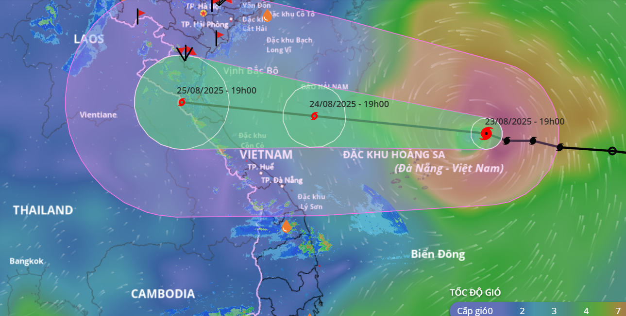
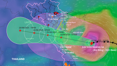
Storm No. 5's movement direction from Vietnam's natural disaster monitoring system, at 7:00 p.m. on August 23.
The strongest wind near the storm center is level 10 (89-102km/h), gusting to level 12; moving in the West Northwest direction at a speed of 20-25km/h.
At 7:00 p.m. on August 24, the storm moved in a West-Northwest direction at a speed of 20-25 km/h and continued to strengthen. The center of the storm was located at 18, 1N109, 2E; in the sea south of Hainan Island (China), intensity 12-13, gust level 15.
At 7:00 p.m. on August 25, the storm moved in the West Northwest direction, at a speed of 15-20 km/h, with gusts of level 11 and 13 on land from Thanh Hoa to Northern Quang Tri .
At 7:00 p.m. on August 26, the storm moved in a West-Northwest direction at a speed of 15-20 km/h and gradually weakened into a low pressure area over the mainland of Upper Laos.
In the North East Sea (including Hoang Sa special zone), there are strong winds of level 8-9, near the storm center level 10-13, gusts of level 15, waves 5.0-7.0m high, near the storm center 7.0-9.0m, rough seas.
From noon and afternoon of August 24, the sea area from Thanh Hoa to Hue City (including Hon Ngu Island, Con Co Special Zone) will have winds gradually increasing to level 6-8, then increasing to level 9-10, near the storm center level 11-13, gusting to level 15; waves 4.0-6.0m high, near the center 7.0-9.0m; rough seas.
From the afternoon of August 24, the North of Bac Bo Gulf (including the special zones: Cat Hai, Co To, Van Don) has winds gradually increasing to level 6-7, gusting to level 9; the South of the North of Bac Bo Gulf (including the special zone Bach Long Vi) has strong winds of level 8, gusting to level 10; waves 2.0-4.0m high; rough seas.
Coastal areas from Ninh Binh to Northern Quang Tri have storm surges of 0.5-1.5m high. Water levels in Sam Son (Thanh Hoa) are 3.3-3.8m high, in Hon Ngu (Nghe An) are 3.5-4.0m high, in Vung Ang ( Ha Tinh ) are 2.5-3.0m high and in Cua Gianh (Quang Tri) are 1.5-2.0m high. There is a high risk of flooding in low-lying coastal areas, river mouths, and islands from Thanh Hoa to Northern Quang Tri.
From the night of August 24, on land from Thanh Hoa to Quang Tri, winds will gradually increase to level 7-9, near the storm center, level 10-12, gusting to level 14-15; coastal areas from Quang Ninh to Ninh Binh, winds will gradually increase to level 6-7, gusting to level 8.
From the night of August 24 to the end of August 26, in the Northern Delta, South Phu Tho and from Thanh Hoa to Hue City, there is a possibility of widespread heavy rain with common rainfall of 100-150mm, locally over 250mm; in particular, the area from Thanh Hoa to North Quang Tri will have heavy to very heavy rain with common rainfall of 200-400mm, locally over 700mm. Warning of the risk of heavy rain (>200mm/3 hours).
LP
Source: https://baothanhhoa.vn/bao-so-5-manh-cap-10-giat-cap-12-cach-dac-khu-hoang-sa-220km-259179.htm


Comment (0)