

Typhoon Kajiki (typhoon No. 5) is forecast to be very strong, have a very wide range of influence, move very quickly, and be especially dangerous. Domestic and international forecasting agencies have predicted that the typhoon will make landfall directly on our country's mainland with strong intensity.
On August 23 and 24, the Ministry of Industry and Trade issued an urgent dispatch on emergency response to the storm. The Departments of Industry and Trade of provinces and cities were requested to direct hydropower dam owners to strengthen protection of dams and reservoirs; operate according to procedures, lower water levels to welcome floods; coordinate warnings, and ensure safety for people.
In particular, hydropower projects in areas likely to be affected by storms (especially in the provinces of Thanh Hoa, Nghe An, Ha Tinh , Quang Tri, Thua Thien Hue) proactively increase power generation, water discharge, and lower reservoir water levels below pre-flood levels to increase flood capacity, contributing to cutting and reducing floods downstream.
The Department of Industry and Trade of provinces and cities must also ensure the supply and storage of essential goods for people in areas isolated by floods. Strengthen market inspection, strictly handle speculation, hoarding, and unreasonable price increases, especially for construction materials and essential goods...

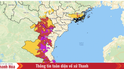
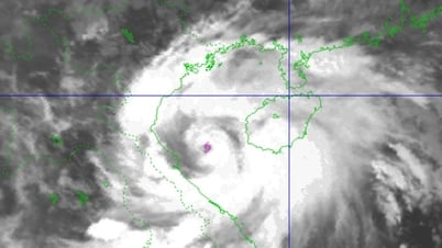
Storm Kajiki will make landfall in the Nghe An - Quang Tri mainland area at noon and afternoon on August 25 (Photo: NCHMF).
Hydropower dam owners must strictly follow reservoir operation procedures, absolutely not allow artificial floods to occur and notify people in advance before releasing floodwaters. At the same time, it is necessary to strengthen inspections and promptly fix problems in dams, flood discharge equipment, warning systems, ensuring safety for dams, downstream areas and works under construction.
The Ministry of Industry and Trade also requested large hydropower plants and reservoirs in the Central region such as Trung Son, Hua Na, Ban Ve, Huong Dien, etc. to closely monitor meteorological forecasts and proactively lower water levels from August 23-27 to increase flood capacity and reduce pressure on downstream areas when storm No. 5 makes landfall.
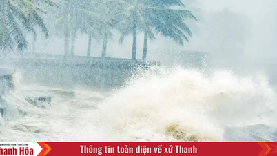
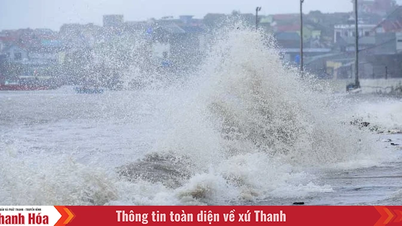
The National Center for Hydro-Meteorological Forecasting said that at 6 p.m. on August 24, storm Kajiki had strengthened to level 14 (150-166 km/h), gusting to level 17, about 435 km from Nghe An, about 410 km east-southeast of Ha Tinh, and about 360 km east of northern Quang Tri.
In terms of danger level, storm No. 5 is assessed to be not much less dangerous than storm Yagi 2024 in terms of strong winds, and at least equal to, or possibly even stronger than, storm No. 10 in 2017, which caused severe damage in the Ha Tinh area.
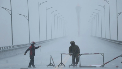
Therefore, the National Center for Hydro-Meteorological Forecasting has raised the warning level to level 4 - a very high level. People and local authorities need to respond urgently and decisively, evacuate when required and absolutely not be subjective.
Source: https://dantri.com.vn/kinh-doanh/bao-kajiki-duoc-du-bao-cuong-do-manh-bo-cong-thuong-chi-dao-khan-20250825001825291.htm

![[Photo] Images of the State-level preliminary rehearsal of the military parade at Ba Dinh Square](https://vphoto.vietnam.vn/thumb/1200x675/vietnam/resource/IMAGE/2025/8/27/807e4479c81f408ca16b916ba381b667)


![[Photo] Parade blocks pass through Hang Khay-Trang Tien during the preliminary rehearsal](https://vphoto.vietnam.vn/thumb/1200x675/vietnam/resource/IMAGE/2025/8/27/456962fff72d40269327ac1d01426969)


Comment (0)