
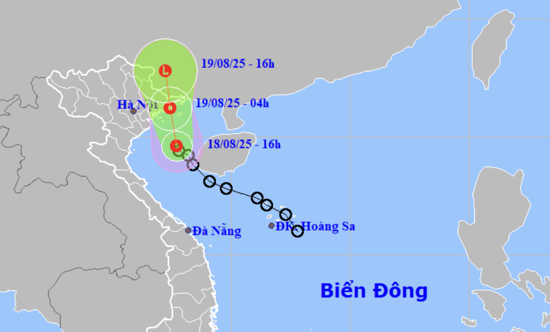
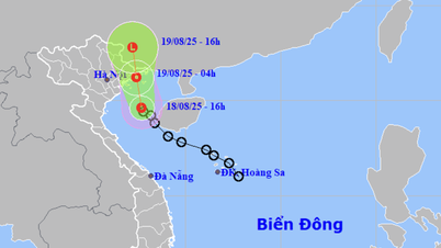
Forecast of location and direction of tropical depression at 4:00 p.m. August 18 - Photo: NCHMF
On the afternoon of August 18, Mr. Nguyen Van Huong, head of the weather forecast department, National Center for Hydro-Meteorological Forecasting, said that at 4:00 p.m. this afternoon, the center of the tropical depression was about 45km south of Bach Long Vi Island ( Hai Phong ).
The strongest wind near the center of the tropical depression is level 6-7 (39-61km/h), gusting to level 9.
Due to the influence of tropical depression, at Bach Long Vi and Quang Ha stations ( Quang Ninh ), strong winds of level 6, gusts of level 7 were observed, and at Co To station (Quang Ninh), strong winds of level 6, gusts of level 8 were observed.
It is forecasted that in the next 12 to 24 hours (from early tomorrow morning), the tropical depression will likely make landfall in Quang Ninh and Hai Phong.
"We estimate that from this evening to tomorrow morning, the tropical low pressure circulation will cause strong winds of level 6-7, gusting to level 9 in the Gulf of Tonkin (including the special zones of Bach Long Vi, Cat Hai, Co To and Van Don).
On land, due to the influence of the tropical low pressure circulation, in the coastal areas of Quang Ninh and Hai Phong, there are strong winds of level 6, gusting to level 8.
The tropical depression is also likely to cause widespread moderate to heavy rain in the northeastern provinces and Thanh Hoa from this afternoon until the end of tomorrow with common rainfall of 50-150mm, in some places very heavy rain over 300mm" - Mr. Huong said.
Regarding the areas with heavy rain, Mr. Huong said that the coastal areas of Quang Ninh, Hai Phong, Hung Yen, Ninh Binh, Thanh Hoa provinces will have the heaviest rain from tonight to tomorrow afternoon.
Wisdom - Tuoitre.vn
Source: https://tuoitre.vn/ap-thap-nhiet-doi-kha-nang-do-bo-vao-quang-ninh-hai-phong-ven-bien-gio-manh-20250818172225947.htm


![[Photo] Prime Minister Pham Minh Chinh attends the opening ceremony of the National Data Center](https://vphoto.vietnam.vn/thumb/1200x675/vietnam/resource/IMAGE/2025/8/18/b5724a9c982b429790fdbd2438a0db44)


Comment (0)