
 |
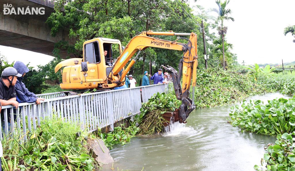
| Hoa Tho Dong Ward (Cam Le District, Da Nang City) mobilized forces and vehicles to collect trash and dredge floodwaters. Photo: DNO |
Along with that, the flood has flooded 90,511 hectares of rice and crops (Ha Tinh 630 hectares, Quang Binh 21,254 hectares, Quang Tri 24,908 hectares, Hue 25,247 hectares, Quang Nam 16,741 hectares, Da Nang 1,731 hectares). By the morning of June 14, the provinces and cities of Quang Nam and Da Nang had stopped flooding, other areas were receding, the flood level had decreased; 2,380 hectares of aquaculture were damaged due to flooding and washing away (Quang Binh 1,553 hectares, Quang Tri 745 hectares, Da Nang 33 hectares, Quang Nam 49 hectares).
In Quang Binh province, there are 34 flooded and cut-off traffic routes (National Highways 9B, 15, 12A; Provincial Roads 564, 565D, 562, 558B, 559B and rural traffic routes); 14 landslides (National Highways 9E, 12A, 9B, 9C; Provincial Roads 561, 558C, 562). By 07:00 on June 14, 2025, the flood water had basically receded and traffic was normal; there are currently 2 flooded locations (Ca Roong spillway connecting Ca Roong 2 village to Ban Ca Roong is still flooded about 1m deep; Water at the Sung tree culvert (Km 17 Provincial Road 562) recedes slowly, traffic is not yet impassable).
Quang Tri province is flooded in some locations on National Highways 15D, 49C, 1, 9; Provincial Roads 571, 576C, 578b, 582, 584, 586, 587, 588a and some rural roads. Currently, the water on National Highways 15D, 9, DT.571, DT.576C, DT.578b, DT.584, DT.586, DT.587 and urban roads has receded, traffic has returned to normal; National Highways 49C are still flooded in some sections causing traffic jams, DT.588a section of Ba Long Spillway Bridge - Km11+240, is still flooded 50cm.
Hue City flooded some locations on provincial roads 4, 4B, 5, 6, 10, 12D, 12B, 15B, 17B, 19, 25B, 49B and rural roads in Phong Dien and Quang Dien districts; Landslides on the slopes of road 14C, La Son - Tuy Loan road, Phu Loc district and National Highway 49 (km 67+200), Ho Chi Minh road (km 350+185), A Luoi district. Currently, the landslide locations have been fixed and traffic is smooth.
Da Nang City has 38 locations on traffic routes that have landslides and minor damage, but traffic is now clear.
Floods have sunk or damaged 8 ships (Quang Binh 2 ships operating at sea, 1 ship anchored at the port; Da Nang 5 ships anchored at the port).
According to information from the Border Guard Standing Agency, as of 6:00 a.m. on June 14, the authorities have notified, counted, and instructed 53,792 vehicles/223,054 people to know the developments and direction of the storm to proactively avoid it, specifically: Activities in the Gulf of Tonkin (from Quang Ninh to Quang Binh) are 1,754 ships/6,114 people (mainly operating along the coast); activities in other areas are 1,182 ships/9,816 people; anchoring at ports is 50,856 ships/207,124 people.
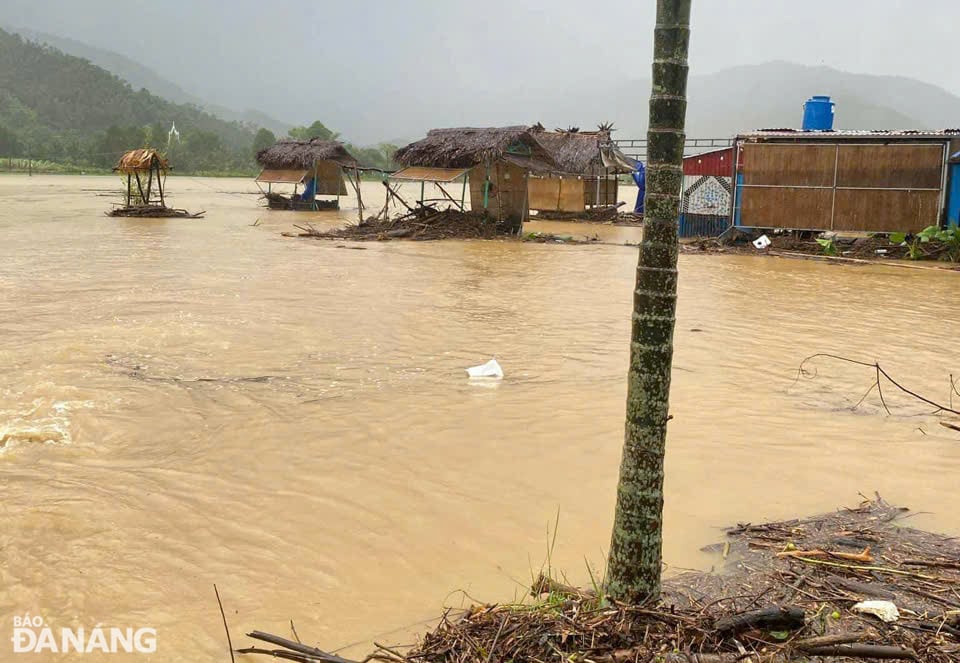 |
| Many agricultural production areas and tourism facilities in Hoa Bac commune, Hoa Vang district, Da Nang city were flooded. Photo: DNO |
To continue to respond to storm No. 1 and the flood situation, which is assessed by the Hydrometeorological Agency as complicated in the coming time, the Department of Dyke Management and Natural Disaster Prevention and Control (Ministry of Agriculture and Environment) to the coastal provinces and cities from Quang Ninh to Quang Ngai, Kon Tum, Gia Lai continue to proactively respond to storm No. 1 and floods according to Official Dispatch No. 86/CD-TTg dated June 10 of the Prime Minister and the direction of Deputy Minister of Agriculture and Environment Nguyen Hoang Hiep at the meeting to deploy response to storm No. 1 and floods on June 11.
In particular, it is necessary to continue to urgently notify, count, and guide ships to anchorage or escape from dangerous areas; ensure safety of ships, security, and order in anchorage areas; for provinces from Quang Binh to Quang Nam, mobilize forces to support people to overcome the consequences of rain and floods, and soon stabilize their lives and production.
Provinces and cities in the Central, Central Highlands and Southern regions proactively respond to heavy rains, risks of floods, inundation, flash floods and landslides according to Document No. 2992/BNNMT-DD dated June 10, 2025 of the Ministry of Agriculture and Environment.
Localities organize serious on-duty shifts and regularly report to the Ministry of Agriculture and Environment (through the Department of Dyke Management and Disaster Prevention and Control).
In the face of the damage caused by floods, on the morning of June 14, authorities in localities in Quang Binh province are mobilizing more forces and expanding the search area for 4 missing victims due to floods in Minh Hoa and Bo Trach districts (Quang Binh). At the same time, on the morning of June 14, the rain has stopped, the Department of Agriculture and Environment of Quang Binh province has directed localities to urgently deploy solutions to overcome the flooded Summer-Autumn production to minimize the damage caused.
In Quang Tri province, people and authorities focused on overcoming the consequences of floods. People cleared mud, cleaned their homes, and rearranged their belongings. At culverts, spillways, and landslides on roads, authorities mobilized human resources and vehicles to clear mud, soil, and rocks to ensure smooth traffic. For flooded rice and vegetable areas, localities mobilized pumps to drain water and clear the flow so that floodwaters could recede quickly to save the rice. Previously, to cope with storm No. 1, Quang Tri province issued many urgent dispatches requesting localities to proactively respond, organize the evacuation of people from dangerous areas, and ensure the safety of people and property. The operation of irrigation and hydroelectric reservoirs was strictly controlled to ensure safety....
According to VNA
Source: https://baodanang.vn/xa-hoi/202506/tap-trung-ho-tro-khac-phuc-hau-qua-thien-tai-som-on-dinh-cuoc-song-nguoi-dan-4009608/


![[Infographic] In 2025, 47 products will achieve national OCOP](https://vphoto.vietnam.vn/thumb/402x226/vietnam/resource/IMAGE/2025/7/16/5d672398b0744db3ab920e05db8e5b7d)


Comment (0)