
Mr. Mai Van Khiem, Director of the National Center for Hydro-Meteorological Forecasting, said that at 1:00 p.m. on July 18, the center of storm Wipha was located at about 18.3 degrees North latitude, 123.5 degrees East longitude, in the sea northeast of Luzon Island, Philippines.
The strongest wind near the storm center is level 8-9 (62-88km/h), gusting to level 11. The storm moves northwest at a speed of about 30km/h.
According to forecasts, around the afternoon of July 19, storm Wipha will move in a West-Northwest direction, enter the East Sea and strengthen to level 10, with gusts of level 12.
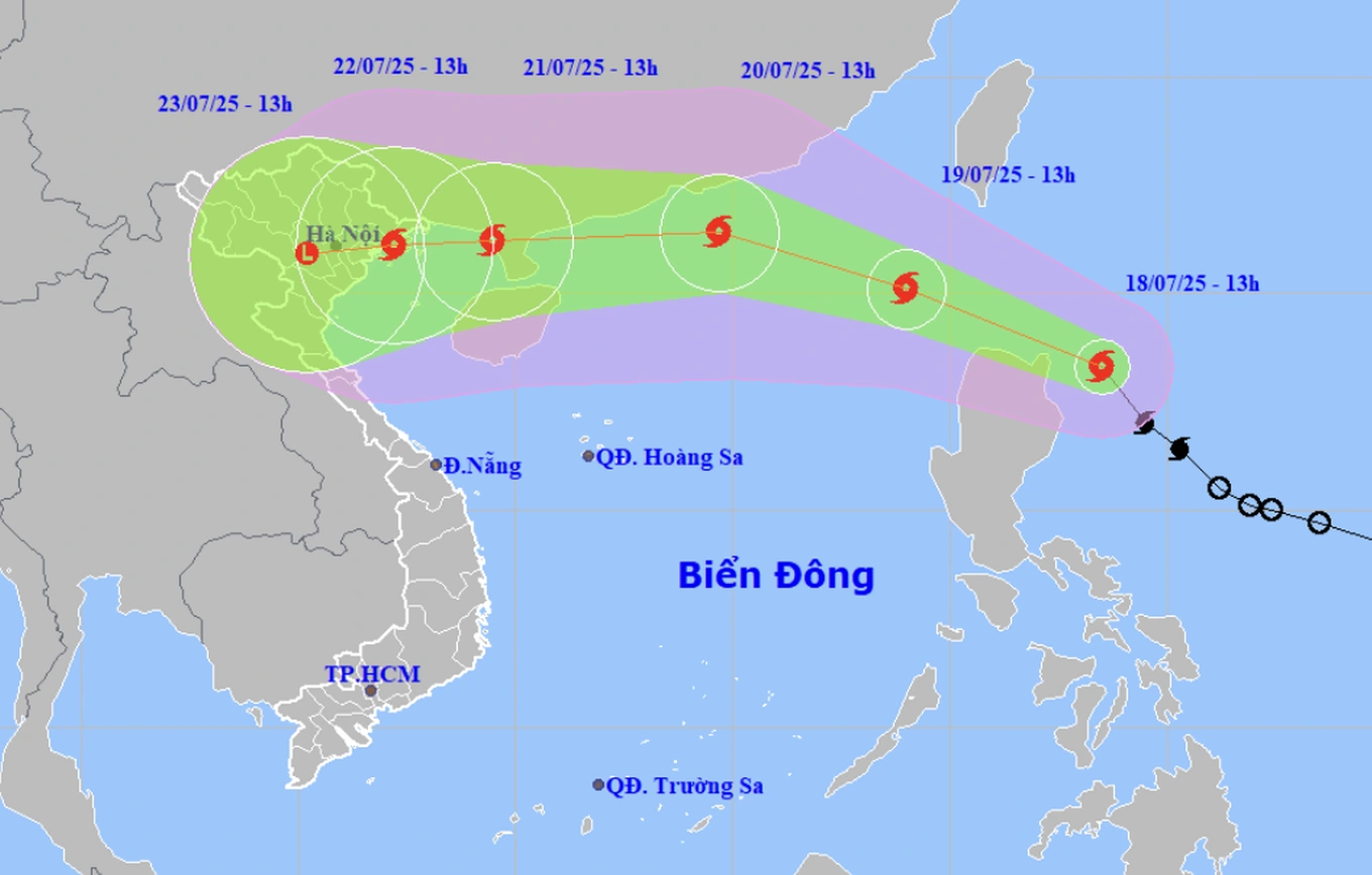
Typhoon Wipha is likely to directly impact mainland Vietnam around July 22 (Photo: NCHMF).
At 1:00 p.m. on July 20, the storm continued to move in a West-Northwest direction, traveling about 20km per hour and was likely to strengthen to level 11-12, gusting to level 14. At this time, the storm was about 490km east of Leizhou Peninsula (China).
The Hydrometeorological Agency said that by 1pm on July 21, Typhoon Wipha was moving west at a speed of 20-25km/h. At this time, the typhoon was operating in the sea west of Leizhou Peninsula (China) with a level 11 intensity, gusting to level 13.
From 72 to 120 hours, the storm will move mainly to the West, traveling 10-15km per hour and gradually weaken.
The Department of Hydrometeorology said that around the evening of July 19, Typhoon Wipha will officially enter the East Sea, becoming the third typhoon of the year. After entering the East Sea, Typhoon Wipha is expected to continue to strengthen to level 11-12 and is likely to directly affect the Vietnamese mainland around July 22.
According to experts, from July 21 to 23, the Northern provinces and Thanh Hoa will have heavy to very heavy rain.
Dantri.com.vn
Source: https://dantri.com.vn/xa-hoi/bao-wipha-kha-nang-cao-se-anh-huong-truc-tiep-den-dat-lien-nuoc-ta-20250718142211199.htm


![[Infographic] In 2025, 47 products will achieve national OCOP](https://vphoto.vietnam.vn/thumb/402x226/vietnam/resource/IMAGE/2025/7/16/5d672398b0744db3ab920e05db8e5b7d)


Comment (0)