
Review the entire system, adjust forecasts to be closer to the people
Starting from July 1, the two-level local government nationwide officially came into operation, which entailed that weather forecasts must be adjusted and updated to suit the new administrative boundary conditions, ensuring accuracy and timeliness in each area, down to each commune, ward, and special zone.
According to comrade Nguyen Thuong Hien, Director of the Department of Hydrometeorology, Ministry of Agriculture and Environment , immediately after the Central Government decided to rearrange administrative units, implementing the direction of the Ministry, the Department of Hydrometeorology conducted a comprehensive review of hydrometeorological and natural disaster forecasting and warning work. In particular, special attention was paid to adjusting bulletins to suit new communes, wards and special zones, helping people and local authorities to quickly access, understand and act promptly.
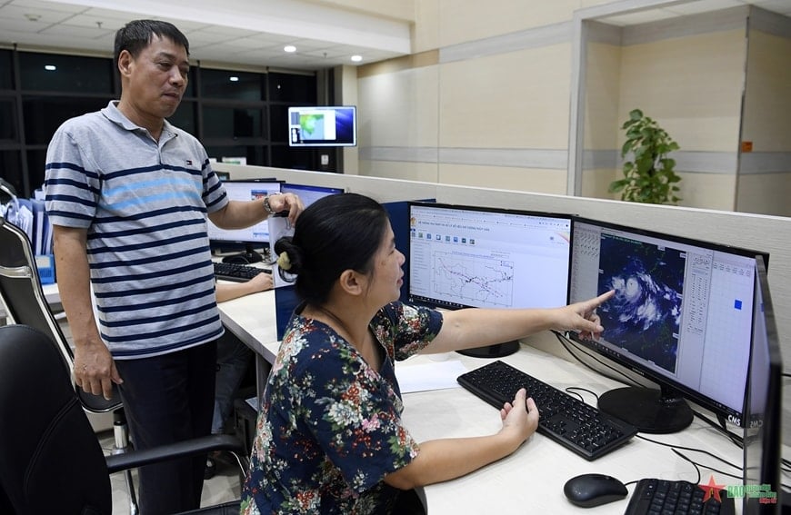 |
Leaders of the Department of Hydrometeorology, Ministry of Agriculture and Environment inspect weather forecasting work. Photo: LA DUY |
This is no small task. Because the previous forecast bulletins were designed to correspond to the old administrative names, from the provincial level to some districts. The merger, separation, and renaming of local units forced the Hydrometeorological Department to update the entire database, meteorological maps, and forecast zoning system.
Previously, the National Center for Hydro-Meteorological Forecasting only provided detailed forecasts for 63 locations, corresponding to 63 provinces and cities. However, the system will now expand and provide detailed updates for all 3,321 communes/wards and new special zones. Each location is linked to 24/7 weather forecast information, with a forecast period of 1 to 10 days in advance.
Not only that, the Center is also building a weather application for mobile phones and computers. Expected to launch in August 2025, the application will provide free, detailed news to the people: From daily weather to natural disaster warnings such as flash floods, landslides, thunderstorms, tornadoes, tropical depressions , heat waves, high tides, etc.
 |
| Associate Professor, Dr. Mai Van Khiem, Director of the National Center for Hydro-Meteorological Forecasting. |
This application will help people, especially in remote areas, to be more proactive in responding to extreme weather. In particular, for local government leaders – who directly direct disaster prevention and control – timely and accurate information to the commune level is a prerequisite for developing appropriate action plans.
Forecast zoning by new administrative place names
The National Center for Hydro-Meteorological Forecasting will forecast for typical climate zones for the whole country, including 7 old zones and adding the Ho Chi Minh City zone.
The areas adjusted according to the new administrative place names include: Northwestern region: Lai Chau, Dien Bien, Son La, Lao Cai, the western area of Phu Tho province (formerly Hoa Binh province).
Northeastern region: Tuyen Quang, Cao Bang, Thai Nguyen, Lang Son, Bac Ninh, Bac Giang, Hai Phong, Hung Yen, Ninh Binh, Hanoi; northern region of Phu Tho province (former Vinh Phuc and Phu Tho provinces).
Thanh Hoa-Hue area; South Central Coast area (Da Nang, Khanh Hoa and coastal areas of Quang Ngai, Gia Lai, Dak Lak, Lam Dong provinces); Central Highlands area: West of Quang Ngai, Gia Lai, Dak Lak, Lam Dong provinces; Southern region; Hanoi area; Ho Chi Minh City area.
 |
| On-duty shift of officers and employees of the National Center for Hydro-Meteorological Forecasting. Photo: LA DUY |
Marine weather forecast bulletin
Northern Gulf of Tonkin area (sea area from Quang Ninh to Ninh Binh); Southern Gulf of Tonkin area (sea area from Thanh Hoa to Northern Quang Tri (the old Quang Binh province sea area); Southern Quang Tri-Quang Ngai sea area (the old Quang Tri-Quang Ngai sea area).
Gia Lai-Khanh Hoa sea area (formerly Binh Dinh-Ninh Thuan sea area); Lam Dong-Ca Mau sea area (formerly Binh Thuan-Ca Mau sea area); Ca Mau-An Giang sea area (formerly Ca Mau-Kien Giang sea area).
The Northern area of the East Sea (the sea area north of 15 degrees North latitude); The Central area of the East Sea (the sea area 10-15 degrees North latitude); The Southern area of the East Sea (the sea area 5-10 degrees North latitude); The Gulf of Thailand area; Hoang Sa Special Zone (the sea area of Hoang Sa archipelago); Truong Sa Special Zone (the sea area of Truong Sa archipelago).
 |
| Staff from the National Center for Hydro-Meteorological Forecasting update weather conditions across the country. Photo: LA DUY |
Associate Professor, Dr. Mai Van Khiem, Director of the National Center for Hydro-Meteorological Forecasting, Department of Hydrometeorology, said that the Center will develop detailed weather forecasts for each location, updated 24/24 hours and forecast up to 10 days in advance. “Previously, we made detailed forecasts for 63 forecast locations (corresponding to 63 provinces and cities before) and now we have renamed the forecast locations according to the commune/ward names in accordance with the new commune/ward administrative units. In addition, the web system will update 10-day weather forecast information at 3,321 new communes/wards. People can access it for free to update the weather situation 24/24 hours,” Associate Professor, Dr. Mai Van Khiem emphasized.
Article and photos: NGUYEN HONG SANG
* Please visit the Society section to see related news and articles.
Source: https://baodaknong.vn/dua-thong-tin-du-bao-thoi-tiet-kip-thoi-den-tan-xa-phuong-dac-khu-257249.html


Comment (0)