
 |
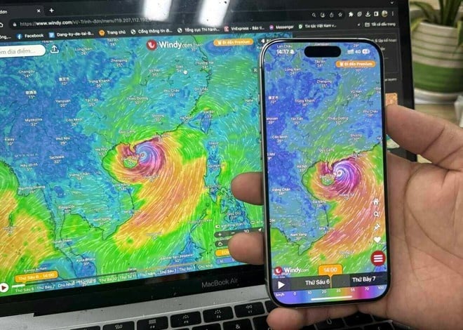
People can monitor the storm's progress on devices. Photo: Anh Quan . |
Natural phenomena are becoming more unpredictable and have a greater impact. In the digital age, tracking storms is no longer entirely dependent on traditional weather reports.
From mobile apps to online satellite maps, a host of modern tools serve the purpose of accessing weather information quickly, intuitively and accurately every hour, every minute. Below are some tools that people can refer to to track the development of storms right on their phones or computers.
Vietnam Disaster Monitoring System (VNDMS)
This system was launched in 2018, operated by the Center for Policy & Technology for Natural Disaster Prevention. The platform integrates multiple data, including hydrometeorology (rain, wind), water level, dike and reservoir cameras, fishing vessel monitoring, landslides, traffic incidents, based on online maps with diverse information layers (wind, rain, salinity, seismic).
VNDMS provides official, multi-dimensional data from monitoring stations, radars, cameras, EVN, and the General Department of Irrigation, ensuring accuracy and diversity. The system is also connected to the Provincial Disaster Monitoring System (PDMS), providing local databases, ready reports, and quick connections to management units for timely direction.
 |
The Disaster Monitoring System reports on the events that followed. Photo: VNDMS. |
The system is equipped with powerful GIS features, meaning you can easily search by administrative area, radius, query incident points on satellite maps/combined street view. However, the interface looks quite specialized, not friendly to most users. In addition, detailed storm simulations are still limited, not displaying dynamic storm paths or replaying international forecasts.
This is still an accurate platform to help people grasp the overall situation, but it needs to combine international tools to visually monitor the storm's path and hourly developments. The system has two versions, web and VNDMS app, available on both Android and iOS.
Windy.com - the leading hurricane tracker
Launched in 2014, Windy.com is a globally renowned online weather map platform developed by a team of Czech programmers. The platform's data is aggregated from leading meteorological models such as ECMWF, GFS, ICON, JMA, and especially supports real-time satellite images.
The tool's strengths lie in its vivid visuals and ease of use. The multi-layered map interface is beautiful, simulating wind, rain, and storms moving in real time. Each element comes with a symbol for users to distinguish. Users can choose to turn on/off the map layer to see all the information or specific items.
 |
The platform provides diverse and detailed weather information. Photo: Windy.com. |
Windy combines many powerful forecasting models (ECMWF, GFS…), updated regularly every 6-12 hours. Therefore, people can still use it for reference purposes, but should still seek information from VNDMS first.
The free version provides most of the important features, users can pay to get premium forecasts. Ordinary people can also easily use Windy thanks to its simple interface, available in Vietnamese, but need to get used to the features to read the map. Windy has a website and a mobile application (Android/iOS).
Accuweather - suitable for all audiences
AccuWeather is one of the world's largest weather forecasting services, headquartered in the US and operating since 1962. Unlike Windy, which specializes in meteorological maps, AccuWeather focuses on detailed local forecasts.
Accuweather’s strength lies in its ability to provide super-detailed hourly, daily, and minute-by-minute forecasts (MinuteCast), which are useful for knowing when the weather is changing. The system also provides warnings for storms, strong winds, lightning, tornadoes, etc. based on its own model and national data.
 |
The main interface provides a variety of information to users. Photo: Accuweather. |
The app's main interface displays current weather conditions, including wind speed, UV index, visibility and pressure, and provides hyper-local forecasts. The app is useful for planning with up to 45-day forecasts.
Accuweather focuses on quick warnings, does not display detailed data layers like Windy, and is not as accurate by region as the National Center for Hydro-Meteorological Forecasting. Therefore, this application is suitable for non-professional users, who only need to quickly see the sunshine/rain forecast and weather for the day.
The platform operates on websites and mobile applications (Android/iOS), supporting many languages including Vietnamese. However, many advanced features are currently in the paid version and the main interface still has many annoying ads.
Source: https://znews.vn/day-la-cach-theo-doi-tung-dien-bien-moi-nhat-cua-bao-wipha-post1570418.html


![[Photo] National Assembly Chairman Tran Thanh Man visits Vietnamese Heroic Mother Ta Thi Tran](https://vphoto.vietnam.vn/thumb/1200x675/vietnam/resource/IMAGE/2025/7/20/765c0bd057dd44ad83ab89fe0255b783)


Comment (0)