

 |
| Deputy Minister of Agriculture and Environment commented on the tropical depression in the East Sea that is likely to strengthen into storm No. 5. |
Strong, fast moving storm, risk of prolonged heavy rain
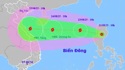
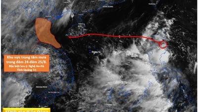
According to the National Center for Hydro-Meteorological Forecasting, the tropical depression in the East Sea is forecast to strengthen into storm No. 5 in the early morning of August 23. This is an especially dangerous storm due to its rapid formation and movement: within just 3 days, from the middle of the East Sea until it directly affects our mainland. It is expected that from August 23 to 24, the storm will impact the Hoang Sa archipelago, and from August 25, it will directly make landfall.
Experts say that storm No. 5 will not weaken before making landfall, but on the contrary, it may strengthen as it approaches the shore due to passing through high-temperature sea areas, accumulating a lot of energy. The forecast intensity is level 10-11, gusting to level 13-14, and even stronger is not excluded.
"The possibility of a downgrade is almost non-existent, because all environmental conditions are favorable for the storm to intensify," emphasized Hoang Duc Cuong, Deputy Director of the National Hydrometeorological Forecasting Department.
In addition to strong winds, heavy rain is also a concern. The storm's circulation is very wide, covering from the North Central region to the North and Central Central regions. The focus of heavy rain is expected from Thanh Hoa to Thua Thien - Hue, with rainfall during the period possibly reaching 600-700mm, lasting for many days from August 23 to August 27. If the storm deviates from its direction, the area of influence may expand to the north (Hanoi, Hung Yen, Hai Duong, Hai Phong) or reach Quang Nam , Quang Ngai, Da Nang.
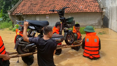
Deputy Minister Nguyen Hoang Hiep expressed concern that since the beginning of the year, our country has suffered three storms, of which storm No. 3 caused heavy rain in Nghe An and Thanh Hoa, leaving much damage; storm No. 4 had little impact. Storm No. 5 is forecast to have a direct and stronger impact. The most worrying thing is the unusual and unpredictable rainfall. In fact, the recent rain at Ban Ve hydropower reservoir has far exceeded all historical scenarios.
“If this scenario repeats itself, the situation will be extremely complicated. Storms usually only last about three days after making landfall, but rains in the Lao basin can continue for another three to four days, causing water to rush to Vietnam later. Therefore, we cannot be complacent and think that once the rain in the country has stopped, we can rest assured,” said Deputy Minister Nguyen Hoang Hiep.
Proactive response plan, no surprises
Faced with these risks, Deputy Minister Nguyen Hoang Hiep requested the National Hydrometeorological Department to direct the Forecasting Center and local forecasting units in the North Central and Central coastal regions to improve warning capacity and provide the earliest and most accurate information to the authorities.
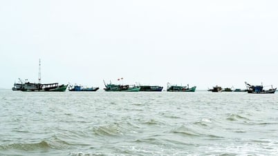
"Even a 30-minute to 1-hour warning must be timely to stop activities at sea, bring ships to safe shelters, and avoid repeating the unfortunate incident in Quang Ninh recently," the Deputy Minister emphasized.
Along with that, the Deputy Minister also assigned the Department of Dykes and Natural Disaster Prevention and Control to immediately draft a detailed instruction document to send to localities; the National Hydrometeorological Department advised the leaders of the Ministry of Agriculture and Environment to send a document to the Ministry of Industry and Trade to coordinate in reviewing the entire system of hydroelectric and irrigation reservoirs in the affected area, ensuring absolute safety while still maintaining capacity to cut floods.
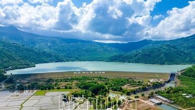
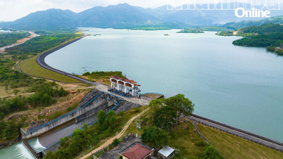
The North Central region currently has about 2,300 reservoirs, of which the storage capacity is reaching 71% to 82%. Large reservoirs such as Cua Dat (Thanh Hoa) reach 88%, Ke Go (Ha Tinh) 47%, Ta Trach (Thua Thien - Hue) 52%. Some reservoirs such as Ngan Truoi are still low, but most of the reservoirs are full at the end of the rainy season. 51 reservoirs with gate valves in the region have been inspected for operation, basically ensuring safety.
However, Deputy Minister Nguyen Hoang Hiep is particularly concerned about the dense system of small lakes and cascade hydropower plants in the central region: “If not operated properly, small lakes will discharge water at the same time, creating a very dangerous chain effect. This is the biggest challenge when responding to storms, and needs to be closely monitored from now on.”
Regarding response solutions, Deputy Minister Nguyen Hoang Hiep emphasized some urgent requirements:
First, proactively evacuate mountainous residents. Localities must develop clear scenarios, identify rainfall thresholds and signs of landslides to evacuate people in a timely manner. Practical lessons show that many village chiefs who flexibly decided to evacuate early have saved people's lives. "The principle is to avoid casualties due to landslides at all costs," said the Deputy Minister.
Second, ensure the safety of reservoirs. The Ministry of Industry and Trade coordinates with the Ministry of Agriculture and Environment to urgently review all hydroelectric and irrigation reservoirs in the North Central region on August 22. Large reservoirs are basically guaranteed to cut floods, but small reservoirs managed by localities must be inspected and tested to avoid incidents.
Third, stock up on food and necessities. Villages at risk of being cut off need to prepare food, water, and essential supplies in advance. “We cannot wait until the flood comes to distribute bags of rice and boxes of instant noodles to help the hungry, the consequences will be very serious,” the Deputy Minister noted.
Fourth, ensure production safety. The Department of Dykes and Natural Disaster Prevention and Control must request a review of agricultural, livestock and aquaculture production in key areas. If necessary, early harvests must be recommended, in the spirit of “green at home is better than old in the field”.
Fifth, strictly manage tourism and boating activities. The Deputy Minister warned of the risk of thunderstorms before the storm, especially during the weekend and the September 2 holiday. “We have the ability to forecast 30-60 minutes in advance, we need to arrange staff on duty, update continuously to warn in time, not to let the unfortunate incident like in Quang Ninh happen again”. Thanh Hoa, Nghe An, Quang Ninh provinces - where many tourists gather - must soon issue warnings and temporarily stop dangerous activities at sea.
In addition, the Deputy Minister also noted the preparations for the 80th anniversary of National Day September 2.
“Many localities are setting up stages, billboards, and slogans. A storm can blow everything away, which is both dangerous and wasteful. Careful consideration is needed and events should only be held when absolute safety is guaranteed,” the Deputy Minister reminded.
Deputy Minister Nguyen Hoang Hiep especially emphasized: “We absolutely must not be passive or surprised. All plans must be prepared early, specifically, closely following reality and implemented from today.”
On the afternoon of August 22, the Ministry of Agriculture and Environment will issue a detailed advisory document to localities, report to the Government and propose to hold an online meeting with key provinces on August 23. After that, depending on the situation, working groups will be established to go directly to key areas. |
People's Newspaper
Source: https://baodongnai.com.vn/kinh-te/moi-truong/202508/chu-dong-ung-pho-voi-ap-thap-nhiet-doi-co-the-manh-len-thanh-bao-so-5-khong-de-bi-dong-bat-ngo-81c0fb7/
![[Photo] President Luong Cuong receives delegation of the Youth Committee of the Liberal Democratic Party of Japan](https://vphoto.vietnam.vn/thumb/1200x675/vietnam/resource/IMAGE/2025/8/22/2632d7f5cf4f4a8e90ce5f5e1989194a)
![[Photo] President Luong Cuong attends special political-artistic television show "Golden Opportunity"](https://vphoto.vietnam.vn/thumb/1200x675/vietnam/resource/IMAGE/2025/8/22/44ca13c28fa7476796f9aa3618ff74c4)


![[Photo] Prime Minister Pham Minh Chinh chairs the conference to review the 2024-2025 school year and deploy tasks for the 2025-2026 school year.](https://vphoto.vietnam.vn/thumb/1200x675/vietnam/resource/IMAGE/2025/8/22/2ca5ed79ce6a46a1ac7706a42cefafae)


Comment (0)