

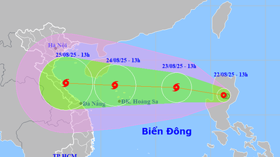
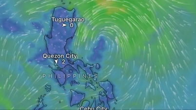
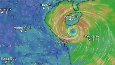
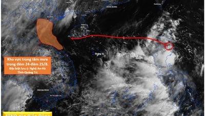
Today and tomorrow, the low pressure area will move west-northwest at a speed of 15-20km per hour, entering the East Sea and is likely to strengthen into a tropical depression.
After forming, the tropical depression is likely to continue to strengthen into a storm with a probability of 60-70%. The storm will move quickly towards the Gulf of Tonkin.
Due to the influence of the low pressure circulation, then the tropical depression that is likely to strengthen into a storm, in the coming days, the northern and central areas of the East Sea (including the Hoang Sa special zone) and the Gulf of Tonkin will have increasingly stronger winds and bad weather.

Ships operating in these sea areas need to take proactive precautions to ensure safety.
In addition, from August 25, in the North and the area from Thanh Hoa to Hue, there is a possibility of widespread moderate to heavy rain.
The meteorological agency said that weather developments could be complicated, and suggested that people and localities regularly monitor and update information through official bulletins of the hydrometeorological agency.
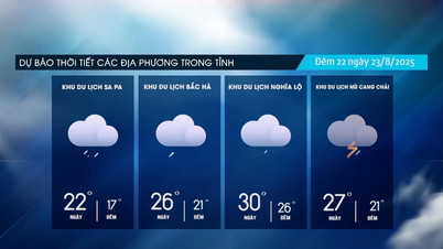
Meanwhile, the mountainous areas of the North continue to have rain, moderate rain and scattered thunderstorms, locally heavy to very heavy rain; the areas from Gia Lai to Lam Dong have showers and scattered thunderstorms, locally heavy rain; the Southern areas have rain, moderate rain and thunderstorms, locally heavy to very heavy rain.
Today, August 22, the mountainous areas of the North will have moderate rain, heavy rain and thunderstorms with common rainfall of 40-100mm, locally very heavy rain over 250mm. From August 23, heavy rain in the mountainous areas of the North will gradually decrease.
Source: https://baolaocai.vn/bien-dong-co-the-don-bao-trong-vai-ngay-toi-post880221.html


![[Photo] President Luong Cuong receives delegation of the Youth Committee of the Liberal Democratic Party of Japan](https://vphoto.vietnam.vn/thumb/1200x675/vietnam/resource/IMAGE/2025/8/22/2632d7f5cf4f4a8e90ce5f5e1989194a)
![[Photo] Prime Minister Pham Minh Chinh chairs the conference to review the 2024-2025 school year and deploy tasks for the 2025-2026 school year.](https://vphoto.vietnam.vn/thumb/1200x675/vietnam/resource/IMAGE/2025/8/22/2ca5ed79ce6a46a1ac7706a42cefafae)


Comment (0)