

.jpg)
Water level at 7:00 a.m. on August 27, 2025 at Pha Lai, Cat Khe, Ben Binh was below alert level 1.
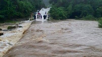
From the evening of August 27 to August 29, 2025, on Thai Binh River and Kinh Thay River, there is a possibility of a flood with a flood amplitude of 1.5 - 3 m.
On Thai Binh River at Pha Lai and Cat Khe stations, it is likely to be above alert level 1. On Kinh Thay River at Ben Binh station, it is likely to be at alert level 1 - alert level 2.
High river floods are likely to cause flooding in low-lying areas, mid-river flats, and riverside areas with a flooding depth of 0.1 - 0.5m, with some areas being deeper, and the flooding may last 2 - 3 days. It is necessary to guard against the risk of landslides and erosion of riverbanks.
On August 27, Hai Phong city area was still affected by local heavy rain combined with floods on high rivers, reducing drainage capacity, high risk of flooding in some urban areas, many inner city streets of Hai Phong, with flooding depth from 0.2 - 0.4m, some places over 0.5m; flooding duration from 1 hour to 3 hours, some places longer. It is necessary to guard against landslides in mountainous areas, riverside areas and flooding in low-lying areas.
.png)
Floods combined with heavy rains can cause flooding in low-lying areas along rivers, affecting people's lives, traffic activities, aquaculture on rivers and agricultural production along rivers.
Landslide warning
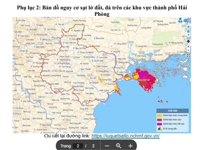
In the past 24 hours, due to prolonged heavy rain, soil moisture models show that some areas of Hai Phong city are nearly saturated (over 90%) or have reached saturation.
In the next few hours, there is a risk of landslides on the mountain slopes of Lai Xuan commune, Phu Lien ward (Thien Van hill), Cat Hai special zone (Hien Hao, Xuan Dam, Phu Long, Cat Ba, Viet Hai areas) and Do Son ward (Van Huong, Hai Son), Nam Do Son ward (Ngoc Xuyen).
Source: https://baohaiphong.vn/canh-bao-lu-tren-cac-song-o-hai-phong-519238.html
![[Photo] National Assembly Chairman Tran Thanh Man holds talks with New Zealand Parliament Chairman](https://vphoto.vietnam.vn/thumb/1200x675/vietnam/resource/IMAGE/2025/8/28/c90fcbe09a1d4a028b7623ae366b741d)
![[Photo] Images of the State-level preliminary rehearsal of the military parade at Ba Dinh Square](https://vphoto.vietnam.vn/thumb/1200x675/vietnam/resource/IMAGE/2025/8/27/807e4479c81f408ca16b916ba381b667)


Comment (0)