
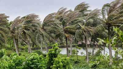
According to the National Center for Hydro-Meteorological Forecasting, the area near the storm's eye has strong winds of level 9-10 (speed over 100km/h), gusts of level 13, accompanied by widespread heavy rain.

In Co To Special Zone, from the night of July 21 to the early morning of July 22, heavy rain and strong winds caused widespread power outages in the area, making it difficult to respond, especially at evacuation points, shelters and rescue units on the island.
However, the authorities quickly deployed backup generators at key facilities such as medical stations, People's Committee headquarters, evacuation points... At the same time, they increased their on-call response, promptly handled arising situations, and ensured people's safety.


At 7am this morning, Secretary of the Party Committee of Co To Special Zone Le Ngoc Han confirmed: “Co To is safe during storm No. 3”. She said that since dawn, the local government system has continuously reported briefly on “safe areas”.
“It was very touching when, along with the information pouring in, we received the image of the national flag flying at the sovereignty flagpole on Thanh Lan Island - an island isolated from the large Co To Island with nearly 2,000 people living there. We would like to thank everyone for their affection for the sea and islands, for their timely attention and encouragement to Co To so that the cadres, soldiers and people on the island can successfully weather the storm! Currently, the villages and islands are all safe for the people, and no significant damage has been recorded in the entire special zone,” the Co To Secretary expressed.

In Van Don Special Economic Zone, the rain and wind began to ease early in the morning. As of 7am, no casualties have been reported. Some trees and billboards were broken in residential areas and on main roads. Local authorities have directed forces to urgently inspect, count and handle any incidents if any.

In central areas of Quang Ninh such as Ha Long, Hong Gai, Bai Chay..., moderate rain and winds of level 5-6, gusting to level 7, continued this morning. Some trees and signs were knocked down due to strong winds, but people were safe.

To ensure the safety of people and vehicles, since the evening of July 21, authorities have banned motorbikes and non-motorized vehicles from traveling across Bai Chay Bridge due to wind gusts of level 7-8. By 7:45 this morning, when the wind had subsided, the barriers were removed and vehicles were allowed to travel again. However, authorities still advise people to pay attention to safety, keep distance and speed when traveling across the bridge.
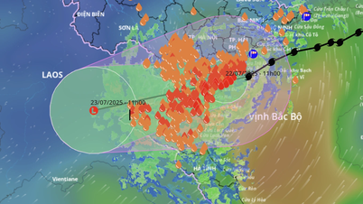
* At 8:30 a.m., Hanoi began to have howling winds. Meteorological experts reported that at 7:50 a.m. on July 22, storm No. 3 had weakened while still in the Hai Phong - Ninh Binh sea area and was moving south.
According to Mr. Hoang Phuc Lam, Deputy Director of the National Center for Hydro-Meteorological Forecasting, at 7:00 a.m. on July 22, the storm's center was located in the coastal waters of Hai Phong - Ninh Binh.
The storm is still at level 9, gusting to level 12, moving slowly at a speed of about 15km/hour.

It is forecast that this afternoon, the storm's eye will make landfall in the Hung Yen - Ninh Binh area and then continue to weaken into a tropical depression, affecting the mainland from Hai Phong to Thanh Hoa.
 predicts that storm No. 3 (Wipha) will make landfall at noon to afternoon on July 22.")
As of the morning of July 22, due to the influence of the storm shifting south and moving from the Gulf of Tonkin inland in a West-Southwest direction, the risk of flash floods and landslides is increasing rapidly in many localities, especially the mountainous areas of Thanh Hoa and Nghe An during the day and night of July 22.

Mr. Nguyen Huu Huynh, an expert from the National Center for Hydro-Meteorological Forecasting, warned: in the past 12 hours, the provinces of Phu Tho, Thanh Hoa and Nghe An have had moderate to very heavy rain.
Some locations recorded heavy rainfall such as Van Mai (Phu Tho) with 115mm, Thach Quang (Thanh Hoa) 95mm, Muong Long (Nghe An) 69mm. Soil moisture models show that many areas in these 3 provinces have reached a state of near saturation or complete saturation, with humidity above 85%.

In the next 3 to 6 hours, this area will continue to have rain, in some places exceeding 100mm, accompanied by the risk of landslides, flooding, and flash floods.


The Department of Meteorology and Hydrology continuously issues bulletins warning of the risk of floods and landslides in the storm's landing area. It is forecasted that from July 22 to 23, the Northern Delta, Thanh Hoa and Nghe An will have heavy to very heavy rain with thunderstorms, with rainfall ranging from 100-200mm, with some places exceeding 300mm.
Other areas in the North and Ha Tinh have moderate to heavy rain, some places have very heavy rain, with total rainfall of 50-100mm, locally exceeding 150mm.
Source: https://www.sggp.org.vn/bao-so-3-do-bo-vao-dat-lien-quang-ninh-mua-lon-gio-giat-nhung-nguoi-dan-an-toan-post804821.html


Comment (0)