

Pine forest area, Hung Thang commune, Hai Phong , wind level 5-6 at 9:50 a.m. on July 22, 2025 - Photo: TIEN NGUYEN
Chief of the Party Central Committee Office Le Hoai Trung signed the Secretariat's directive on responding to storm No. 3 (Wipha).
Official dispatch to provincial, municipal and central party committees; central party committees; party committees of ministries, branches and socio- political organizations at the central level; party committees of central public service units; and members of the central party committee.
Accordingly, at the meeting on July 22, before the complicated developments of storm No. 3 (storm Wipha), implementing the opinion of General Secretary To Lam , the Secretariat directed a number of important contents.
This is a very strong storm, moving quickly, with a very wide and dangerous range and intensity of influence on sea and land...
From July 22, coastal areas from Quang Ninh to Thanh Hoa will be directly affected by the storm, causing strong winds and heavy rain in the Northern provinces and North Central provinces (Thanh Hoa, Nghe An, Ha Tinh).
To proactively respond to storms and heavy rains, the risk of flash floods, landslides, and inundation, and ensure the safety of people's lives and property and state assets, the Secretariat requests Party committees at all levels, Party organizations, authorities, the Vietnam Fatherland Front, and socio-political organizations not to be subjective, to strengthen direction, supervision, inspection, and response to storm No. 3 (storm Wipha), and to minimize damage.
Daily update the situation and send reports to the Central Party Office (before 4:00 p.m. daily).
The Secretariat assigned the Party Central Office to preside over and coordinate with relevant agencies to monitor and synthesize the situation, and daily report to the Politburo and the Secretariat on related situations.
Storm No. 3 gradually weakens, circulation causes heavy rain in many places
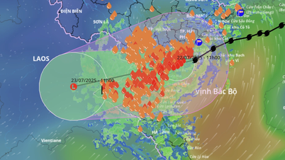
At 11am today (July 22), the storm's eye was on the mainland of Hung Yen - Ninh Binh provinces. The strongest wind near the storm's eye was level 8, gusting to level 10; moving in a West Southwest direction.
The National Center for Hydro-Meteorological Forecasting said that in the afternoon and evening of July 22, storm No. 3 is forecast to continue moving southwest and gradually weaken into a tropical depression and then a low pressure area.
Storm No. 3 continues to cause heavy rain in Nghe An and Thanh Hoa with average rainfall of 50-100mm, while southern Son La and southern Phu Tho have rain of 30-70mm.
With such continued rainfall, there is a high risk of flash floods, landslides, and localized flooding this afternoon and tonight, especially in the west of Thanh Hoa and Nghe An.
Currently in Nghe An and Thanh Hoa there is heavy rain, rivers and streams are starting to form flood flows and will increase sharply.
Therefore, the Center recommends that during this time, people limit their movement. If necessary, they should avoid going near rivers and streams and through spillways because floods can come quickly and it may be too late to respond.
In addition, because the storm clouds are mainly concentrated in the southwestern circulation of the storm, the provinces/cities in the northern circulation of storm No. 3, including Hanoi and the northeastern provinces/cities, will have less rainfall compared to last afternoon and night.
Tuoitre.vn
Source: https://tuoitre.vn/ban-bi-thu-chi-dao-kiem-tra-ung-pho-bao-so-3-han-che-thap-nhat-muc-thiet-hai-20250722135604936.htm


Comment (0)