
According to the news of Khanh Hoa Province Hydrometeorological Station, at 10:00 am on July 5, storm No. 2 was in the northeastern sea area of the northern East Sea. Winds near the storm center were at level 9 (75 - 88 km/h), gusting to level 11. The storm slowly moved northward at a speed of about 5 km/h and was likely to strengthen further.
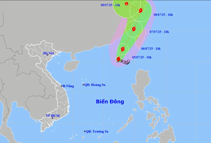 |
| Location and forecast direction of storm number 2. |
Forecast until 10:00 on July 6, storm No. 2 in the northeastern sea of the East Sea, wind near the storm center is strong level 10-11, gust level 13.
Due to the storm's influence, the northeastern sea area of the northern East Sea will experience stormy rain, strong winds of level 7-8, near the storm's center level 9-11, gusting to level 13; rough seas, waves 4-6m high. Ships operating in the danger zone are at high risk of being affected by thunderstorms, tornadoes, strong winds and big waves.
According to the news of the specialized agency, on the morning of July 5, the sea area of Truong Sa special zone will have showers and thunderstorms in some places; strong southwest winds of level 4-5. It is forecasted that on the day and night of July 5, the sea area of Khanh Hoa and Truong Sa special zone will have strong southwest winds of level 5, sometimes level 6, gusting to level 7, rough seas. In addition, the sea area north of Truong Sa special zone will have showers and thunderstorms in some places. During the thunderstorms, there is a possibility of tornadoes and strong gusts. All ships and other activities in the above sea areas are at high risk of being affected by strong winds. On the day and night of July 6, the sea area of Khanh Hoa including Truong Sa special zone will have strong southwest winds of level 5, sometimes level 6, gusting to level 7.
HD
Source: https://baokhanhhoa.vn/xa-hoi/202507/bao-so-2-giat-cap-11-kha-nang-manh-them-98b10d8/


![[Photo] Prime Minister Pham Minh Chinh receives leaders of several leading Brazilian corporations](https://vphoto.vietnam.vn/thumb/1200x675/vietnam/resource/IMAGE/2025/7/6/3622160b379746e6bca82f804ea35e47)


![[OCOP REVIEW] Bay Quyen sticky rice cake: A hometown specialty that has reached new heights thanks to its brand reputation](https://vphoto.vietnam.vn/thumb/402x226/vietnam/resource/IMAGE/2025/7/3/1a7e35c028bf46199ee1ec6b3ba0069e)


Comment (0)