
According to the National Center for Hydro-Meteorological Forecasting, due to the influence of storm No. 1's circulation, Bach Long Vi Island (Hai Phong) has strong winds of level 7, gusting to level 10; Dam Ha (Quang Ninh) has strong winds of level 6, gusting to level 7; Cua Ong and Mong Cai (Quang Ninh), Phu Lien ( Hai Phong ) have strong gusts of level 6; Co To (Quang Ninh) has strong gusts of level 7.
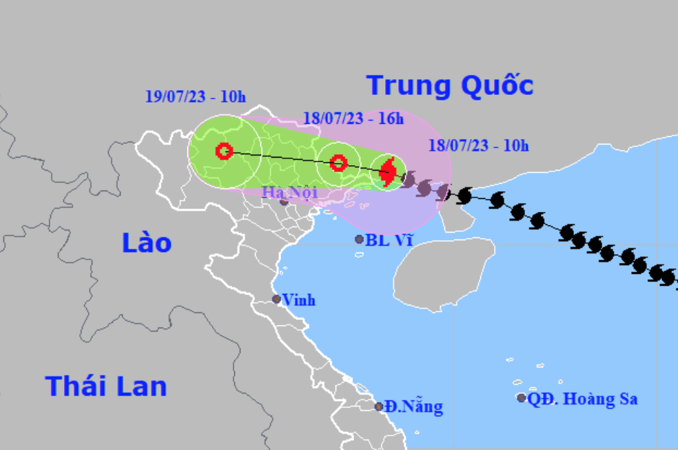
At 10:00 a.m. today (July 18), the center of the storm was at about 21.8 degrees North latitude; 108.4 degrees East longitude, on the mainland in the southern region of Guangxi Province (China), about 60km East Northeast of Mong Cai (Quang Ninh). The strongest wind near the center of the storm was level 9 (75-88km/h), gusting to level 11.
It is forecasted that by 4:00 p.m. the same day, the storm will move in a West-Northwest direction, at a speed of about 20 km/h and gradually weaken; located on the Vietnam-China border area; the strongest wind is level 6, gusting to level 8.
At 10:00 a.m. on July 19, the storm moved in the West Northwest direction, at a speed of 20-25 km/h, continued to weaken and gradually dissipated; located on the mainland of the Northwestern provinces.
Affected by the storm, the northern area of Bac Bo Gulf (including Bach Long Vy and Co To island districts) has strong winds of level 6-7, near the storm center level 8, gusting to level 10. Rough seas.
Coastal areas of Quang Ninh and Hai Phong provinces have strong winds of level 6-7, gusting to level 9; Lang Son and Bac Giang provinces have gusts of level 6-7.
The Gulf of Tonkin has waves 2-3.5m high. The coastal areas of Quang Ninh-Hai Phong have waves 1.5-2.5m high.
Coastal areas of Quang Ninh-Hai Phong provinces are experiencing storm surges of 0.2-0.4m. Low-lying coastal areas and river mouths of Quang Ninh-Hai Phong are at risk of flooding due to the combined impact of high tides, big waves and storm surges this afternoon.
Today and tomorrow, in the Northeast and Viet Bac, there will be heavy to very heavy rain with common rainfall of 100-200mm, locally over 300mm; in the Northwest, there will be heavy rain with rainfall of 50-150mm, in the Northern Delta and Thanh Hoa, there will be moderate rain, heavy rain with common rainfall of 50-100mm.
Beware of heavy rain causing urban flooding. Warning of high risk of flash floods and landslides in the provinces of Quang Ninh, Lang Son, Cao Bang, Ha Giang, Lao Cai, Yen Bai .
Beware of the risk of thunderstorms, tornadoes and strong gusts of wind in the storm circulation area, both before and during the storm's landfall.
Source


![[Photo] Signing of cooperation between ministries, branches and localities of Vietnam and Senegal](https://vphoto.vietnam.vn/thumb/1200x675/vietnam/resource/IMAGE/2025/7/24/6147c654b0ae4f2793188e982e272651)


Comment (0)