
At noon on June 11, a representative of the provincial Hydrometeorological Station said that if it continues to move in the forecast direction, storm No. 1 will likely only cause rain at sea and inland areas of coastal provinces and cities, especially in the Central region.
For Hai Duong , storm No. 1 is forecast to only cause widespread heat, with a very low chance of rain.
The cause is that the wind field on the western edge of the storm's circulation is strong, sucking all the moisture from the mainland, causing hot and dry weather.

The provincial Hydrometeorological Station forecasts that on June 14 and 15, areas in Hai Duong will experience heat waves with the highest temperature ranging from 35 - 37 degrees Celsius, and heat waves are likely to appear from June 13.
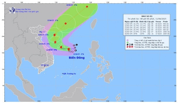
According to the National Center for Hydro-Meteorological Forecasting, storm No. 1 is still moving slowly in a west-northwest direction at a speed of about 5 - 10 km/hour.
Forecast at around 7am on June 12, the storm's eye is located in the Hoang Sa sea area, moving west-northwest at a speed of about 10km/h and is likely to strengthen.
At 7:00 a.m. on June 13, the center of the storm was at about 18.2 degrees north latitude and 109.8 degrees east longitude in the southern area of Hainan Island (China).
TMSource: https://baohaiduong.vn/bao-so-1-rat-it-co-kha-nang-gay-mua-cho-khu-vuc-hai-duong-413785.html


Comment (0)