
 |
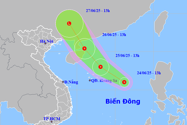
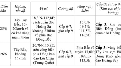
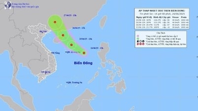
| Location and forecast direction of tropical depression in the East Sea. |
The tropical depression will cause thunderstorms and strong winds of level 6-7, gusting to level 9, and rough seas in the northern East Sea (including the Hoang Sa archipelago); waves of 2-4m high. Ships operating in the above areas should be aware of the high risk of tornadoes, strong gusts, and large waves.
Also according to the news of Khanh Hoa Province Hydrometeorological Station, on the morning of June 24, through monitoring on weather radar images and satellite images, it was shown that convective clouds developed in Cam Lam and Khanh Son areas. It is forecasted that in the afternoon of June 24, convective clouds will continue to develop, causing showers and thunderstorms in the above areas, which may then spread to other areas such as Khanh Vinh, Dien Khanh, and Cam Ranh. During thunderstorms, be on guard against lightning, tornadoes, hail and strong gusts of wind; agencies, departments, branches and people should pay attention to prevention and ensure safety.
H.D
Source: https://baokhanhhoa.vn/xa-hoi/202506/ap-thap-nhiet-doi-tren-bien-dong-canh-bao-giong-loc-tren-dat-lien-tinh-khanh-hoa-d13148b/


![[Photo] General Secretary To Lam meets with the Group of Young National Assembly Deputies](https://vphoto.vietnam.vn/thumb/1200x675/vietnam/resource/IMAGE/2025/6/24/618b5c3b8c92431686f2217f61dbf4f6)

![[Photo] The 9th Party Congress of the National Political Publishing House Truth](https://vphoto.vietnam.vn/thumb/1200x675/vietnam/resource/IMAGE/2025/6/24/ade0561f18954dd1a6a491bdadfa84f1)
![[Photo] Close-up of modernized Thu Thiem, connecting new life with District 1](https://vphoto.vietnam.vn/thumb/1200x675/vietnam/resource/IMAGE/2025/6/24/d360fb27c6924b0087bf4f288c24b2f2)


Comment (0)