
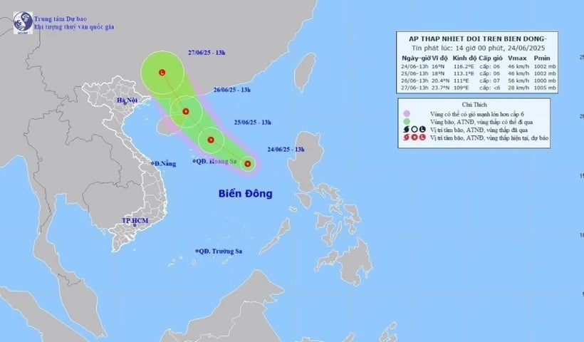
Direction of movement of the tropical depression on the afternoon of June 24. (Photo: VNA)
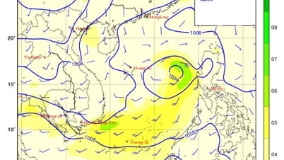
According to the National Center for Hydro-Meteorological Forecasting, the tropical depression is about 470km east of the Hoang Sa area. The strongest wind is level 6, gusting to level 8. The tropical depression is moving northwest at a speed of about 15km/h.
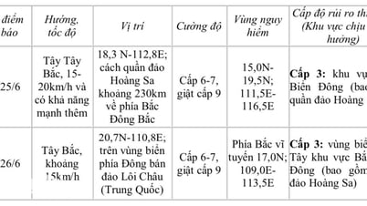
Commenting on the development of the tropical depression, Associate Professor, Doctor, Director of the National Center for Hydro-Meteorological Forecasting Mai Van Khiem said that as of 7 p.m. on June 25, the tropical depression was about 230km northeast of the Hoang Sa area and moving northwest. The strongest wind was level 6-7, gusting to level 9.
As of 7 p.m. on June 26, the tropical depression was located in the sea east of Leizhou Peninsula (China) and continued to move northwest. The strongest wind was level 6-7, gusting to level 9.
From the next 48 to 72 hours, the tropical depression will move northwest at a speed of 15-20km/h, gradually weakening in intensity. Due to the impact of the tropical depression, the North East Sea area (including Hoang Sa area) will have thunderstorms, strong winds of level 6-7, gusts of level 9, rough seas, and waves 2-4m high.
Ships operating in the above mentioned dangerous areas are likely to be affected by storms, whirlwinds, strong winds and large waves.
Along with that, the National Center for Hydro-Meteorological Forecasting informed that from 20:40 on June 24 to 1:40 on June 25, the areas of Cao Bang , Lai Chau, Quang Nam, Quang Ngai, Kon Tum and Lam Dong provinces continued to have rain with common accumulated rainfall such as Cao Bang, Lai Chau, Kon Tum and Lam Dong provinces had rain from 10-35mm, some places over 70mm; Quang Nam and Quang Ngai provinces had rain from 20-40mm, some places over 90mm.
There is a risk of flash floods on small rivers and streams, landslides on steep slopes in the above provinces, especially in the districts of Muong Te, Tan Uyen, Than Uyen (Lai Chau province); Bao Lac, Bao Lam, Ha Quang, Nguyen Binh, Quang Hoa, Trung Khanh (Cao Bang province); Bac Tra My, Dai Loc, Dong Giang, Hiep Duc, Nam Giang, Nam Tra My, Phuoc Son, Que Son, Tay Giang, Tien Phuoc (Quang Nam province); Ba To, Minh Long, Son Ha, Son Tay, Tra Bong (Quang Ngai province); Dak Ha, Kon Plong, Kon Ray, Sa Thay ( Kon Tum province); Da Huoai, Dam Rong, Di Linh (Lam Dong province).
Warning level of natural disaster risk due to flash floods, landslides, land subsidence due to heavy rain or level 1 flow.
Flash floods and landslides can have very negative impacts on the environment, threaten people's lives; cause local traffic congestion, affect the movement of vehicles; destroy civil and economic works, causing damage to production and socio-economic activities.
The Hydrometeorological Agency recommends that local authorities pay attention to reviewing bottlenecks and vulnerable locations in the area to take preventive and response measures.
From 5:00 p.m. to 7:00 p.m. on June 24, Lai Chau province had moderate to heavy rain such as Ta Tong 43.8mm (Lai Chau)...
From 3:00 p.m. to 5:00 p.m. on June 24, the provinces of Cao Bang, Quang Nam, Quang Ngai, Kon Tum and Lam Dong had moderate to heavy rain, and some places had very heavy rain such as: Phuoc Cat-Cat Tien (Lam Dong) 137.6mm; Can Yen (Cao Bang) 69mm; Mang Canh (Kon Tum) 55.4mm; Phuoc Hiep (Quang Nam) 44.4mm... The soil moisture model shows that some areas in the above provinces are nearly saturated (over 85%) or have reached a saturated state.
Source: https://baobinhphuoc.com.vn/news/9/174402/ap-thap-nhiet-doi-di-chuyen-theo-huong-tay-bac-voi-suc-gio-cap-6-giat-cap-8

![[Photo] General Secretary To Lam meets with the Group of Young National Assembly Deputies](https://vphoto.vietnam.vn/thumb/1200x675/vietnam/resource/IMAGE/2025/6/24/618b5c3b8c92431686f2217f61dbf4f6)
![[Photo] Close-up of modernized Thu Thiem, connecting new life with District 1](https://vphoto.vietnam.vn/thumb/1200x675/vietnam/resource/IMAGE/2025/6/24/d360fb27c6924b0087bf4f288c24b2f2)


![[Photo] The 9th Party Congress of the National Political Publishing House Truth](https://vphoto.vietnam.vn/thumb/1200x675/vietnam/resource/IMAGE/2025/6/24/ade0561f18954dd1a6a491bdadfa84f1)


Comment (0)