

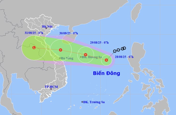
According to the National Center for Hydro-Meteorological Forecasting, this morning (August 28), the center of the tropical depression is over the eastern sea of the North East Sea. The strongest wind near the center of the tropical depression is level 6-7 (39-61km/h), gusting to level 9 and is moving southwest.
It is forecasted that by 7am tomorrow morning (August 29), the center of the tropical depression will be over the Hoang Sa special zone sea area, with a current intensity of level 7, gusting to level 9. In the next 24 to 48 hours, the tropical depression will continue to move west-northwest at a speed of about 20km/h, with little chance of changing its intensity.
At 7:00 a.m. on August 30, the center of the tropical depression was in the sea area of Nghe An to Da Nang, maintaining a strong intensity of level 7, gusting to level 9.
From the next 48 to 72 hours, the tropical depression will continue to move mainly in a westerly direction and is likely to make landfall in the central provinces and gradually weaken.
According to Mr. Mai Van Khiem, Director of the National Center for Hydro-Meteorological Forecasting, around August 30 to 31, the tropical depression will directly affect the North Central provinces ( Thanh Hoa to Hue). From August 30 to September 1, in the North and the Thanh Hoa - Hue area, there will be moderate to heavy rain.
Source: https://quangngaitv.vn/ap-thap-nhiet-doi-kha-nang-anh-huong-mien-trung-6506624.html
![[Photo] Politburo works with the Standing Committee of Cao Bang Provincial Party Committee and Hue City Party Committee](https://vphoto.vietnam.vn/thumb/1200x675/vietnam/resource/IMAGE/2025/8/28/fee8a847b1ff45188749eb0299c512b2)
![[Photo] National Assembly Chairman Tran Thanh Man holds talks with New Zealand Parliament Chairman](https://vphoto.vietnam.vn/thumb/1200x675/vietnam/resource/IMAGE/2025/8/28/c90fcbe09a1d4a028b7623ae366b741d)
![[Photo] General Secretary To Lam attends the opening ceremony of the National Achievements Exhibition](https://vphoto.vietnam.vn/thumb/1200x675/vietnam/resource/IMAGE/2025/8/28/d371751d37634474bb3d91c6f701be7f)


Comment (0)