
 |
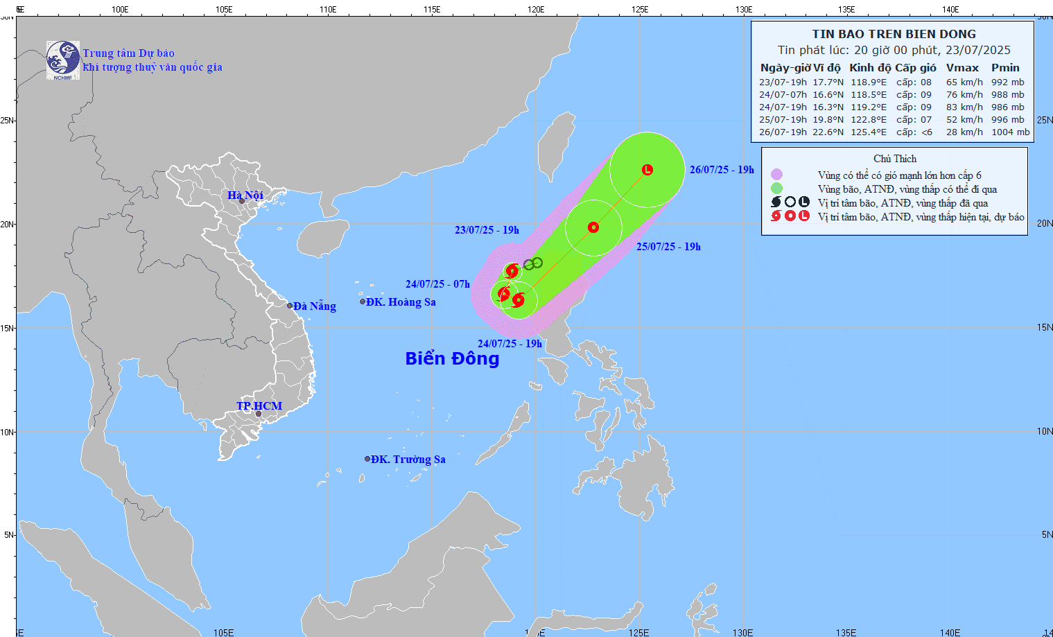
| The tropical depression has strengthened into a storm, becoming storm number 4 in the East Sea. Photo: KTTV |
At 7 p.m., the center of the storm was located at approximately 17.7 degrees North latitude; 118.9 degrees East longitude, in the eastern sea of the North East Sea. The strongest wind near the center of the storm was level 8 (62-74 km/h), gusting to level 10; moving in a West Southwest direction at a speed of approximately 15 km/h.
At 7:00 a.m. on July 24, the center of the storm was located in the eastern sea of the North East Sea. The strongest wind speed was level 10-15, the storm moved in a south-southwest direction at a speed of about 10-15 km/h and was likely to strengthen. The affected area was the eastern sea of the North East Sea. Disaster risk level 3.
At 7:00 p.m. on July 24, the storm was moving south-southeast at a speed of about 5-10 km/h in the eastern sea of the North East Sea. The strongest wind was at level 9, gusting to level 11. The affected area was the eastern sea of the North East Sea. The disaster risk level was level 3.
At 7:00 p.m. on July 25, the storm was moving northeast at a speed of about 20-25 km/h and gradually weakening into a tropical depression. The strongest wind was level 7, gusting to level 9. The affected area was the eastern sea area of the North East Sea. Disaster risk level 3.
At 7:00 p.m. on July 26, the storm was moving northeast at a speed of about 15-20 km/h and weakened into a low pressure area. Wind force below level 6.
Due to the impact of the storm, the eastern sea area of the North East Sea has strong winds of level 6-7, the area near the storm center has strong winds of level 8-9, gusts of level 11, waves 3-5m high, very rough seas.
Ships operating in the above mentioned dangerous areas are likely to be affected by storms, whirlwinds, strong winds and large waves.
Along with that, information from the National Center for Hydro-Meteorological Forecasting, from 7:40 p.m. on July 23 to 12:40 p.m. on July 24, Phu Tho province continued to have rain with accumulated rainfall ranging from 20-40mm, in some places over 90mm. There is a risk of flash floods on small rivers and streams, landslides on steep slopes in the above provinces, especially in the following communes/wards: Muong Hoa; Ban Nguyen, Cu Dong, Da Bac, Dao Xa, Lai Dong, Long Coc, Mai Chau, Mai Ha, Muong Bi, Muong Thang, Ngoc Son, Pa Co, Phung Nguyen, Quyet Thang, Tam Nong, Tan Lac, Tan Son, Thanh Son, Thanh Thuy, Tho Van, Thung Nai, Toan Thang, Tu Vu, Van Son, Vo Mieu, Xuan Dai.
Warning level of natural disaster risk due to flash floods, landslides, land subsidence due to heavy rain or level 1 flow.
Flash floods and landslides can have very negative impacts on the environment, threaten people's lives; cause local traffic congestion, affect the movement of vehicles; destroy civil and economic works, causing damage to production and socio -economic activities.
The hydrometeorological agency recommends that local authorities pay attention to reviewing bottlenecks and vulnerable locations in the area to take preventive and response measures.
From 4:00 p.m. to 7:00 p.m. on July 23, Phu Tho province had moderate and heavy rain such as Trung Hoa 83.6mm, Phu Vinh 54mm,...
Soil moisture models show that some areas in Phu Tho province are nearly saturated (over 85%) or have reached saturation.
According to VNA
Source: https://baoapbac.vn/xa-hoi/202507/ap-thap-nhiet-doi-da-manh-len-thanh-bao-so-4-tren-bien-dong-1047224/


![[Infographic] Vietnam-Senegal traditional friendship](https://vphoto.vietnam.vn/thumb/1200x675/vietnam/resource/IMAGE/2025/7/23/4c96a604979345adb452af1d439d457b)


Comment (0)