
Mr. Vu Anh Tuan, Deputy Head of Weather Forecast Department, National Center for Hydro-Meteorological Forecasting, said that currently (June 9), the low pressure trough with its axis passing through the North East Sea connects with the low pressure area located at 1:00 a.m. this morning at about 16.5-17.5 degrees North latitude, 117.5-118.5 degrees East longitude.
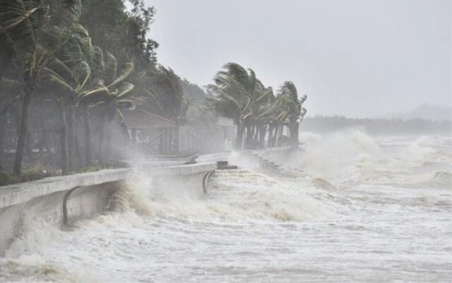
The southern sea area of the North East Sea (including the Hoang Sa archipelago), the central and southern East Sea area (including the Truong Sa archipelago), the sea area from Binh Thuan to Ca Mau, Ca Mau to Kien Giang and the Gulf of Thailand will have showers and thunderstorms. At Huyen Tran station, there were gusts of wind at level 8-9.
A low pressure area is appearing in the East Sea and is likely to strengthen.
Forecast for the day and night of June 9, the southern sea area of the North East Sea (including the Hoang Sa archipelago), the central and southern East Sea area (including the Truong Sa archipelago), the sea area from Binh Dinh to Ca Mau , Ca Mau to Kien Giang and the Gulf of Thailand will have showers and strong thunderstorms. On the night of June 9, in the northern Gulf of Tonkin, there will be scattered showers and thunderstorms. During the storm, there is a possibility of tornadoes, strong gusts of wind level 6-7 and waves over 2.0m high.
In addition, the sea area from Binh Thuan to Ca Mau, the sea area south of the Central East Sea area, the South East Sea area (including the sea area of Truong Sa archipelago) has strong southwest winds of level 5, sometimes level 6, gusting to level 7-8, rough seas. Waves are 1.5 - 3.0m high. All ships operating in the above areas are at risk of being affected by tornadoes, strong gusts of wind and high waves.
Dr. Nguyen Ngoc Huy, an expert on climate change and natural disaster warning, said that early this morning, a low pressure area appeared in the East Sea in the area east of the Hoang Sa archipelago, bordering the central Philippines. There is a high possibility that this low pressure area will develop into a tropical depression and the possibility of developing into a storm cannot be ruled out. It is necessary to closely monitor the developments of this low pressure area.
Experts recommend that fishing boats should not operate in the Hoang Sa and Truong Sa waters in the coming days to reduce the risk of big waves and strong winds.
Source: suckhoedoisong
View original linkSource: https://baotayninh.vn/xuat-hien-vung-ap-thap-o-bien-dong-co-kha-nang-manh-len-thanh-bao-a191136.html


Comment (0)