
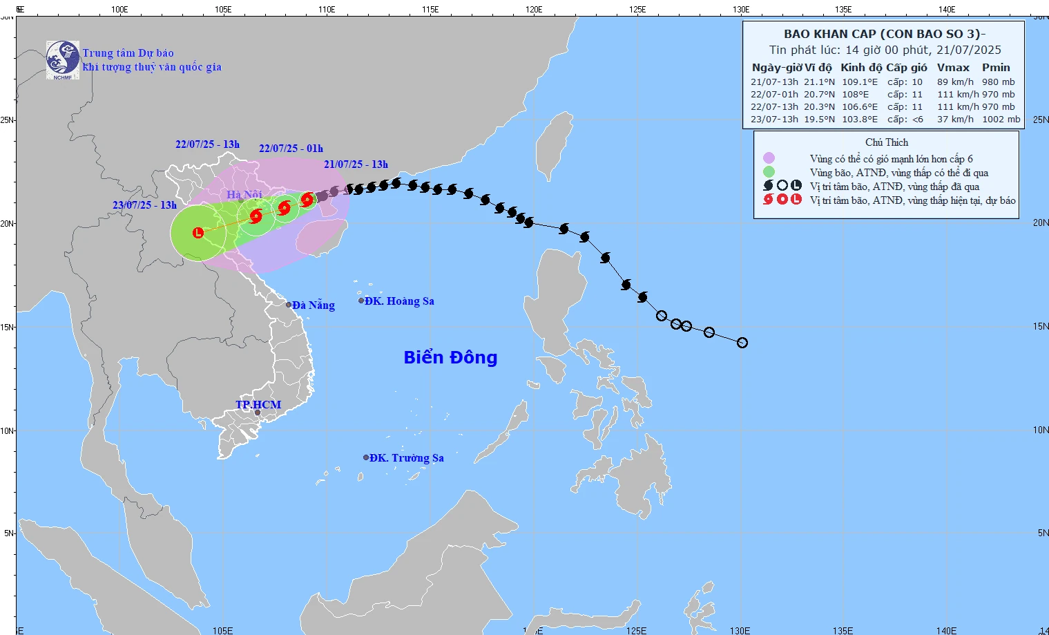
Forecast path of storm No. 3 at 2:00 p.m. on July 21, 2025.
The strongest wind is level 9–10 (75–102 km/h), gusting to level 12. The storm is moving West Southwest at a speed of 10–15 km/h.
By 01:00 on July 22, the storm will move west-southwest at a speed of about 10-15km/h and is likely to strengthen. The center of the storm will then be in the northern part of the Gulf of Tonkin, at about 20.7 degrees north latitude and 108.0 degrees east longitude. The storm intensity will reach level 10-11, gusting to level 14.
The dangerous area at sea at this time is the area north of latitude 18.5 degrees North, from longitude 106.0 to 112.0 degrees East. The affected area includes the northwestern sea area of the North East Sea, the Gulf of Tonkin, and the coastal waters of the provinces from Quang Ninh to Ninh Binh . The level of natural disaster risk is assessed as level 3.
As of 1 p.m. on July 22, the storm continued to move west-southwest at the same speed. The center of the storm is forecast to be located in the sea area from Hai Phong to Thanh Hoa, at about 20.3 degrees North latitude and 106.6 degrees East longitude. The storm intensity remains at level 10-11, gusting to level 14.
The danger zone extends to the west, north of latitude 18.5 degrees north and west of longitude 110.0 degrees east. Affected areas include the Gulf of Tonkin, coastal waters and mainland provinces from Quang Ninh to Nghe An . The disaster risk level remains at level 3.
By 1 p.m. on July 23, the storm is forecast to continue moving west-southwest at a speed of 10-15 km/h and gradually weaken into a low-pressure area. The center of the low-pressure area will be located over the mainland of Upper Laos, at approximately 19.5 degrees North latitude and 103.8 degrees East longitude.
The intensity has now dropped below level 6. The danger zone is the area north of latitude 18.0 degrees North and west of longitude 109.0 degrees East. The affected area continues to include the Gulf of Tonkin, coastal waters and mainland provinces from Quang Ninh to Nghe An. The disaster risk level remains at level 3 due to continued strong winds and heavy rain.
On the sea:
Northwest of the North East Sea: wind level 7-8, gust level 10; waves 3.0-5.0m; rough seas.
Northern Gulf of Tonkin (Bach Long Vi, Co To, Van Don, Cat Hai, Hon Dau): wind level 6–7, increasing to level 8–9, near the storm center level 10–11, gusting to level 14; waves 4.0–6.0m; rough seas.
Southern Gulf of Tonkin (Hon Ngu): wind gradually increases to level 6–7, near the storm center level 8–9, gusting to level 11; waves 2.0–4.0m high; very rough seas.
From the evening and night of July 21: coastal areas from Quang Ninh to Nghe An have strong winds of level 7-9, areas near the storm center have winds of level 10-11, gusting to level 14.
Inland areas such as Hai Phong, Hung Yen, Ninh Binh, Thanh Hoa: wind level 6, gust level 7-8.
Impact: Winds of level 10–11 can cause trees, power poles, roofs to fall, and severe damage.
From July 21–23: Northeast, Northern Delta, Thanh Hoa, Nghe An: 200–350mm, some places over 600mm
Other places in the North and Ha Tinh: 100–200mm, some places over 300mm
Risk: Extremely heavy rain (>150mm/3h)
Flash floods, landslides in mountainous areas, flooding in low-lying and urban areas
Disaster risk level: Level 3: Gulf of Tonkin, coastal waters and mainland from Quang Ninh to Nghe An.
NDS
Source: https://baothanhhoa.vn/thong-tin-moi-nhat-ve-con-bao-so-3--cach-quang-ninh-khoang-120km-255563.htm


![[Photo] National Assembly Chairman Tran Thanh Man visits Vietnamese Heroic Mother Ta Thi Tran](https://vphoto.vietnam.vn/thumb/1200x675/vietnam/resource/IMAGE/2025/7/20/765c0bd057dd44ad83ab89fe0255b783)


Comment (0)