
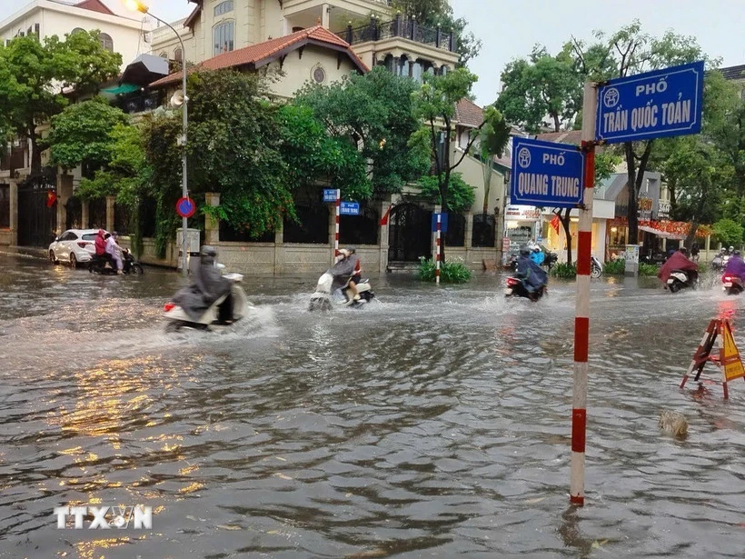
According to the National Center for Hydro-Meteorological Forecasting, on July 13, Hanoi will have the lowest temperature of 25-27 degrees Celsius, the highest temperature of 30-33 degrees Celsius, some places above 33 degrees Celsius. There will be scattered showers and thunderstorms, with intermittent sunshine during the day. During thunderstorms, there is a possibility of tornadoes, lightning and strong gusts of wind.
The lowest temperature in the Northwest is 23-26 degrees Celsius, some places below 23 degrees Celsius, the highest temperature is 30-33 degrees Celsius, some places above 33 degrees Celsius. There are scattered showers and thunderstorms, locally heavy rain (rain is concentrated in the late afternoon and at night). During thunderstorms, there is a possibility of tornadoes, lightning, hail and strong gusts of wind.
In the Northeast region, the lowest temperature is 24-27 degrees Celsius, the highest temperature is 31-34 degrees Celsius. There are scattered showers and thunderstorms in some places, with heavy rain in some places; intermittent sunshine during the day. Light wind. During thunderstorms, there is a possibility of tornadoes, lightning, hail and strong gusts of wind.
From Thanh Hoa to Hue, the lowest temperature is 24-27 degrees Celsius, the highest temperature is 31-34 degrees Celsius. Sunny days, showers and thunderstorms in some places in the late afternoon and night, especially Thanh Hoa - Nghe An with scattered showers and thunderstorms, locally heavy rain. Light wind in the North, southwest wind level 2-3 in the South. During thunderstorms, there is a possibility of tornadoes, lightning and strong gusts of wind.
South Central Coast lowest temperature 25-28 degrees Celsius, highest temperature 32-35 degrees, some places over 35 degrees Celsius. Sunny days, some places hot, late afternoon and night with showers and thunderstorms in some places. Southwest wind level 2-3. During thunderstorms there is a possibility of tornadoes, lightning and strong gusts of wind.
In the Central Highlands, the lowest temperature is 20-23 degrees Celsius, the highest temperature is 27-30 degrees Celsius, some places are over 30 degrees Celsius. There are scattered showers and thunderstorms; in the afternoon and evening, there are scattered showers and thunderstorms, locally heavy rain. Southwest wind level 2-3. During thunderstorms, there is a possibility of tornadoes, lightning and strong gusts of wind.
In the South, the lowest temperature is 24-27 degrees Celsius, the highest temperature is 30-33 degrees Celsius, some places are over 33 degrees Celsius. There are showers and thunderstorms in some places; in the afternoon and evening there are showers and scattered thunderstorms, locally heavy rain in some places. Southwest wind level 2-3. During thunderstorms, there is a possibility of tornadoes, lightning and strong gusts of wind.
Ho Chi Minh City has the lowest temperature of 25-27 degrees Celsius, the highest temperature of 32-34 degrees Celsius. There are showers and thunderstorms in some places; in the afternoon and evening there are showers and scattered thunderstorms, locally heavy rain. Southwest wind level 2-3. During thunderstorms there is a possibility of tornadoes, lightning and strong gusts of wind.
According to the National Center for Hydro-Meteorological Forecasting, last night and early this morning, the Northern region and Thanh Hoa had scattered showers and thunderstorms, with some places experiencing heavy rain. The rainfall from 7:00 p.m. on July 12 to 3:00 a.m. this morning exceeded 50mm in some places, typically: Lac Luong station (Phu Tho) 98.4mm, Yen Thang station (Thanh Hoa) 69.2mm, Lam Thuong station (Lao Cai) 61.4mm, Truong Luong station (Cao Bang) 60.4mm and Ky Lam station (Tuyen Quang) 57.8mm.
It is forecasted that during the day and night of July 13, the Northern region will continue to have scattered showers and thunderstorms, locally heavy rain with common rainfall from 10-30mm, some places over 50mm.
This afternoon and evening, the area from Thanh Hoa to Nghe An, the Central Highlands and the South will also have scattered showers and thunderstorms, locally heavy rain, rainfall ranging from 10-30mm, some places may have over 60mm. During thunderstorms, there is a possibility of tornadoes, lightning, hail and strong gusts of wind.
Localized heavy rains may cause flash floods on small rivers and streams, landslides on steep slopes and flooding in low-lying areas. Warning level of natural disaster risk due to tornadoes, lightning and hail is at level 1.
Currently, in the Gulf of Tonkin and the southern sea area of the central East Sea, there are showers and thunderstorms.
It is forecasted that during the day and night of July 13, the Gulf of Tonkin, the central and southern East Sea (including the Truong Sa archipelago), the sea area from Binh Thuan to Ca Mau, from Ca Mau to Kien Giang and the Gulf of Thailand will continue to have scattered showers and thunderstorms. During thunderstorms, there is a possibility of tornadoes, strong gusts of wind and waves over 2m high. All vessels operating in the above sea areas are at high risk of being affected by tornadoes and strong gusts of wind.
Source: VNA
Source: https://baophutho.vn/thoi-tiet-ngay-13-7-mua-dong-dien-rong-bien-dong-canh-bao-thien-tai-cap-1-236050.htm


Comment (0)