
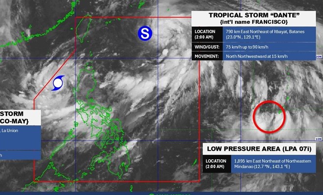
Location of storm No. 4 in the East Sea (Comay), storm Francisco and low pressure near the Philippines at 2:00 a.m. on July 24. Photo: PAGASA
The latest storm news from the Philippine Atmospheric, Geophysical and Astronomical Services Administration (PAGASA) said that at 4:00 a.m. on July 24, the center of storm Emong (international name Comay - or storm number 4 in the East Sea) was at about 16.7 degrees north latitude; 118.3 degrees east longitude, in the eastern sea of the North East Sea, about 245km west of Bacnotan (La Union, Philippines).
Storm intensity level 8-9 (62-88 km/h), gust level 11. Storm moves in South Southeast direction, speed about 15 km/h.
Strong wind radius up to 220km from the center of the storm.
Storm No. 4 causes rough seas, waves in La Union and Ilocos Sur can be up to 14m high.
Storm No. 4 may make landfall in Ilocos from the evening of July 24 to the early morning of July 25. After that, the storm's eye may continue to enter the Luzon Strait, moving near the Babuyan Islands.
Meanwhile, according to the storm forecast of the Vietnam National Center for Hydro-Meteorological Forecasting, as of 4:00 p.m. on July 24, the center of storm No. 4 was at 16.3 degrees north latitude; 119.3 degrees east longitude; in the eastern sea of the North East Sea. Intensity level 9-10, gust level 12. The storm is moving in the East Southeast direction, 10-15 km/h. Areas affected by level 3 natural disaster risk: Eastern sea area of the North East Sea.
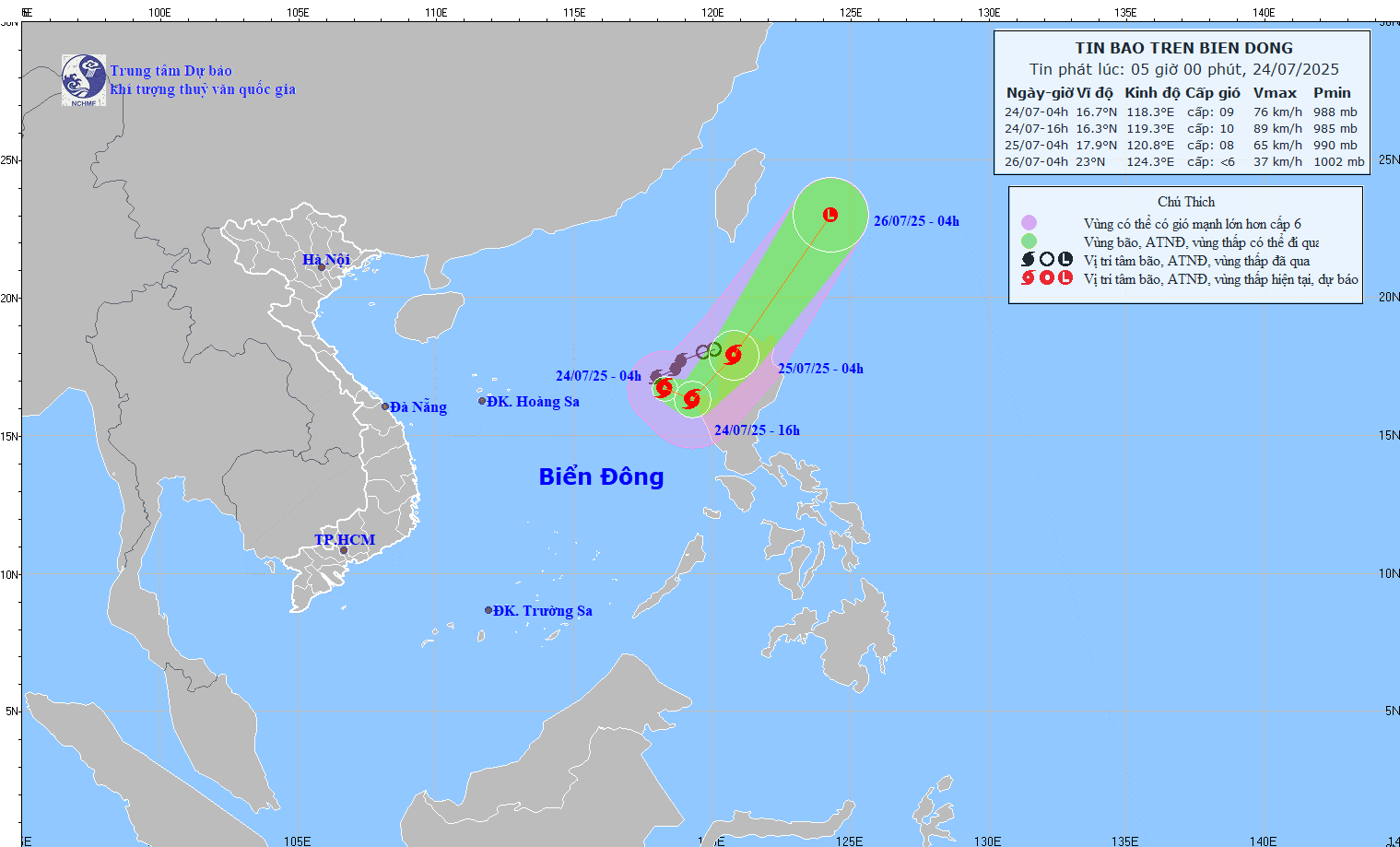
Forecast of the path of storm No. 4. Photo: Vietnam National Center for Hydro-Meteorological Forecasting
At 4:00 a.m. on July 25, the center of the storm was at 17.9 degrees north latitude; 120.8 degrees east longitude; on the northern mainland of the Luzon Peninsula, Philippines. The storm intensity was level 8, gusting to level 10. The storm moved northeast at 20-25 km/h. The eastern sea area of the North East Sea was at risk of level 3 natural disasters.
It is forecasted that by 4:00 a.m. on July 26, storm No. 4 will gradually weaken into a low pressure area.
On July 24, the eastern sea of the North East Sea has strong winds of level 7-8, near the storm center, strong winds of level 9-10, gusting to level 12. Waves are 4.0-6.0m high, very rough seas.
At the same time, typhoon Dante, international name Francisco, is moving rapidly northwest towards the Ryukyu Islands (Japan) and the East China Sea.
According to PAGASA, the center of storm Francisco at 4:00 a.m. on July 24 was about 790km northeast of Itbayat (Batanes).
Current winds: 75 km/h, gusts to 90 km/h, central pressure 994 hPa.
Travel speed: 15 km/h.
Radius of influence: Strong winds spread up to 550 km.
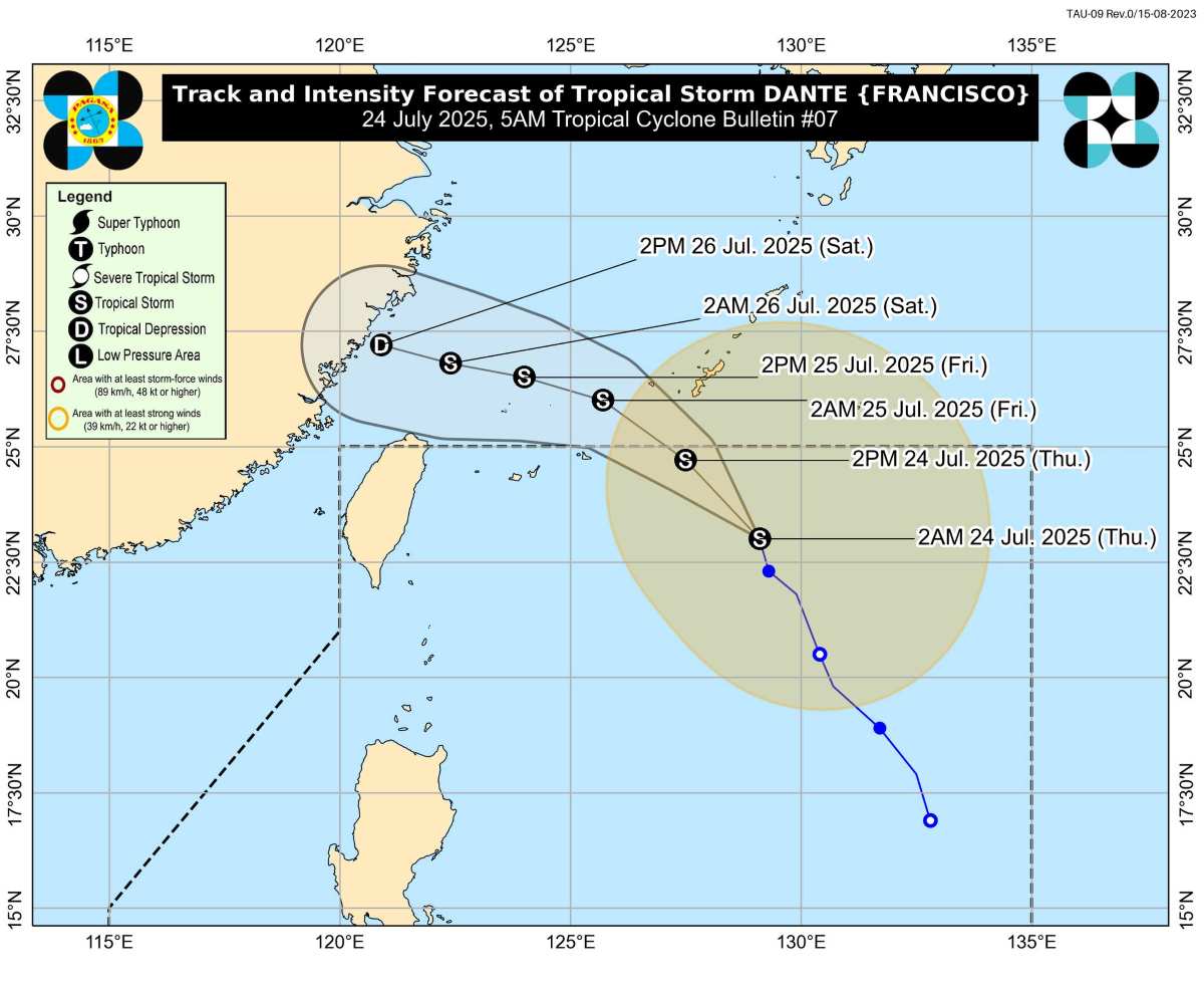
Forecasted path of Typhoon Dante (Francisco). Photo: PAGASA
Typhoon Dante is expected to leave the Philippine Forecast Area (PAR) this afternoon or evening (July 24). Although it has not strengthened much, the storm continues to cause rough seas in many coastal areas of the northern and central Philippines.
PAGASA warned all types of vessels, especially small fishing boats, to avoid going out to sea, or seek immediate shelter due to very rough seas in many areas.
Waves 14m high: Ilocos Sur and La Union coasts. Waves 11m high: Pangasinan coast. Waves 8m high: Zambales. Waves 6m high: Bataan. Waves 4.5m high and above: Batangas, Lubang Island, Occidental Mindoro.
In addition, the sea areas of Palawan, Calamian, Batanes, Cagayan, Catanduanes, Romblon, Davao... are all affected by waves of 2-4m, posing a high risk to small boats.
Given the complex developments of the two storms, residents in the area are advised to evacuate when ordered, stay away from the coast, low-lying areas or areas at risk of landslides. Closely monitor weather forecasts from PAGASA, do not share fake news.
Laodong.vn
Source: https://laodong.vn/the-gioi/du-bao-thoi-diem-bao-so-4-tren-bien-dong-va-bao-francisco-do-bo-1545731.ldo


![[Photo] Signing of cooperation between ministries, branches and localities of Vietnam and Senegal](https://vphoto.vietnam.vn/thumb/1200x675/vietnam/resource/IMAGE/2025/7/24/6147c654b0ae4f2793188e982e272651)


Comment (0)