
 |
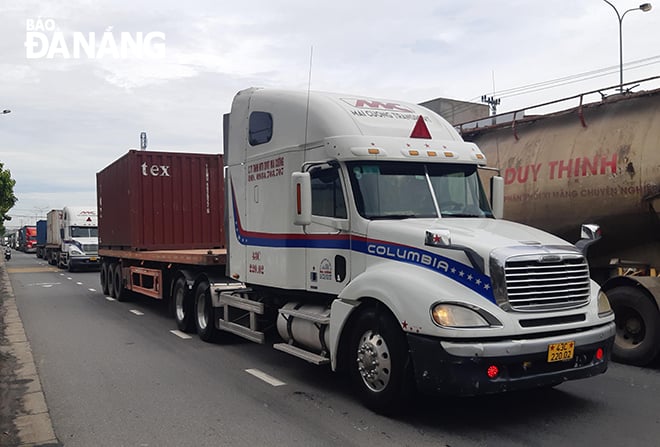
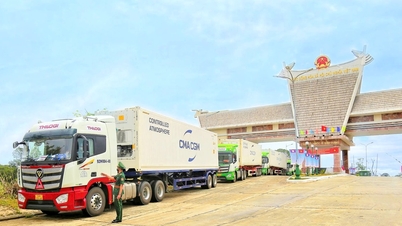
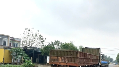
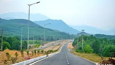
| Vehicles traveling on National Highway 14B, through the city. Photo: THANH LAN |
According to Mr. Tran Van Tuyen, who lives on Cach Mang Thang Tam Street, this is a route that passes through many densely populated residential areas such as Khue Trung, Hoa Cuong, Hoa Tho, etc. with the city center. At the same time, this route concentrates a large number of trucks and containers from Tien Sa port to Hoa Cam industrial park, National Highway 1A and the Central Highlands provinces, leading to great pressure during rush hours.
Sharing the same opinion, Mr. Ho Tan Trong, a container truck driver who regularly transports goods to Tien Sa port, said that at some intersections on the route, as well as nearby intersections such as: Cach Mang Thang Tam - Nguyen Huu Tho intersection, Xuan Thuy - Cach Mang Thang Tam intersection, Le Thanh Nghi - Cach Mang Thang Tam intersection, or the section near Hoa Cuong wholesale market, Thang Long intersection - Hoa Xuan bridgehead, conflicts often occur between vehicles turning left, going straight, and making U-turns.
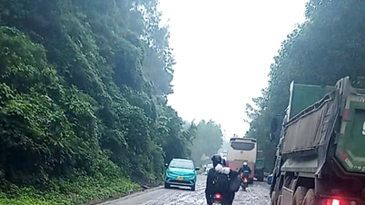
In particular, motorbikes, trucks, and cars traveling in the same lane cause dangerous conflicts. Meanwhile, many intersections have unreasonable traffic lights or do not have effective speed-reducing roundabouts, causing unstable traffic conditions...
In addition, near markets, residential areas or along cross-sections, maintenance, repair or construction of infrastructure works such as drainage systems, electrical pipes, etc. often narrow the road surface, causing unsafety and increasing the risk of traffic jams.
The road surface in some sections has deteriorated, creating potholes, causing danger when vehicles avoid each other or move quickly, motorbikes stopping and parking arbitrarily, people crossing the road in the wrong place creating more risks of collisions and accidents... According to statistics, every day, thousands of container trucks and heavy trucks enter and exit the port, moving along the Ngo Quyen - Ngu Hanh Son - Tien Son bridge - Cach Mang Thang Tam - National Highway 1A axis. Along with that, a large part of the traffic is concentrated on National Highway 14B or the Hai Van South bypass, causing pressure at the intersections of Tien Son, Nguyen Huu Tho, and Cach Mang Thang Tam bridges, especially during rush hour.
Faced with this situation, many drivers believe that it is necessary to re-divided traffic by the hour for heavy trucks, and ban them from entering during rush hours. Experiment with a model of lane division like the Ho Xuan Huong - Tien Sa route. At the same time, widen the road surface, add separate lanes for motorbikes as well as improve intersections, install traffic lights, small roundabouts, and clear lane lines... Regarding the solution to apply the model of the Ho Xuan Huong - Tien Sa route, currently, when there is very effective lane division for container trucks, the west side of Tien Son - Hoa Cam bridge still does not have corresponding measures, making this section a "bottleneck".
The city's functional departments said that both routes are on National Highway 14B, with a very high density of container trucks and heavy trucks; they are routes connecting the port, industrial park and the city center. These routes are under great pressure during rush hour and have accidents due to traffic conflicts, so they can be applied, but need to be adjusted flexibly due to the characteristics of this route, which has many residential roads and markets.
According to the representative of the Da Nang Road Freight Transport Association, the section west of Tien Son Bridge to Tuy Loan intersection is under great pressure from inter-regional traffic, especially freight transport. Without drastic and synchronous solutions from infrastructure, traffic organization to legal corridors and public awareness, this area will continue to be a hot spot for traffic congestion and accidents in the coming time. Therefore, applying and adjusting the traffic flow model from Ho Xuan Huong - Tien Sa port route is a feasible direction that needs to be piloted in the coming time.
In addition, the route plays an important role in Da Nang's urban traffic. The frequent occurrence of traffic jams and accidents is a warning about the pressure on infrastructure and urban management. The city needs to have synchronous, long-term and flexible solutions, combining planning, infrastructure upgrades and awareness of traffic participants, to ensure safety and smoothness for the entire route.
| The Ministry of Construction and the City People's Committee are implementing a project to upgrade and renovate National Highway 14B (from Tuy Loan intersection to the border with Quang Nam province) from 2 lanes to 4 lanes. Therefore, to synchronize traffic on National Highway 14B, the section passing through the city, the redevelopment of the lane division from the western section of Tien Son bridge to Tuy Loan intersection needs to be calculated soon. |
THANH LAN
Source: https://baodanang.vn/xa-hoi/202506/can-ap-dung-phan-lan-doan-tuyen-tu-cau-tien-son-den-nut-giao-tuy-loan-4010643/
![[Photo] General Secretary To Lam works with the Standing Committee of Quang Binh and Quang Tri Provincial Party Committees](https://vphoto.vietnam.vn/thumb/1200x675/vietnam/resource/IMAGE/2025/6/25/6acdc70e139d44beaef4133fefbe2c7f)


![[Infographic] Circular regulating the decentralization and division of authority of local authorities at two levels in the field of culture, sports and tourism](https://vphoto.vietnam.vn/thumb/402x226/vietnam/resource/IMAGE/2025/6/25/b35f975208474e129486cdc9841c240c)
![[Infographic] Demarcation of authority of two-level local government in the fields of culture, sports and tourism](https://vphoto.vietnam.vn/thumb/402x226/vietnam/resource/IMAGE/2025/6/25/594a47cf796643efbd52c77da8b6fee6)


Comment (0)