

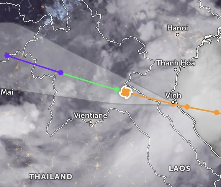
Updated at 5:00 a.m. today, August 26, storm No. 5 (Kajiki) after making landfall in the North Central region of Vietnam (from about 5:00 p.m. on August 25) and moving deep into the mainland of Vietnam and Laos, but is still identified as a tropical storm according to international monitoring data.
At 4:50 a.m. today, satellite images from Zoom Earth showed the storm center in Xiangkhouang province (Laos), near Phonsavan town, about 220km northeast of the capital Vientiane, with sustained tropical storm-force winds and dense convective clouds covering the entire area.

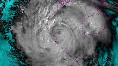
According to the Japan Meteorological Agency (JMA), at 9:00 p.m. UTC on August 25 (4:00 a.m. on August 26, Vietnam time), Kajiki remained at tropical storm level (TS), with a central pressure of 996hPa, maximum winds equivalent to 74km/h, and gusts of 60 about 111km/h.

The Joint Typhoon Warning Center (JTWC, USA) at the same time also recorded that Kajiki was still a tropical storm (not yet weakened into a tropical depression).
Meteorological experts analyzed that the fact that Kajiki remained a storm even after moving deep into Laos shows that the vortex structure of this system is still relatively tight, and that areas of rain and strong winds are still widespread, especially in the North Central region, Laos and Thailand.
Currently, international meteorological stations believe that this cyclone is likely to continue moving deep into the West Northwest, reaching the Laos - Thailand border area, and even the Thailand - Myanmar border before dissipating.
Meanwhile, Vietnam's National Center for Hydro-Meteorological Forecasting said that early on August 26, storm No. 5 weakened into a tropical depression in Central Laos.

At 4:00 a.m. on August 26, the center of the tropical depression was at about 18.9 degrees North latitude and 104.5 degrees East longitude, with the strongest wind at level 7 (50-61 km/h), gusting to level 9, moving in the West Northwest direction at a speed of 15-20 km/h.
It is forecasted that by 4:00 p.m. on August 26, the tropical depression will be located at about 19.3 degrees North latitude and 102.1 degrees East longitude (Central Laos), weakening into a low pressure area with winds below level 6.
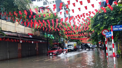
The National Center for Hydro-Meteorological Forecasting predicts that heavy rain will continue to occur on August 26 in the midlands and deltas of the North, Lao Cai, Son La, Thanh Hoa - Ha Tinh provinces with common rainfall of 50-100mm, some places over 200mm, with a risk of heavy rain with an intensity of over 100mm in 3 hours.

 was deeply flooded in the early morning of August 26.")
Hanoi continues to have heavy rain with thunderstorms, while Da Nang has no rain and Ho Chi Minh City has showers and thunderstorms in the evening. On August 26 and 27, the Upper Laos and Central Laos regions will have widespread rain of 100-250mm, locally over 500mm.


Meteorological agencies warn that the storm's circulation will continue to cause heavy rain, some very heavy rain, in the North Central region and the northern mountainous region today, with a high risk of flash floods and landslides in the central and northwestern provinces.
Source: https://www.sggp.org.vn/bao-so-5-di-sau-vao-dat-lien-viet-nam-lao-gay-mua-to-gio-manh-dien-rong-post810149.html


![[Photo] Multi-colored cultural space at the Exhibition "80 years of the journey of Independence - Freedom - Happiness"](https://vphoto.vietnam.vn/thumb/1200x675/vietnam/resource/IMAGE/2025/8/26/fe69de34803e4ac1bf88ce49813d95d8)
![[Photo] Hanoi: Authorities work hard to overcome the effects of heavy rain](https://vphoto.vietnam.vn/thumb/1200x675/vietnam/resource/IMAGE/2025/8/26/380f98ee36a34e62a9b7894b020112a8)


Comment (0)