
In the past 12 hours, storm number 3 Wipha has decreased by 3 levels, from level 12, gusting to level 15, to level 9, gusting to level 12, as it moves over mainland China. However, when entering the Gulf of Tonkin, the storm is likely to strengthen again.
Early morning of July 21, the center of storm No. 3 was on the Leizhou peninsula (China). At 6am, the storm was about 233km east of Quang Ninh - Hai Phong . The strongest wind near the storm center was level 9 (75-88 km/h), gusting to level 11. It is forecasted that in the next 3 hours, the storm will move in a West-Southwest direction, at a speed of about 15-20km/h.
At around 4am on July 22, storm number 3 Wipha in the northern Gulf of Tonkin moved west-southwest at about 15km per hour and was likely to strengthen. The strongest wind near the storm's center was at level 10-11, gusting to level 14.
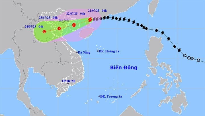
At 4:00 a.m. on July 23, storm No. 3 Wipha on the mainland of Hung Yen - Thanh Hoa provinces continued to move in the West Southwest direction, at a speed of 10-15 km/h and gradually weakened into a tropical depression with the strongest wind at level 6-7, gusting to level 9.
Forecast at 4:00 a.m. on July 24, the tropical depression on land in the Upper Laos region will move in the West Southwest direction at a speed of 10-15 km/h and gradually weaken into a low pressure area.
Storm No. 3 Wipha will cause very bad weather at sea, with waves 6m high in some places, and very heavy rain in the Northern and North Central regions of our country.
Forecast: Northwestern sea area of North East Sea area has strong wind level 7-8, near the storm center level 9, gust level 11, waves 4-6m high, very rough sea. North sea area of Bac Bo Gulf (including Bach Long Vi, Co To, Cat Hai, Hon Dau island) has strong wind level 6-7, then increasing to level 8-9, near the storm center level 10-11, gust level 14, waves 2-4m high, near the storm center 3-5mm, rough sea. South sea area of Bac Bo Gulf (including Hon Ngu island) has strong wind level 6-7, near the storm center level 8-9, gust level 11, waves 2-4m high, very rough sea.
The coastal areas of Hai Phong - Quang Ninh have storm surges of 0.5-1m. The water level at Hon Dau (Hai Phong) is 3.7-4.1m, Cua Ong ( Quang Ninh ) is 4.4-4.8m and Tra Co ( Quang Ninh ) is 3.6-4m. There is a high risk of flooding in coastal areas and river mouths on the afternoon of July 22.
"The weather at sea and in coastal areas during storms is extremely dangerous and unsafe for any means or structures operating in dangerous areas such as cruise ships, passenger ships, transport ships, cages, rafts, aquaculture areas, dykes, embankments, and coastal routes.
Vehicles are at high risk of capsizing, destruction, and flooding due to strong winds, storms, tornadoes, large waves, and rising sea levels," Meteorological agency warning.
On land, from the evening and night of July 21, coastal areas from Quang Ninh to Nghe An will see winds gradually increase to level 7-9, near the storm center, level 10-11, gusting to level 14, deep inland, strong winds of level 6, gusting to level 7-8. Winds of level 10-11 can knock down trees, electric poles, and rip off roofs, causing very heavy damage.
On July 21-23, the Northeast region, the Northern Delta, Thanh Hoa and Nghe An will have heavy to very heavy rain and thunderstorms with common rainfall of 200-350mm, in some places over 600mm.
Other places in the North and Ha Tinh have moderate rain, heavy rain, locally very heavy rain and thunderstorms with rainfall ranging from 100-200mm, in some places over 300mm.
Risk of heavy rain, over 150mm in just 3 hours. Heavy rainfall in a short period of time can cause flash floods, landslides in mountainous areas, flooding in low-lying areas. During thunderstorms, beware of extreme weather phenomena such as tornadoes, lightning, hail and strong gusts of wind.
Source: https://baolangson.vn/bao-so-3-wipha-cach-hai-phong-quang-ninh-233km-bac-bo-va-bac-trung-bo-mua-lon-5053724.html


![[Photo] National Assembly Chairman Tran Thanh Man visits Vietnamese Heroic Mother Ta Thi Tran](https://vphoto.vietnam.vn/thumb/1200x675/vietnam/resource/IMAGE/2025/7/20/765c0bd057dd44ad83ab89fe0255b783)


Comment (0)