
Storm status information
Due to the influence of storm number 3, many coastal and inland areas have had strong winds:
White Dragon Tail level 10, jerk level 12
Co To level 8, jerk level 11
Cat Ba (Cat Hai special zone) level 6, jerk level 8
Level 9 Ong Gate, Level 12
Bai Chay level 8, jerk level 9
Quang Ha level 8
Tien Yen level 7, jerk level 9
Thai Binh level 7, shock level 8
Mong Cai level 6, jerk level 9
Level 6 Lien Palace, Level 8 Shock

The Northern Delta and coastal areas, Thanh Hoa, Nghe An have moderate rain, heavy rain, and some places have very heavy rain, with common rainfall of 50-100mm, and some places >130mm.
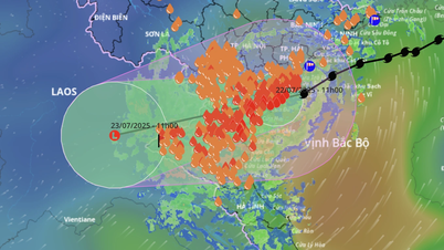
At 4:00 a.m. on July 22, the storm center was at about 20.5°N; 107.2°E, about 140km from Quang Ninh, 70km from Hai Phong , 80km from Hung Yen, and 100km from Ninh Binh. The strongest wind near the storm center was level 9-10 (75–102km/h), gusting to level 13. The storm moved in a West-Southwest direction at a speed of 15km/h.
Storm forecast number 3
4:00 p.m. July 22: On land Hai Phong - Thanh Hoa level 8, gust level 10.
04:00 on July 23: Over the Vietnam - Laos border area, weakened into a low pressure area.
At sea : Northern Gulf of Tonkin: wind level 7–8, near the storm center level 9–10, gusts level 13; waves 2–4m high, near the storm center 3-5m; very rough seas. Southern Gulf of Tonkin: wind level 6–7, near the storm center level 8, gusts level 11; waves 2–4m high; rough seas.
On land: Quang Ninh to Nghe An: wind level 7-8, near the storm center level 9-10, gust level 13. Deep inland: Hai Phong, Hung Yen, Bac Ninh, Hanoi, Ninh Binh, Thanh Hoa wind level 6, gust level 7-8. Wind level 9-10 can cause trees, electric poles, roofs to fall, causing very heavy damage.
From early morning of July 22 to July 23, in the Northern Delta region, Thanh Hoa and Nghe An, there will be heavy to very heavy rain and thunderstorms with common rainfall of 200-300mm, locally over 500mm.
Other places in the Northern region and Ha Tinh have moderate rain, heavy rain, locally very heavy rain and thunderstorms with common rainfall of 70-150mm, locally over 250mm.
Storm No. 3 Advisory
High danger at sea: Tourist boats, fish rafts, aquaculture areas... absolutely no operation
Coastal areas from Quang Ninh to Nghe An need to complete bracing houses and evacuate people before July 22.
Warning of heavy rain causing flooding, collapse, flash floods, landslides in mountainous and midland areas. Be careful with extremely heavy rain >150mm/3h causing deep flooding, dangerous to people and property.
Source: https://baolaocai.vn/bao-so-3-giat-cap-13-cach-hai-phong-70km-post649398.html


Comment (0)