

This morning, August 27, the low pressure area in the eastern sea of the North East Sea strengthened into a typhoon. tropical depression
At 10:00 a.m., the center of the tropical depression was at about 17.7 degrees North latitude; 119.0 degrees East longitude, the strongest wind near the center of the tropical depression was level 6 (39 - 49 km/h), gusting to level 8, moving in the West Southwest direction at a speed of 10 - 15 km/h.
It is forecasted that by 10:00 a.m. on August 28, the tropical depression will be about 410 km east of Hoang Sa special zone, with the strongest wind near the center of the tropical depression at level 6-7, gusting to level 9, moving in the West Southwest direction, traveling 15-20 km per hour, with the possibility of further strengthening.
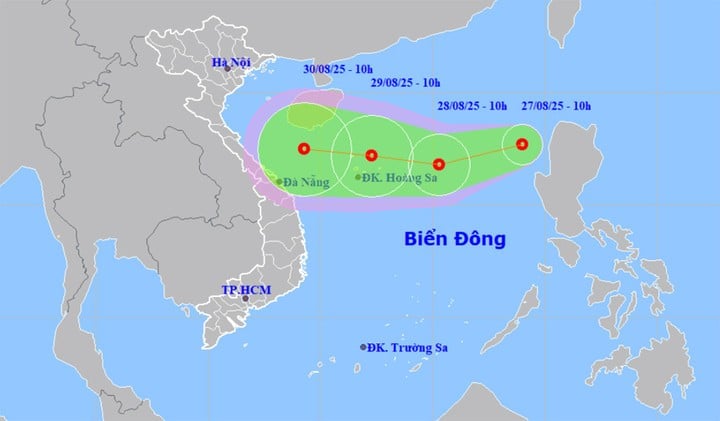
At around 10am on August 29, a tropical depression in the Hoang Sa special zone moved west at a speed of about 15km/h. The strongest wind near the center of the depression was at level 7, gusting to level 9.
From the next 48 to 72 hours, the tropical depression will continue to move mainly in the West direction, traveling 10 - 15km per hour.
Impact of tropical depression, the eastern sea area of the North East Sea has strong winds of level 6-7, gusts of level 9, waves 2-4m high, rough seas.
In addition, the meteorological agency also issued emergency flood news on Thao River, Ma River, flood warning on Luc Nam River, Thuong River and Cau River.
Floods on Thao River (Lao Cai) at Yen Bai station peaked at 32.32m at 1am on August 27, 0.32m above alert level 3 and are receding; floods on Luc Nam River (Bac Ninh), Hoang Long River (Ninh Binh) are receding, downstream Ca River (Nghe An) is rising slowly, downstream Ma River (Thanh Hoa) is at its peak; floods on Thuong River, Cau River (Bac Ninh) are rising.
Water level at 7:00 a.m. on August 27 on Thao River at Yen Bai station was 32.13m, 0.13m above BĐ3 (Dong Sung hydropower plant discharged 737 m3/s); Luc Nam River ( Bac Ninh ) at Luc Nam station was 5.04m, 0.26m below BĐ2; Thuong River (Bac Ninh) at Phu Lang Thuong station was 4.44m, 0.14m above BĐ1; Cau River (Bac Ninh) at Dap Cau station was 3.71m, 0.59m below BĐ1; Hoang Long River at Ben De station was 4.10m, 0.10m above BĐ3; Buoi River at Kim Tan station was 12.76m, 0.76m above BĐ3; Chu River at Xuan Khanh station was 9.65m, 0.65m above BĐ1; Ma River at Ly Nhan station 11.87m, below BĐ3 0.13m; Giang station 6.62m, above BĐ3 0.12m; Ca River at Nam Dan station 5.51m, above BĐ1 0.11m.
It is forecasted that in the next 6-12 hours, the flood in the downstream of Ma River will fall below level 3, and Thao River will continue to fall at level 2-3. In the next 12-24 hours, the flood on Thao River will continue to fall at level 1-2, and the downstream of Ma River will continue to fall and stay above level 2.
On August 27, floods on Thuong River and Cau River continued to rise at level 1 and above, floods on Hoang Long River continued to fall at level 2-3, floods on Luc Nam River continued to fall at level 1. Floods downstream of Ca River fluctuated at level 1.
There is a high risk of flooding in low-lying areas along rivers, flash floods on small rivers and streams, and landslides on steep slopes in the provinces of Lao Cai , Phu Tho, Bac Ninh, Ninh Binh, Thanh Hoa, and Nghe An.
Source: https://baolangson.vn/24-gio-sau-khi-bao-so-5-kajiki-tan-bien-dong-don-ap-thap-nhiet-doi-moi-5057243.html

![[Photo] Parade blocks pass through Hang Khay-Trang Tien during the preliminary rehearsal](https://vphoto.vietnam.vn/thumb/1200x675/vietnam/resource/IMAGE/2025/8/27/456962fff72d40269327ac1d01426969)
![[Photo] Images of the State-level preliminary rehearsal of the military parade at Ba Dinh Square](https://vphoto.vietnam.vn/thumb/1200x675/vietnam/resource/IMAGE/2025/8/27/807e4479c81f408ca16b916ba381b667)


Comment (0)